
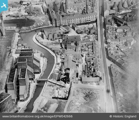
EPW042666 ENGLAND (1933). The Westwood and New Mills (Flint and Stone), Hanley, 1933
© Copyright OpenStreetMap contributors and licensed by the OpenStreetMap Foundation. 2026. Cartography is licensed as CC BY-SA.
Nearby Images (8)
EPW042666
, Hanley, 1933")
EPW042665
, Hanley, 1933")
EPW042669

EPW042670

EPW042668
, Hanley, 1933")
EPW042667
, Hanley, 1933")
EAW036101
 and environs, Hanley, 1951. This image has been produced from a print marked by Aerofilms Ltd for photo editing.")
EAW036102
 and environs, Hanley, 1951. This image has been produced from a print marked by Aerofilms Ltd for photo editing.")
Details
| Title | [EPW042666] The Westwood and New Mills (Flint and Stone), Hanley, 1933 |
| Reference | EPW042666 |
| Date | August-1933 |
| Link | |
| Place name | HANLEY |
| Parish | |
| District | |
| Country | ENGLAND |
| Easting / Northing | 388644, 346658 |
| Longitude / Latitude | -2.1692958555289, 53.016796024067 |
| National Grid Reference | SJ886467 |
Pins

J8mper |
Wednesday 30th of January 2019 08:33:41 AM | |
|
J8mper |
Wednesday 30th of January 2019 08:32:13 AM | |
|
J8mper |
Wednesday 30th of January 2019 08:30:27 AM | |

cidge |
Tuesday 9th of February 2016 11:51:54 PM | |
|
gbaddley |
Thursday 7th of November 2013 08:36:31 PM | |
|
gbaddley |
Thursday 7th of November 2013 08:35:56 PM |