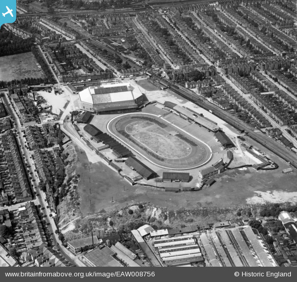
eaw008756 ENGLAND (1947). The Harringay Arena and Stadium, Harringay, 1947
© Copyright OpenStreetMap contributors and licensed by the OpenStreetMap Foundation. 2024. Cartography is licensed as CC BY-SA.
Nearby Images (9)
Details
| Title | [EAW008756] The Harringay Arena and Stadium, Harringay, 1947 |
| Reference | EAW008756 |
| Date | 8-August-1947 |
| Link | |
| Place name | HARRINGAY |
| Parish | |
| District | |
| Country | ENGLAND |
| Easting / Northing | 532063, 188141 |
| Longitude / Latitude | -0.093983072051662, 51.576168686731 |
| National Grid Reference | TQ321881 |
Pins
 John Wass |
Friday 25th of July 2014 09:05:14 PM | |
 cptpies |
Wednesday 18th of December 2013 11:02:24 AM | |
They look like the timber supports for the platform to me. |
 John Wass |
Friday 25th of July 2014 09:02:28 PM |
 cptpies |
Wednesday 18th of December 2013 11:01:31 AM | |
Now these look like "Dragon's Teeth"! |
 John Wass |
Friday 25th of July 2014 09:04:19 PM |


![[EAW008756] The Harringay Arena and Stadium, Harringay, 1947](http://britainfromabove.org.uk/sites/all/libraries/aerofilms-images/public/100x100/EAW/008/EAW008756.jpg)
![[EAW008755] The Harringay Arena and Stadium, Harringay, 1947. This image has been produced from a damaged negative.](http://britainfromabove.org.uk/sites/all/libraries/aerofilms-images/public/100x100/EAW/008/EAW008755.jpg)
![[EPW056659] Harringay Greyhound and Motor Cycle Stadium, Harringay, 1938](http://britainfromabove.org.uk/sites/all/libraries/aerofilms-images/public/100x100/EPW/056/EPW056659.jpg)
![[EPW056660] Harringay Greyhound and Motor Cycle Stadium, Harringay, 1938](http://britainfromabove.org.uk/sites/all/libraries/aerofilms-images/public/100x100/EPW/056/EPW056660.jpg)
![[EPW044028] The British Woodcraft Ltd Piano and Joinery Works alongside Hermitage Road, Harringay, 1934](http://britainfromabove.org.uk/sites/all/libraries/aerofilms-images/public/100x100/EPW/044/EPW044028.jpg)
![[EPW044029] The British Woodcraft Ltd Piano and Joinery Works alongside Hermitage Road, Harringay, 1934](http://britainfromabove.org.uk/sites/all/libraries/aerofilms-images/public/100x100/EPW/044/EPW044029.jpg)
![[EPW044095] The British Woodcraft Ltd Piano and Joinery Works and Harringay Stadium, Harringay, 1934](http://britainfromabove.org.uk/sites/all/libraries/aerofilms-images/public/100x100/EPW/044/EPW044095.jpg)
![[EPW044096] The British Woodcraft Ltd Piano and Joinery Works and Harringay Stadium, Harringay, 1934](http://britainfromabove.org.uk/sites/all/libraries/aerofilms-images/public/100x100/EPW/044/EPW044096.jpg)
![[EPW031662] Harringay Stadium and Green Lanes, Harringay, from the north-west, 1930](http://britainfromabove.org.uk/sites/all/libraries/aerofilms-images/public/100x100/EPW/031/EPW031662.jpg)