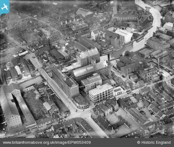
EPW053409 ENGLAND (1937). Swan Flour Mills, Sculcoates Bridge and environs, Kingston upon Hull, 1937
© Copyright OpenStreetMap contributors and licensed by the OpenStreetMap Foundation. 2024. Cartography is licensed as CC BY-SA.
Nearby Images (22)
Details
| Title | [EPW053409] Swan Flour Mills, Sculcoates Bridge and environs, Kingston upon Hull, 1937 |
| Reference | EPW053409 |
| Date | 31-May-1937 |
| Link | |
| Place name | KINGSTON UPON HULL |
| Parish | |
| District | |
| Country | ENGLAND |
| Easting / Northing | 510326, 429999 |
| Longitude / Latitude | -0.32650585789999, 53.754438931583 |
| National Grid Reference | TA103300 |
Pins
 ladyceecee |
Sunday 27th of January 2019 04:53:07 PM | |
 John Wass |
Tuesday 23rd of September 2014 04:35:58 PM | |
 John Wass |
Tuesday 19th of August 2014 04:50:52 PM | |
 John Wass |
Tuesday 19th of August 2014 04:49:56 PM |


![[EPW053409] Swan Flour Mills, Sculcoates Bridge and environs, Kingston upon Hull, 1937](http://britainfromabove.org.uk/sites/all/libraries/aerofilms-images/public/100x100/EPW/053/EPW053409.jpg)
![[EPW053410] Swan Flour Mills and environs, Kingston upon Hull, 1937](http://britainfromabove.org.uk/sites/all/libraries/aerofilms-images/public/100x100/EPW/053/EPW053410.jpg)
![[EPW053412] Swan Flour Mills, Sculcoates Bridge and environs, Kingston upon Hull, 1937](http://britainfromabove.org.uk/sites/all/libraries/aerofilms-images/public/100x100/EPW/053/EPW053412.jpg)
![[EPW053413] Swan Flour Mills, Sculcoates Bridge and environs, Kingston upon Hull, 1937](http://britainfromabove.org.uk/sites/all/libraries/aerofilms-images/public/100x100/EPW/053/EPW053413.jpg)
![[EPW053407] Swan Flour Mills, Sculcoates Bridge and environs, Kingston upon Hull, 1937](http://britainfromabove.org.uk/sites/all/libraries/aerofilms-images/public/100x100/EPW/053/EPW053407.jpg)
![[EPW053411] Swan Flour Mills, Sculcoates Bridge and environs, Kingston upon Hull, 1937](http://britainfromabove.org.uk/sites/all/libraries/aerofilms-images/public/100x100/EPW/053/EPW053411.jpg)
![[EAW010314] The John M Hamilton & Co Ltd Sculcoates Bridge Works, the site of Swan Flour Mills and environs, Kingston upon Hull, 1947. This image was marked by Aerofilms Ltd for photo editing.](http://britainfromabove.org.uk/sites/all/libraries/aerofilms-images/public/100x100/EAW/010/EAW010314.jpg)
![[EAW010313] The John M Hamilton & Co Ltd Sculcoates Bridge Works and environs, Kingston upon Hull, 1947. This image was marked by Aerofilms Ltd for photo editing.](http://britainfromabove.org.uk/sites/all/libraries/aerofilms-images/public/100x100/EAW/010/EAW010313.jpg)
![[EAW010319] The John M Hamilton & Co Ltd Sculcoates Bridge Works, the River Hull and environs, Kingston upon Hull, 1947. This image was marked by Aerofilms Ltd for photo editing.](http://britainfromabove.org.uk/sites/all/libraries/aerofilms-images/public/100x100/EAW/010/EAW010319.jpg)
![[EAW010320] The John M Hamilton & Co Ltd Sculcoates Bridge Works, the River Hull and environs, Kingston upon Hull, 1947. This image was marked by Aerofilms Ltd for photo editing.](http://britainfromabove.org.uk/sites/all/libraries/aerofilms-images/public/100x100/EAW/010/EAW010320.jpg)
![[EAW010311] The John M Hamilton & Co Ltd Sculcoates Bridge Works and environs, Kingston upon Hull, 1947](http://britainfromabove.org.uk/sites/all/libraries/aerofilms-images/public/100x100/EAW/010/EAW010311.jpg)
![[EAW010310] The John M Hamilton & Co Ltd Sculcoates Bridge Works and environs, Kingston upon Hull, 1947. This image was marked by Aerofilms Ltd for photo editing.](http://britainfromabove.org.uk/sites/all/libraries/aerofilms-images/public/100x100/EAW/010/EAW010310.jpg)
![[EAW010317] The John M Hamilton & Co Ltd Sculcoates Bridge Works and environs, Kingston upon Hull, 1947. This image was marked by Aerofilms Ltd for photo editing.](http://britainfromabove.org.uk/sites/all/libraries/aerofilms-images/public/100x100/EAW/010/EAW010317.jpg)
![[EAW010312] The John M Hamilton & Co Ltd Sculcoates Bridge Works, Kingston upon Hull, 1947](http://britainfromabove.org.uk/sites/all/libraries/aerofilms-images/public/100x100/EAW/010/EAW010312.jpg)
![[EAW010315] The John M Hamilton & Co Ltd Sculcoates Bridge Works, Kingston upon Hull, 1947. This image was marked by Aerofilms Ltd for photo editing.](http://britainfromabove.org.uk/sites/all/libraries/aerofilms-images/public/100x100/EAW/010/EAW010315.jpg)
![[EAW010318] The John M Hamilton & Co Ltd Sculcoates Bridge Works and environs, Kingston upon Hull, 1947](http://britainfromabove.org.uk/sites/all/libraries/aerofilms-images/public/100x100/EAW/010/EAW010318.jpg)
![[EAW010316] The John M Hamilton & Co Ltd Sculcoates Bridge Works, Kingston upon Hull, 1947](http://britainfromabove.org.uk/sites/all/libraries/aerofilms-images/public/100x100/EAW/010/EAW010316.jpg)
![[EAW010309] Wincolmlee, the River Hull and the John M Hamilton & Co Ltd Sculcoates Bridge Works, Kingston upon Hull, 1947. This image was marked by Aerofilms Ltd for photo editing.](http://britainfromabove.org.uk/sites/all/libraries/aerofilms-images/public/100x100/EAW/010/EAW010309.jpg)
![[EPW036523] Industrial area centred upon Cleveland Street, Kingston upon Hull, 1931](http://britainfromabove.org.uk/sites/all/libraries/aerofilms-images/public/100x100/EPW/036/EPW036523.jpg)
![[EPW036531] Industrial area centred upon Cleveland Street, Kingston upon Hull, 1931](http://britainfromabove.org.uk/sites/all/libraries/aerofilms-images/public/100x100/EPW/036/EPW036531.jpg)
![[EPW009397] The Eagle Oil Mills and Waterloo Mills, Kingston upon Hull, 1923](http://britainfromabove.org.uk/sites/all/libraries/aerofilms-images/public/100x100/EPW/009/EPW009397.jpg)
![[EPW012694] Cumberland Street, the River Hull and the Windsor mills and environs, Kingston upon Hull, 1925](http://britainfromabove.org.uk/sites/all/libraries/aerofilms-images/public/100x100/EPW/012/EPW012694.jpg)