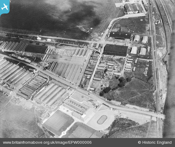
EPW000006 ENGLAND (1919). Aerodrome and Works, Hendon, 1919
© Copyright OpenStreetMap contributors and licensed by the OpenStreetMap Foundation. 2025. Cartography is licensed as CC BY-SA.
Nearby Images (26)
Details
| Title | [EPW000006] Aerodrome and Works, Hendon, 1919 |
| Reference | EPW000006 |
| Date | 26-July-1919 |
| Link | |
| Place name | HENDON |
| Parish | |
| District | |
| Country | ENGLAND |
| Easting / Northing | 522017, 189951 |
| Longitude / Latitude | -0.23826727338717, 51.59470170935 |
| National Grid Reference | TQ220900 |
Pins
 Mark Amies |
Wednesday 6th of August 2014 05:53:14 PM | |
 Mark Amies |
Wednesday 6th of August 2014 05:52:12 PM | |
 Mark Amies |
Wednesday 6th of August 2014 05:49:15 PM | |
 Mike Dean |
Saturday 2nd of August 2014 04:30:47 PM | |
That's a great photo Mike, I've only seen this building from Aerodrome Road behind hordings! Thanks for sharing. |
Katy Whitaker |
Thursday 7th of August 2014 01:43:03 PM |
 Mike Dean |
Saturday 2nd of August 2014 04:21:09 PM | |
 Mike Dean |
Saturday 2nd of August 2014 04:20:09 PM | |
 TomRobin |
Friday 25th of July 2014 01:48:57 PM |
User Comment Contributions
from Wikipedia: Hendon Aerodrome: In November 1916, the War Office commandeered the flying schools, after which the aerodrome trained 490 pilots. Claude Grahame-White and other members of the Royal Naval Air Service (RNAS) mounted a night defence of London in 1915, constituting the very first aerial defence of London. |
 TomRobin |
Saturday 2nd of August 2014 08:45:48 AM |
The road that runs left/right across the lower third of this photograph is Aerodrome Road. The main north/south railway line runs down the right hand side. The land and buildings south of Aerodrome Road became the training school for the Metropolitan Police. To the left of the oval is the flying club building which was in use as the canteen and residential accommodation for police recruits up to the 1970s. Immediately behind this building, are the hangers and workshops which were subsequently used as offices and classrooms. Into the 1970s Aerodrome Road continued to be a "Ministry of Defence Road" and was closed to the public on one day a year to retain its status as a private road. This was usually done on Christmas Day to minimise disruption to the local community. The police estate has been redeveloped and none of the original buildings remain. The area north of Aerodrome Road is now the location of the RAF Museum Hendon and a large housing estate. |
 Johno |
Saturday 2nd of August 2014 08:45:48 AM |


![[EPW000006] Aerodrome and Works, Hendon, 1919](http://britainfromabove.org.uk/sites/all/libraries/aerofilms-images/public/100x100/EPW/000/EPW000006.jpg)
![[EPW016606] Factories on the southern side of RAF Hendon and the London Country Club, Hendon, 1926](http://britainfromabove.org.uk/sites/all/libraries/aerofilms-images/public/100x100/EPW/016/EPW016606.jpg)
![[EPW016608] Factories on the southern side of RAF Hendon, the London Country Club and environs, Hendon, 1926](http://britainfromabove.org.uk/sites/all/libraries/aerofilms-images/public/100x100/EPW/016/EPW016608.jpg)
![[EPW016605] Factories on the southern side of RAF Hendon, Hendon, 1926](http://britainfromabove.org.uk/sites/all/libraries/aerofilms-images/public/100x100/EPW/016/EPW016605.jpg)
![[EPW016612] The London Country Club and factories on the southern side of RAF Hendon, Hendon, 1926](http://britainfromabove.org.uk/sites/all/libraries/aerofilms-images/public/100x100/EPW/016/EPW016612.jpg)
![[EPW016611] The London Country Club and factories on the southern side of RAF Hendon, Hendon, 1926](http://britainfromabove.org.uk/sites/all/libraries/aerofilms-images/public/100x100/EPW/016/EPW016611.jpg)
![[EPW016609] Factories on the southern side of RAF Hendon, Hendon, 1926](http://britainfromabove.org.uk/sites/all/libraries/aerofilms-images/public/100x100/EPW/016/EPW016609.jpg)
![[EPW006132] Aerofilms Ltd, Hendon, 1921](http://britainfromabove.org.uk/sites/all/libraries/aerofilms-images/public/100x100/EPW/006/EPW006132.jpg)
![[EPW016607] Factories on the southern side of RAF Hendon and the London Country Club, Hendon, 1926](http://britainfromabove.org.uk/sites/all/libraries/aerofilms-images/public/100x100/EPW/016/EPW016607.jpg)
![[EPW016610] The London Country Club and factories on the southern side of RAF Hendon, Hendon, 1926](http://britainfromabove.org.uk/sites/all/libraries/aerofilms-images/public/100x100/EPW/016/EPW016610.jpg)
![[EPW002008] The London Country Club, Hendon, 1920](http://britainfromabove.org.uk/sites/all/libraries/aerofilms-images/public/100x100/EPW/002/EPW002008.jpg)
![[EPR000650] Hendon Aerodrome, Colindale, 1935](http://britainfromabove.org.uk/sites/all/libraries/aerofilms-images/public/100x100/EPR/000/EPR000650.jpg)
![[EPW002008A] The London Country Club, Hendon, 1920. This image has been produced from a print.](http://britainfromabove.org.uk/sites/all/libraries/aerofilms-images/public/100x100/EPW/002/EPW002008A.jpg)
![[EPW009684] The London Country Club and aerodrome buildings, Hendon, 1923](http://britainfromabove.org.uk/sites/all/libraries/aerofilms-images/public/100x100/EPW/009/EPW009684.jpg)
![[EPW000014] London Country Club, Hendon, 1919](http://britainfromabove.org.uk/sites/all/libraries/aerofilms-images/public/100x100/EPW/000/EPW000014.jpg)
![[EPW002007] The London Country Club, Hendon, 1920](http://britainfromabove.org.uk/sites/all/libraries/aerofilms-images/public/100x100/EPW/002/EPW002007.jpg)
![[EPW007392] London Country Club, Aerodrome Road and Hendon Aerodrome, Colindale, from the south-east, 1921. This image has been produced from a copy-negative.](http://britainfromabove.org.uk/sites/all/libraries/aerofilms-images/public/100x100/EPW/007/EPW007392.jpg)
![[EPW000013] London Country Club, Hendon, 1919](http://britainfromabove.org.uk/sites/all/libraries/aerofilms-images/public/100x100/EPW/000/EPW000013.jpg)
![[EPW002011] The London Country Club, Hendon, from the north-east, 1920](http://britainfromabove.org.uk/sites/all/libraries/aerofilms-images/public/100x100/EPW/002/EPW002011.jpg)
![[EPW000009] London Country Club, Hendon, 1919](http://britainfromabove.org.uk/sites/all/libraries/aerofilms-images/public/100x100/EPW/000/EPW000009.jpg)
![[EPW002010] The London Country Club, Hendon, 1920](http://britainfromabove.org.uk/sites/all/libraries/aerofilms-images/public/100x100/EPW/002/EPW002010.jpg)
![[EPW000012] London Country Club, Hendon, 1919](http://britainfromabove.org.uk/sites/all/libraries/aerofilms-images/public/100x100/EPW/000/EPW000012.jpg)
![[EPW000001] London Country Club, Hendon, 1919](http://britainfromabove.org.uk/sites/all/libraries/aerofilms-images/public/100x100/EPW/000/EPW000001.jpg)
![[EPW008852] Factories on the southern side of RAF Hendon, Hendon, 1923](http://britainfromabove.org.uk/sites/all/libraries/aerofilms-images/public/100x100/EPW/008/EPW008852.jpg)
![[EPW000010] London Country Club, Hendon, 1919](http://britainfromabove.org.uk/sites/all/libraries/aerofilms-images/public/100x100/EPW/000/EPW000010.jpg)
![[EPW008760] RAF Pageant, Hendon, from the north, 1923](http://britainfromabove.org.uk/sites/all/libraries/aerofilms-images/public/100x100/EPW/008/EPW008760.jpg)

