
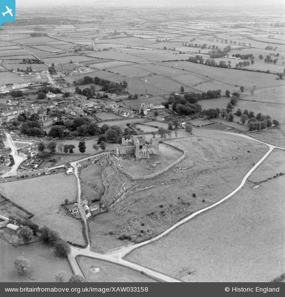
XAW033158 IRELAND (1950). Cashel Castle, Cashel, Tipperary, Ireland, 1950. Oblique aerial photograph taken facing South.
© Copyright OpenStreetMap contributors and licensed by the OpenStreetMap Foundation. 2026. Cartography is licensed as CC BY-SA.
Nearby Images (3)
XAW033158

XAW033160

XAW033156

Details
| Title | [XAW033158] Cashel Castle, Cashel, Tipperary, Ireland, 1950. Oblique aerial photograph taken facing South. |
| Reference | XAW033158 |
| Date | 1950 |
| Link | |
| Place name | CASHEL |
| Parish | IRELAND |
| District | |
| Country | IRELAND |
| Easting / Northing | 586, 307538 |
| Longitude / Latitude | -7.890311, 52.518828 |
| National Grid Reference |
Pins

John Swain |
Saturday 11th of October 2014 02:44:35 PM | |
|
John Swain |
Saturday 11th of October 2014 02:41:56 PM | |
|
John Swain |
Saturday 11th of October 2014 02:41:21 PM | |
|
John Swain |
Saturday 11th of October 2014 02:38:43 PM | |
|
John Swain |
Saturday 11th of October 2014 02:37:06 PM | |
|
John Swain |
Saturday 11th of October 2014 02:35:24 PM | |
|
John Swain |
Saturday 11th of October 2014 02:34:45 PM | |
|
John Swain |
Saturday 11th of October 2014 02:26:11 PM | |
|
John Swain |
Saturday 11th of October 2014 02:25:12 PM | |
|
John Swain |
Saturday 11th of October 2014 02:24:33 PM |
User Comment Contributions
Cashel is a small town of 2,800 when this photo was taken, a decline of about 400 people since 1936. The current figure is around 2,400. Industrial activity has been slight since the closure of the branch line railway in 1954 and the settlement has retained its undoubted charm as an historic centre popular with foreign visitors. The famous Rock of Cashel is 300 feet high on a massive limestone outcrop and is crowned with the remains of a castle, chapel and a round tower. In 1874 the ruins were handed over to the state, to be preseved as a National Monument. Cashel had been the ecclesiastical capital of Munster in medieval times. |
John Swain |
Saturday 11th of October 2014 03:01:13 PM |