
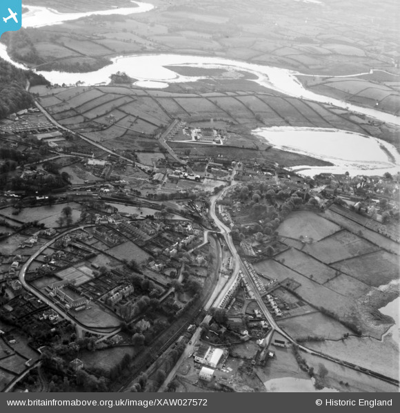
XAW027572 NORTHERN IRELAND (1949). Taylor Woods Ltd., Enniskillen, Fermanagh, Northern Ireland, 1949. Oblique aerial photograph taken facing South.
© Copyright OpenStreetMap contributors and licensed by the OpenStreetMap Foundation. 2026. Cartography is licensed as CC BY-SA.
Nearby Images (10)
XAW027572

XAW027562

XAW027559

XAW027566

XAW027563

XAW027570

XAW027560

XAW027564

XAW027567

XAW027561

Details
| Title | [XAW027572] Taylor Woods Ltd., Enniskillen, Fermanagh, Northern Ireland, 1949. Oblique aerial photograph taken facing South. |
| Reference | XAW027572 |
| Date | 2-November-1949 |
| Link | |
| Place name | ENNISKILLEN |
| Parish | NORTHERN IRELAND |
| District | |
| Country | NORTHERN IRELAND |
| Easting / Northing | 34104, 508392 |
| Longitude / Latitude | -7.632081, 54.339371 |
| National Grid Reference |
Pins

Ian |
Tuesday 19th of May 2026 04:57:50 PM | |
|
Ian |
Tuesday 19th of May 2026 04:56:18 PM | |
|
Ian |
Tuesday 19th of May 2026 04:50:57 PM | |
|
Ian |
Tuesday 19th of May 2026 04:49:47 PM | |
|
Ian |
Tuesday 19th of May 2026 04:47:22 PM | |
|
Ian |
Tuesday 19th of May 2026 04:46:13 PM | |
|
Ian |
Tuesday 19th of May 2026 04:43:54 PM | |
|
Ian |
Tuesday 19th of May 2026 04:38:32 PM | |
|
Ian |
Tuesday 19th of May 2026 04:31:49 PM | |
|
Ian |
Tuesday 19th of May 2026 04:27:53 PM | |
|
Ian |
Tuesday 19th of May 2026 04:27:27 PM | |
|
Ian |
Tuesday 19th of May 2026 04:25:42 PM | |
|
Ian |
Tuesday 19th of May 2026 04:24:42 PM | |
|
Ian |
Tuesday 19th of May 2026 04:24:08 PM | |
|
Ian |
Tuesday 19th of May 2026 03:53:36 PM | |
|
Ian |
Tuesday 19th of May 2026 03:52:32 PM | |
|
Ian |
Tuesday 19th of May 2026 03:51:32 PM | |
|
Ian |
Tuesday 19th of May 2026 03:50:18 PM | |
|
Ian |
Tuesday 19th of May 2026 03:48:35 PM | |
|
Ian |
Tuesday 19th of May 2026 03:08:48 PM | |
|
Ian |
Tuesday 19th of May 2026 02:53:58 PM | |
|
Ian |
Tuesday 19th of May 2026 02:53:40 PM | |
|
Ian |
Tuesday 19th of May 2026 02:50:05 PM | |
|
IntrepidExplorer82 |
Friday 1st of January 2021 02:58:25 PM | |
|
IntrepidExplorer82 |
Friday 1st of January 2021 02:44:10 PM | |
|
IntrepidExplorer82 |
Friday 1st of January 2021 02:40:21 PM | |
|
IntrepidExplorer82 |
Friday 1st of January 2021 02:19:26 PM | |
|
IntrepidExplorer82 |
Friday 1st of January 2021 02:17:35 PM | |

Billy Turner |
Thursday 10th of September 2015 08:15:27 PM |
