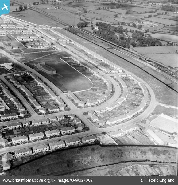
XAW027002 IRELAND (1949). Bannon Road, Dublin, Dublin, Ireland, 1949. Oblique aerial photograph taken facing North.
© Copyright OpenStreetMap contributors and licensed by the OpenStreetMap Foundation. 2026. Cartography is licensed as CC BY-SA.
Nearby Images (12)
Details
| Title | [XAW027002] Bannon Road, Dublin, Dublin, Ireland, 1949. Oblique aerial photograph taken facing North. |
| Reference | XAW027002 |
| Date | 30-September-1949 |
| Link | |
| Place name | DUBLIN |
| Parish | IRELAND |
| District | |
| Country | IRELAND |
| Easting / Northing | 114634, 394526 |
| Longitude / Latitude | -6.291459, 53.370324 |
| National Grid Reference |
Pins

David Doyle |
Friday 1st of December 2017 05:06:22 PM |


![[XAW027002] Bannon Road, Dublin, Dublin, Ireland, 1949. Oblique aerial photograph taken facing North.](http://britainfromabove.org.uk/sites/all/libraries/aerofilms-images/public/100x100/XAW/027/XAW027002.jpg)
![[XAW027001] Bannon Road, Dublin, Dublin, Ireland, 1949. Oblique aerial photograph taken facing West.](http://britainfromabove.org.uk/sites/all/libraries/aerofilms-images/public/100x100/XAW/027/XAW027001.jpg)
![[XAW026998] Batchalor & Co. (I) Ltd., Dublin, Dublin, Ireland, 1949. Oblique aerial photograph taken facing South/East. This image was marked by Aerofilms Ltd for photo editing.](http://britainfromabove.org.uk/sites/all/libraries/aerofilms-images/public/100x100/XAW/026/XAW026998.jpg)
![[XAW026996] Batchalor & Co. (I) Ltd., Dublin, Dublin, Ireland, 1949. Oblique aerial photograph taken facing East. This image was marked by Aerofilms Ltd for photo editing.](http://britainfromabove.org.uk/sites/all/libraries/aerofilms-images/public/100x100/XAW/026/XAW026996.jpg)
![[XAW027000] Batchalor & Co. (I) Ltd., Dublin, Dublin, Ireland, 1949. Oblique aerial photograph taken facing South/East. This image was marked by Aerofilms Ltd for photo editing.](http://britainfromabove.org.uk/sites/all/libraries/aerofilms-images/public/100x100/XAW/027/XAW027000.jpg)
![[XAW027005] Bannon Road, Dublin, Dublin, Ireland, 1949. Oblique aerial photograph taken facing North/West.](http://britainfromabove.org.uk/sites/all/libraries/aerofilms-images/public/100x100/XAW/027/XAW027005.jpg)
![[XAW026995] Batchalor & Co. (I) Ltd., Dublin, Dublin, Ireland, 1949. Oblique aerial photograph taken facing North/East. This image was marked by Aerofilms Ltd for photo editing and has been produced from a damaged negative.](http://britainfromabove.org.uk/sites/all/libraries/aerofilms-images/public/100x100/XAW/026/XAW026995.jpg)
![[XAW026994] Batohalor and Co Ltd, Bannow Road, Dublin, Dublin, Ireland, 1949. Oblique aerial photograph taken facing North/East. This image was marked by Aerofilms Ltd for photo editing.](http://britainfromabove.org.uk/sites/all/libraries/aerofilms-images/public/100x100/XAW/026/XAW026994.jpg)
![[XAW026997] Batchalor & Co. (I) Ltd., Dublin, Dublin, Ireland, 1949. Oblique aerial photograph taken facing North. This image was marked by Aerofilms Ltd for photo editing.](http://britainfromabove.org.uk/sites/all/libraries/aerofilms-images/public/100x100/XAW/026/XAW026997.jpg)
![[XAW027006] Bannon Road, Dublin, Dublin, Ireland, 1949. Oblique aerial photograph taken facing North/West.](http://britainfromabove.org.uk/sites/all/libraries/aerofilms-images/public/100x100/XAW/027/XAW027006.jpg)
![[XAW027003] Bannon Road, Dublin, Dublin, Ireland, 1949. Oblique aerial photograph taken facing West.](http://britainfromabove.org.uk/sites/all/libraries/aerofilms-images/public/100x100/XAW/027/XAW027003.jpg)
![[XAW026999] Batchalor & Co. (I) Ltd., Dublin, Dublin, Ireland, 1949. Oblique aerial photograph taken facing South/West. This image was marked by Aerofilms Ltd for photo editing.](http://britainfromabove.org.uk/sites/all/libraries/aerofilms-images/public/100x100/XAW/026/XAW026999.jpg)