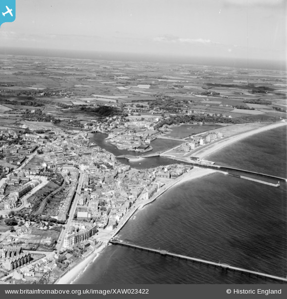
XAW023422 ISLE OF MAN (1949). General View, Ramsey, Isle of Man, Isle of Man, 1949. Oblique aerial photograph taken facing North/West.
© Copyright OpenStreetMap contributors and licensed by the OpenStreetMap Foundation. 2026. Cartography is licensed as CC BY-SA.
Details
| Title | [XAW023422] General View, Ramsey, Isle of Man, Isle of Man, 1949. Oblique aerial photograph taken facing North/West. |
| Reference | XAW023422 |
| Date | 26-May-1949 |
| Link | |
| Place name | RAMSEY |
| Parish | ISLE OF MAN |
| District | |
| Country | ISLE OF MAN |
| Easting / Northing | 245383, 494369 |
| Longitude / Latitude | -4.378763, 54.321423 |
| National Grid Reference |
Pins

John Hitchen |
Sunday 3rd of November 2024 01:32:19 PM | |

matt |
Wednesday 8th of April 2020 06:06:16 PM | |

matt |
Wednesday 19th of July 2017 01:18:54 PM | |

Arthur |
Thursday 17th of March 2016 09:47:08 PM | |

Arthur |
Wednesday 16th of March 2016 10:12:30 AM | |

Arthur |
Wednesday 16th of March 2016 10:10:43 AM | |

Maitland |
Sunday 26th of October 2014 02:15:15 PM | |

John Swain |
Friday 17th of October 2014 02:52:57 PM | |

John Swain |
Friday 17th of October 2014 02:52:05 PM | |

John Swain |
Friday 17th of October 2014 02:51:26 PM | |

John Swain |
Friday 17th of October 2014 02:50:41 PM | |

John Swain |
Friday 17th of October 2014 02:49:50 PM | |

John Swain |
Friday 17th of October 2014 02:48:38 PM | |

John Swain |
Friday 17th of October 2014 02:47:51 PM | |

John Swain |
Friday 17th of October 2014 02:46:05 PM | |

John Swain |
Friday 17th of October 2014 02:43:32 PM | |

John Swain |
Friday 17th of October 2014 02:42:45 PM | |

John Swain |
Friday 17th of October 2014 02:40:32 PM | |

John Swain |
Friday 17th of October 2014 02:33:58 PM | |

John Swain |
Friday 17th of October 2014 02:32:15 PM | |

John Swain |
Friday 17th of October 2014 02:30:00 PM | |

John Swain |
Friday 17th of October 2014 02:29:16 PM | |

John Swain |
Friday 17th of October 2014 02:28:15 PM | |

John Swain |
Friday 17th of October 2014 02:27:49 PM | |

John Swain |
Friday 17th of October 2014 02:27:12 PM | |

John Swain |
Friday 17th of October 2014 02:26:42 PM | |

John Wass |
Friday 26th of September 2014 09:09:24 PM | |

John Wass |
Friday 26th of September 2014 09:07:29 PM |
User Comment Contributions
Ramsey, until very recently, was the second-largest town on the island, with 7,322 inhabitants in 2001, compared with 4,642 in 1931. It has a wonderful setting on the 10-mile sweep of Ramsey Bay, whose sandy shoreline extends north to the Point of Ayre. The town functions as a coastguard and lifeboat station, as well as a small port for the north of the island. Ramsey also hosts several annual sporting and cultural events, and is a popular destination for tourists. |

John Swain |
Friday 17th of October 2014 03:03:38 PM |


![[XAW023422] General View, Ramsey, Isle of Man, Isle of Man, 1949. Oblique aerial photograph taken facing North/West.](http://britainfromabove.org.uk/sites/all/libraries/aerofilms-images/public/100x100/XAW/023/XAW023422.jpg)
![[XAW023424] General View, Ramsey, Isle of Man, Isle of Man, 1949. Oblique aerial photograph taken facing East.](http://britainfromabove.org.uk/sites/all/libraries/aerofilms-images/public/100x100/XAW/023/XAW023424.jpg)
![[XAW023423] General View, Ramsey, Isle of Man, Isle of Man, 1949. Oblique aerial photograph taken facing South.](http://britainfromabove.org.uk/sites/all/libraries/aerofilms-images/public/100x100/XAW/023/XAW023423.jpg)