
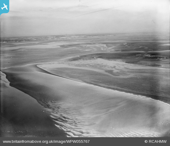
WPW055767 WALES (1937). View of sea of Mostyn, Flintshire, oblique aerial view. 5"x4" black and white glass plate negative.
© Copyright OpenStreetMap contributors and licensed by the OpenStreetMap Foundation. 2026. Cartography is licensed as CC BY-SA.
Nearby Images (17)
WPW045134

WPW045135

WPW045136

WPW045137

WPW045138

WPW045139

WPW045140

WPW045141

WPW045142

WPW045150

WPW045151

WPW045152

WPW045153

WPW045154

WPW045155

WPW045156

WPW055767

Details
| Title | [WPW055767] View of sea of Mostyn, Flintshire, oblique aerial view. 5"x4" black and white glass plate negative. |
| Reference | WPW055767 |
| Date | 30-September-1937 |
| Link | Coflein Archive Item 6370419 |
| Place name | |
| Parish | |
| District | |
| Country | WALES |
| Easting / Northing | 316070, 380330 |
| Longitude / Latitude | -3.2599052538566, 53.312973713924 |
| National Grid Reference | SJ161803 |
Pins

Class31 |
Tuesday 19th of November 2013 11:06:24 AM | |
|
Class31 |
Tuesday 19th of November 2013 11:01:57 AM | |
|
Class31 |
Tuesday 19th of November 2013 10:51:03 AM | |
|
Class31 |
Tuesday 19th of November 2013 10:33:48 AM | |
|
Class31 |
Tuesday 19th of November 2013 10:21:32 AM | |
|
Class31 |
Tuesday 19th of November 2013 10:17:58 AM | |
|
Class31 |
Wednesday 22nd of August 2012 11:56:14 AM | |

roger freeman |
Sunday 1st of July 2012 01:20:52 AM | |
Not sure. The angle doesnt seem right. It looks as if its looking from Grange over sands, looking out of the Bay with Morecambe on the left? If you were standing in Barrow would you see the other side as well as that? |
SteveAUS |
Thursday 5th of July 2012 06:58:24 AM |
It would help if you delete your pin tab. The picture's location has now been identified. It is of the Dee Estuary, not Morecambe Bay. What you have clicked on is most likely Bagillt Bank. |
Bunn72 |
Monday 20th of January 2014 01:17:10 PM |
User Comment Contributions
Eureka I think that I have sufficient confidence to suggest that this is a photograph looking east from over Greenfield towards Neston on the Wirral. I believe that I can identify Mostyn House School in Parkgate. The River Dee/Afon Dyfrdwy estuary in the foreground looks a good fit and the long expanses of salt marsh in front of Parkgate fits well. There is a church with a tower which fits well for St. Mary and St. Helen, Neston. There is a line of newish houses which could be Burton Road, Neston. I have looked at many other locations and I believe this to be the best fit so far. |
Class31 |
Tuesday 19th of November 2013 10:42:17 AM |
I am not happy with this deduction, on the 1937 ord survey Parkgate is terraced houses and has other houses and a railway in front, also there is no sign of Little Neston or the railway on an embankment |
TomRobin |
Saturday 4th of May 2013 09:32:56 AM |
I am not sure of this location because of the extreme distances to anything which might be identifiable. For the present I suggest that we disregard the identification which I have suggested. |
Class31 |
Saturday 4th of May 2013 10:39:17 AM |
I have had another look at this photo, because I like to resolve matters. I have identified a few more features on the far side of the Dee Estuary in England such that I feel I can once again advance the view that the features in the distance are of the Neston area. I have shifted the pin for this photo to Neston in England because all the,possibly, identifiable features are in England and this will ensure that Katy gives this her scrutiny. Meanwhile I shall beaver away putting a few more pins in the picture. I am much more confident now. |
Class31 |
Tuesday 19th of November 2013 10:42:17 AM |
View looking east. |
Class31 |
Tuesday 19th of November 2013 10:22:40 AM |
Given that it is marked as a shot of Wales and the photo's near it in sequence are of Conwy. I think this might be a shot across the Lavan sands of the Menai straight probably taken from over Abergwyngregyn towards Beaumaris - but not having any local knowledge of the low water sand banks I cant be certain |
Dave Brunt |
Tuesday 7th of August 2012 08:45:38 PM |