
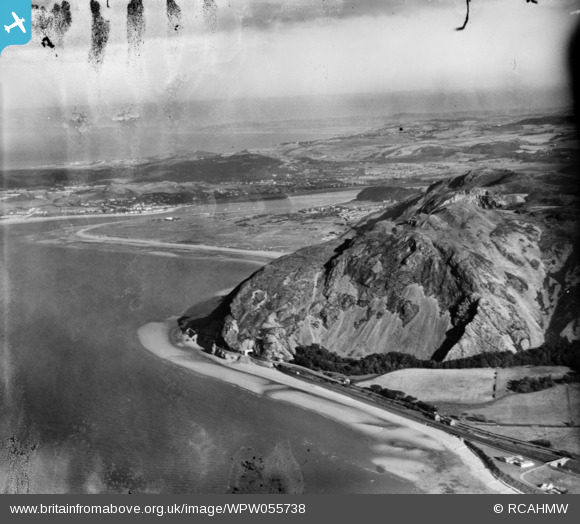
WPW055738 WALES (1937). Distant view of Penmaenmawr, oblique aerial view. 5"x4" black and white glass plate negative.
© Copyright OpenStreetMap contributors and licensed by the OpenStreetMap Foundation. 2025. Cartography is licensed as CC BY-SA.
Nearby Images (21)
WAW010001

WAW010002

WAW010003

WAW010006

WAW010007

WAW010008

WAW010010

WAW010011

WAW010484

WAW010485

WAW010486

WAW017362

WPW040136

WPW040137

WPW040138

WPW040139

WPW045177

WPW045178

WPW045179

WPW045180

WPW055738

Details
| Title | [WPW055738] Distant view of Penmaenmawr, oblique aerial view. 5"x4" black and white glass plate negative. |
| Reference | WPW055738 |
| Date | 30-September-1937 |
| Link | Coflein Archive Item 6370194 |
| Place name | |
| Parish | |
| District | |
| Country | WALES |
| Easting / Northing | 271000, 376000 |
| Longitude / Latitude | -3.9343604965008, 53.265009852739 |
| National Grid Reference | SH710760 |
Pins

Bunn72 |
Sunday 16th of June 2013 10:33:55 PM | |

Class31 |
Wednesday 31st of October 2012 10:38:46 AM | |
|
Class31 |
Wednesday 31st of October 2012 10:37:04 AM | |
|
Class31 |
Wednesday 31st of October 2012 10:36:08 AM | |
|
Class31 |
Wednesday 31st of October 2012 10:35:40 AM | |
|
MB |
Friday 19th of October 2012 10:04:00 PM | |
|
MB |
Friday 19th of October 2012 10:03:20 PM | |
|
MB |
Friday 19th of October 2012 10:02:49 PM |
User Comment Contributions
Photo is of Penmaenbach looking east over the mouth of the Afon Conwy towards Deganwy and Cyffordd Llandudno Junction. |
Class31 |
Wednesday 31st of October 2012 10:42:18 AM |