
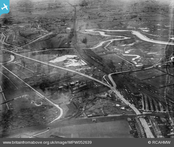
WPW052639 WALES (1937). View of Cardiff showing the area near Rumney and Pengam Moor, oblique aerial view. 5"x4" black and white glass plate negative.
© Copyright OpenStreetMap contributors and licensed by the OpenStreetMap Foundation. 2026. Cartography is licensed as CC BY-SA.
Nearby Images (48)
WPW000947

WPW000949

WPW000951

WPW000952

WPW000953

WPW000954

WPW022280

WPW022281

WPW022284

WPW022285

WPW022286

WPW029303

WPW029304

WPW029305

WPW029306

WPW029307

WPW029309

WPW029313

WPW032457

WPW032458

WPW032459

WPW032460

WPW032461

WPW032462

WPW032463

WPW052620

WPW052621

WPW052622

WPW052626

WPW052629

WPW052632

WPW052634

WPW052639

WPW052641

WPW052643

WPW052644

WPW052645

WPW052646

WPW052648

WPW052649

WPW052650

WPW052652

WPW052653

WPW052654

WPW052655

WPW052656

WPW052657

WPW052658

Details
| Title | [WPW052639] View of Cardiff showing the area near Rumney and Pengam Moor, oblique aerial view. 5"x4" black and white glass plate negative. |
| Reference | WPW052639 |
| Date | 1937 |
| Link | Coflein Archive Item 6370060 |
| Place name | |
| Parish | |
| District | |
| Country | WALES |
| Easting / Northing | 331010, 188330 |
| Longitude / Latitude | -2.9959602652742, 51.589120636107 |
| National Grid Reference | ST310883 |
Pins

Welshtraveler |
Sunday 21st of October 2012 01:18:11 AM | |
|
Welshtraveler |
Sunday 21st of October 2012 01:14:36 AM | |
|
Welshtraveler |
Sunday 21st of October 2012 01:07:18 AM | |
|
Welshtraveler |
Sunday 21st of October 2012 01:05:23 AM | |
|
hjr |
Friday 29th of June 2012 08:08:49 PM |
User Comment Contributions
electric power station to power the tram depot next door in centre of photo Massive railway sidings right across the foreground and across the centre towards Newport. Newport road (the common) in the centre with large ponds, clay extracted for Rumney Pottery I think. First factory on the common was Farmers and Dairymen(Rumney end) recently demolished |
wentlooge |
Wednesday 27th of June 2012 05:05:19 PM |