
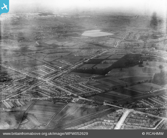
WPW052629 WALES (1937). View near Cardiff showing parts of Llanishen and Whitchurch, oblique aerial view. 5"x4" black and white glass plate negative.
© Copyright OpenStreetMap contributors and licensed by the OpenStreetMap Foundation. 2026. Cartography is licensed as CC BY-SA.
Nearby Images (48)
WPW000947

WPW000949

WPW000951

WPW000952

WPW000953

WPW000954

WPW022280

WPW022281

WPW022284

WPW022285

WPW022286

WPW029303

WPW029304

WPW029305

WPW029306

WPW029307

WPW029309

WPW029313

WPW032457

WPW032458

WPW032459

WPW032460

WPW032461

WPW032462

WPW032463

WPW052620

WPW052621

WPW052622

WPW052626

WPW052629

WPW052632

WPW052634

WPW052639

WPW052641

WPW052643

WPW052644

WPW052645

WPW052646

WPW052648

WPW052649

WPW052650

WPW052652

WPW052653

WPW052654

WPW052655

WPW052656

WPW052657

WPW052658

Details
| Title | [WPW052629] View near Cardiff showing parts of Llanishen and Whitchurch, oblique aerial view. 5"x4" black and white glass plate negative. |
| Reference | WPW052629 |
| Date | 1937 |
| Link | Coflein Archive Item 6370050 |
| Place name | |
| Parish | |
| District | |
| Country | WALES |
| Easting / Northing | 331010, 188330 |
| Longitude / Latitude | -2.9959602652742, 51.589120636107 |
| National Grid Reference | ST310883 |
Pins

Chris G |
Saturday 11th of April 2020 04:46:51 PM | |
|
mark |
Thursday 14th of March 2013 11:21:31 PM | |
|
mark |
Thursday 14th of March 2013 11:15:39 PM | |
|
mark |
Thursday 14th of March 2013 11:14:19 PM | |
|
mark |
Thursday 14th of March 2013 11:12:42 PM | |
|
mark |
Thursday 14th of March 2013 11:10:07 PM | |
|
ERICA |
Saturday 21st of July 2012 04:25:28 PM | |
|
ERICA |
Saturday 21st of July 2012 04:23:24 PM | |
|
ERICA |
Saturday 21st of July 2012 04:21:45 PM | |
|
Griff |
Sunday 1st of July 2012 06:54:48 PM | |
|
Griff |
Sunday 1st of July 2012 06:54:24 PM | |
|
HPSauce |
Wednesday 27th of June 2012 05:32:27 PM | |
|
HPSauce |
Wednesday 27th of June 2012 05:22:36 PM | |
|
JP1000 |
Wednesday 27th of June 2012 11:54:01 AM | |
|
JP1000 |
Wednesday 27th of June 2012 11:53:23 AM | |
|
JP1000 |
Wednesday 27th of June 2012 11:42:36 AM | |
|
peterg |
Wednesday 27th of June 2012 07:56:35 AM |
User Comment Contributions

Cardiff courtesy of Bing Maps |
JP1000 |
Wednesday 27th of June 2012 05:37:02 PM |
Well spotted Gareth, looks like Birchrove Rd, leading into Heathwood Rd running from bottom left diagonally to the right, eventually leading into Rhyd-y-Penau Rd past the reservoirs. Using max magnification I think I can just make out "The Birch" pub at Caerphilly Rd / Heathwood Rd junction!! I think it's mid 30's as the house where my parents lived is visible and that was built about that time |
JP1000 |
Tuesday 26th of June 2012 08:47:06 PM |
This is northern Cardiff, before 1939 as my old house is not visible. Most of Whitchurch is off to the left; the prominent white road is Western Avenue, joining North Road; Caerphilly Road runs off to the upper left. Llanishen reservoirs are in the distance. |
Gareth |
Monday 25th of June 2012 08:59:52 PM |