
WPW052627 WALES (1937). View of Cardiff Airport, Splott, oblique aerial view. 5"x4" black and white glass plate negative.

© Copyright OpenStreetMap contributors and licensed by the OpenStreetMap Foundation. 2026. Cartography is licensed as CC BY-SA.
Nearby Images (5)
WPW045746

WPW045747

WPW052627

WPW052640

WPW052642

Details
| Title | [WPW052627] View of Cardiff Airport, Splott, oblique aerial view. 5"x4" black and white glass plate negative. |
| Reference | WPW052627 |
| Date | 1937 |
| Link | Coflein Archive Item 6370048 |
| Place name | |
| Parish | |
| District | |
| Country | WALES |
| Easting / Northing | 321500, 177000 |
| Longitude / Latitude | -3.1306951607918, 51.486011082353 |
| National Grid Reference | ST215770 |
Pins

David Jones |
Thursday 21st of May 2020 12:09:08 AM | |
|
gerry-r |
Friday 11th of July 2014 11:50:50 PM | |
|
gerry-r |
Friday 11th of July 2014 11:45:52 PM | |
|
hjr |
Wednesday 8th of January 2014 12:30:29 AM | |
|
hjr |
Wednesday 8th of January 2014 12:29:04 AM |
User Comment Contributions
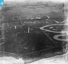
Cardiff Airport the old RAF and civil flying airport as it was in Pengham Moors, Splott, before it was moved to it's current location in Rhoose. |
KimberlyBriscoe |
Monday 16th of December 2013 04:56:54 PM |
Pengam Moors Airport. Cardiff's airport until it moved to Rhoose in the 1950's |
Capt Vance F Burton |
Monday 8th of October 2012 09:35:04 PM |