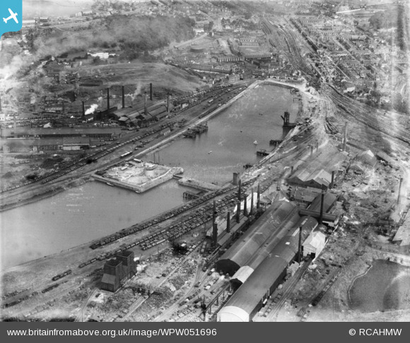
WPW051696 WALES (1936). View of Briton Ferry showing the docks and steelworks, oblique aerial view. 5"x4" black and white glass plate negative.
© Copyright OpenStreetMap contributors and licensed by the OpenStreetMap Foundation. 2025. Cartography is licensed as CC BY-SA.
Nearby Images (32)
Details
| Title | [WPW051696] View of Briton Ferry showing the docks and steelworks, oblique aerial view. 5"x4" black and white glass plate negative. |
| Reference | WPW051696 |
| Date | 1936 |
| Link | Coflein Archive Item 6370031 |
| Place name | |
| Parish | |
| District | |
| Country | WALES |
| Easting / Northing | 273820, 194280 |
| Longitude / Latitude | -3.8233664833531, 51.632692570596 |
| National Grid Reference | SS738943 |


![[WAW034026] View of the Cleveland Bridge & Engineering Co. Ltd. Bridge under construction at Briton Ferry. Oblique aerial photograph, 5½" cut roll film.](http://britainfromabove.org.uk/sites/all/libraries/aerofilms-images/public/100x100/WAW/034/WAW034026.jpg)
![[WAW034027] View of the Cleveland Bridge & Engineering Co. Ltd. bridge under construction at Briton Ferry. Oblique aerial photograph, 5½" cut roll film.](http://britainfromabove.org.uk/sites/all/libraries/aerofilms-images/public/100x100/WAW/034/WAW034027.jpg)
![[WAW034028] View of the Cleveland Bridge & Engineering Co. Ltd. bridge under construction at Briton Ferry. Oblique aerial photograph, 5½" cut roll film.](http://britainfromabove.org.uk/sites/all/libraries/aerofilms-images/public/100x100/WAW/034/WAW034028.jpg)
![[WAW034029] View of the Cleveland Bridge & Engineering Co. Ltd. bridge under construction at Briton Ferry. Oblique aerial photograph, 5½" cut roll film.](http://britainfromabove.org.uk/sites/all/libraries/aerofilms-images/public/100x100/WAW/034/WAW034029.jpg)
![[WAW034030] View of Briton Ferry and the Cleveland Bridge under construction. Oblique aerial photograph, 5½" cut roll film.](http://britainfromabove.org.uk/sites/all/libraries/aerofilms-images/public/100x100/WAW/034/WAW034030.jpg)
![[WAW034031] View of Briton Ferry and the Cleveland Bridge under construction. Oblique aerial photograph, 5½" cut roll film.](http://britainfromabove.org.uk/sites/all/libraries/aerofilms-images/public/100x100/WAW/034/WAW034031.jpg)
![[WAW034032] View of Briton Ferry and the Cleveland Bridge under construction. Oblique aerial photograph, 5½" cut roll film.](http://britainfromabove.org.uk/sites/all/libraries/aerofilms-images/public/100x100/WAW/034/WAW034032.jpg)
![[WAW034033] View of Briton Ferry and the Cleveland Bridge under construction. Oblique aerial photograph, 5½" cut roll film.](http://britainfromabove.org.uk/sites/all/libraries/aerofilms-images/public/100x100/WAW/034/WAW034033.jpg)
![[WAW034034] View of Briton Ferry and the Cleveland Bridge under construction. Oblique aerial photograph, 5½" cut roll film.](http://britainfromabove.org.uk/sites/all/libraries/aerofilms-images/public/100x100/WAW/034/WAW034034.jpg)
![[WAW034035] View of Briton Ferry and the Cleveland Bridge under construction. Oblique aerial photograph, 5½" cut roll film.](http://britainfromabove.org.uk/sites/all/libraries/aerofilms-images/public/100x100/WAW/034/WAW034035.jpg)
![[WAW034036] View of Briton Ferry and the Cleveland Bridge under construction. Oblique aerial photograph, 5½" cut roll film.](http://britainfromabove.org.uk/sites/all/libraries/aerofilms-images/public/100x100/WAW/034/WAW034036.jpg)
![[WAW034037] View of Briton Ferry and the Cleveland Bridge under construction. Oblique aerial photograph, 5½" cut roll film.](http://britainfromabove.org.uk/sites/all/libraries/aerofilms-images/public/100x100/WAW/034/WAW034037.jpg)
![[WAW034038] View of Briton Ferry and the Cleveland Bridge under construction. Oblique aerial photograph, 5½" cut roll film.](http://britainfromabove.org.uk/sites/all/libraries/aerofilms-images/public/100x100/WAW/034/WAW034038.jpg)
![[WAW034039] View of Briton Ferry and the Cleveland Bridge under construction. Oblique aerial photograph, 5½" cut roll film.](http://britainfromabove.org.uk/sites/all/libraries/aerofilms-images/public/100x100/WAW/034/WAW034039.jpg)
![[WAW034040] View of Briton Ferry and the Cleveland Bridge under construction. Oblique aerial photograph, 5½" cut roll film.](http://britainfromabove.org.uk/sites/all/libraries/aerofilms-images/public/100x100/WAW/034/WAW034040.jpg)
![[WAW034041] View of Briton Ferry and the Cleveland Bridge under construction. Oblique aerial photograph, 5½" cut roll film.](http://britainfromabove.org.uk/sites/all/libraries/aerofilms-images/public/100x100/WAW/034/WAW034041.jpg)
![[WAW034042] View of Briton Ferry and the Cleveland Bridge under construction. Oblique aerial photograph, 5½" cut roll film.](http://britainfromabove.org.uk/sites/all/libraries/aerofilms-images/public/100x100/WAW/034/WAW034042.jpg)
![[WAW034043] View of Briton Ferry and the Cleveland Bridge under construction. Oblique aerial photograph, 5½" cut roll film.](http://britainfromabove.org.uk/sites/all/libraries/aerofilms-images/public/100x100/WAW/034/WAW034043.jpg)
![[WAW034044] View of Briton Ferry and the Cleveland Bridge under construction. Oblique aerial photograph, 5½" cut roll film.](http://britainfromabove.org.uk/sites/all/libraries/aerofilms-images/public/100x100/WAW/034/WAW034044.jpg)
![[WAW034045] View of Briton Ferry and the Cleveland Bridge under construction. Oblique aerial photograph, 5½" cut roll film.](http://britainfromabove.org.uk/sites/all/libraries/aerofilms-images/public/100x100/WAW/034/WAW034045.jpg)
![[WAW034046] View of Briton Ferry and the Cleveland Bridge under construction. Oblique aerial photograph, 5½" cut roll film.](http://britainfromabove.org.uk/sites/all/libraries/aerofilms-images/public/100x100/WAW/034/WAW034046.jpg)
![[WPW006118] View of Briton Ferry showing docks, oblique aerial view. 5"x4" black and white glass plate negative.](http://britainfromabove.org.uk/sites/all/libraries/aerofilms-images/public/100x100/WPW/006/WPW006118.jpg)
![[WPW006119] View of Briton Ferry showing docks, oblique aerial view. 5"x4" black and white glass plate negative.](http://britainfromabove.org.uk/sites/all/libraries/aerofilms-images/public/100x100/WPW/006/WPW006119.jpg)
![[WPW051688] View of Briton Ferry showing the docks, oblique aerial view. 5"x4" black and white glass plate negative.](http://britainfromabove.org.uk/sites/all/libraries/aerofilms-images/public/100x100/WPW/051/WPW051688.jpg)
![[WPW051689] View of Briton Ferry showing the docks and steelworks, oblique aerial view. 5"x4" black and white glass plate negative.](http://britainfromabove.org.uk/sites/all/libraries/aerofilms-images/public/100x100/WPW/051/WPW051689.jpg)
![[WPW051690] View of Briton Ferry showing the docks and steelworks, oblique aerial view. 5"x4" black and white glass plate negative.](http://britainfromabove.org.uk/sites/all/libraries/aerofilms-images/public/100x100/WPW/051/WPW051690.jpg)
![[WPW051691] View of Briton Ferry showing the docks and steelworks, oblique aerial view. 5"x4" black and white glass plate negative.](http://britainfromabove.org.uk/sites/all/libraries/aerofilms-images/public/100x100/WPW/051/WPW051691.jpg)
![[WPW051692] View of Briton Ferry showing the docks and steelworks, oblique aerial view. 5"x4" black and white glass plate negative.](http://britainfromabove.org.uk/sites/all/libraries/aerofilms-images/public/100x100/WPW/051/WPW051692.jpg)
![[WPW051693] View of Briton Ferry showing the docks and steelworks, oblique aerial view. 5"x4" black and white glass plate negative.](http://britainfromabove.org.uk/sites/all/libraries/aerofilms-images/public/100x100/WPW/051/WPW051693.jpg)
![[WPW051694] View of Briton Ferry showing the docks and steelworks, oblique aerial view. 5"x4" black and white glass plate negative.](http://britainfromabove.org.uk/sites/all/libraries/aerofilms-images/public/100x100/WPW/051/WPW051694.jpg)
![[WPW051695] View of Briton Ferry showing the docks and steelworks, oblique aerial view. 5"x4" black and white glass plate negative.](http://britainfromabove.org.uk/sites/all/libraries/aerofilms-images/public/100x100/WPW/051/WPW051695.jpg)
![[WPW051696] View of Briton Ferry showing the docks and steelworks, oblique aerial view. 5"x4" black and white glass plate negative.](http://britainfromabove.org.uk/sites/all/libraries/aerofilms-images/public/100x100/WPW/051/WPW051696.jpg)
