
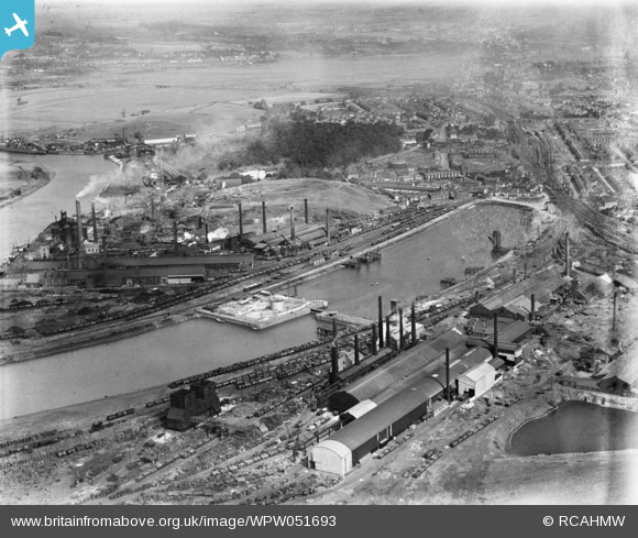
WPW051693 WALES (1936). View of Briton Ferry showing the docks and steelworks, oblique aerial view. 5"x4" black and white glass plate negative.
© Copyright OpenStreetMap contributors and licensed by the OpenStreetMap Foundation. 2025. Cartography is licensed as CC BY-SA.
Nearby Images (32)
WAW034026

WAW034027

WAW034028

WAW034029

WAW034030

WAW034031

WAW034032

WAW034033

WAW034034

WAW034035

WAW034036

WAW034037

WAW034038

WAW034039

WAW034040

WAW034041

WAW034042

WAW034043

WAW034044

WAW034045

WAW034046

WPW006118

WPW006119

WPW051688

WPW051689

WPW051690

WPW051691

WPW051692

WPW051693

WPW051694

WPW051695

WPW051696

Details
| Title | [WPW051693] View of Briton Ferry showing the docks and steelworks, oblique aerial view. 5"x4" black and white glass plate negative. |
| Reference | WPW051693 |
| Date | 1936 |
| Link | Coflein Archive Item 6370028 |
| Place name | |
| Parish | |
| District | |
| Country | WALES |
| Easting / Northing | 273820, 194280 |
| Longitude / Latitude | -3.8233664833531, 51.632692570596 |
| National Grid Reference | SS738943 |
Pins

Class31 |
Monday 17th of November 2014 12:02:19 PM | |
|
Class31 |
Thursday 11th of October 2012 10:48:57 PM | |
|
Class31 |
Thursday 11th of October 2012 10:38:25 PM | |
|
Class31 |
Thursday 11th of October 2012 10:35:53 PM | |
|
Class31 |
Thursday 11th of October 2012 10:31:10 PM | |
|
Class31 |
Thursday 11th of October 2012 10:29:51 PM | |
|
Class31 |
Thursday 11th of October 2012 10:00:49 PM |
