
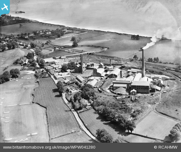
WPW041280 WALES (1933). View of Portland cement and lime works, Penarth, oblique aerial view. 5"x4" black and white glass plate negative.
© Copyright OpenStreetMap contributors and licensed by the OpenStreetMap Foundation. 2026. Cartography is licensed as CC BY-SA.
Nearby Images (3)
WPW041280

WPW041281

WPW041282

Details
| Title | [WPW041280] View of Portland cement and lime works, Penarth, oblique aerial view. 5"x4" black and white glass plate negative. |
| Reference | WPW041280 |
| Date | 1933 |
| Link | Coflein Archive Item 6369769 |
| Place name | |
| Parish | |
| District | |
| Country | WALES |
| Easting / Northing | 318182, 169466 |
| Longitude / Latitude | -3.1767333010361, 51.417804872653 |
| National Grid Reference | ST182695 |
Pins

Dylan Moore |
Monday 22nd of April 2024 04:54:25 PM | |
|
Dylan Moore |
Monday 22nd of April 2024 04:51:59 PM | |
|
Dylan Moore |
Saturday 24th of February 2024 09:02:59 PM | |
|
Dylan Moore |
Saturday 24th of February 2024 05:01:38 PM | |
|
Dylan Moore |
Saturday 24th of February 2024 04:53:18 PM | |
|
Dylan Moore |
Saturday 24th of February 2024 04:52:19 PM | |
|
Dylan Moore |
Saturday 24th of February 2024 04:50:40 PM | |
|
Dylan Moore |
Saturday 24th of February 2024 04:49:23 PM | |
|
Dylan Moore |
Monday 17th of November 2014 10:27:13 AM | |

Brannkouk |
Saturday 23rd of March 2013 04:53:46 PM | |
|
Brannkouk |
Saturday 23rd of March 2013 04:52:52 PM | |
|
Dylan Moore |
Saturday 9th of March 2013 08:32:14 PM | |
|
Dylan Moore |
Saturday 9th of March 2013 08:29:49 PM | |
|
Dylan Moore |
Saturday 9th of March 2013 08:28:22 PM | |
|
johnabutt |
Sunday 5th of August 2012 02:07:46 PM | |
|
johnabutt |
Sunday 5th of August 2012 02:05:45 PM | |
|
AndrewF |
Sunday 1st of July 2012 06:54:56 PM | |
|
Cannon |
Saturday 30th of June 2012 12:35:32 PM | |
Well spotted, single white funnel, 1930' ish wonder which one that was? |
JP1000 |
Sunday 1st of July 2012 03:56:48 PM |
User Comment Contributions
The road is actually the B4267 from Penarth to Sully looking north, north east. Five Mile Lane runs north from the outskirts of Barry to the A48. Note the end of Penarth Pier in the background. |
HGT1972 |
Friday 29th of June 2012 09:19:08 PM |
The road in the foreground is 5 mile lane |
johnabutt |
Tuesday 26th of June 2012 09:06:44 PM |