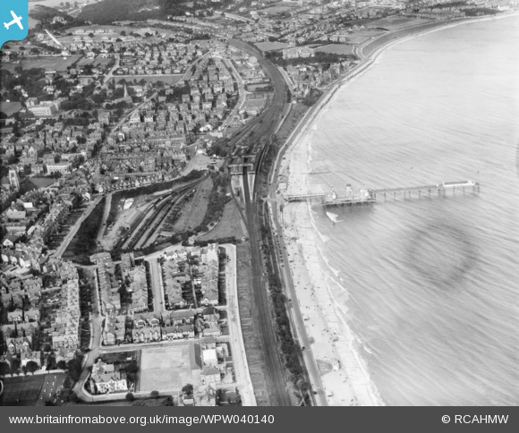
WPW040140 WALES (1932). General view of Colwyn Bay, oblique aerial view. 5"x4" black and white glass plate negative.
© Copyright OpenStreetMap contributors and licensed by the OpenStreetMap Foundation. 2026. Cartography is licensed as CC BY-SA.
Nearby Images (27)
Details
| Title | [WPW040140] General view of Colwyn Bay, oblique aerial view. 5"x4" black and white glass plate negative. |
| Reference | WPW040140 |
| Date | 1932 |
| Link | Coflein Archive Item 6369711 |
| Place name | |
| Parish | |
| District | |
| Country | WALES |
| Easting / Northing | 285000, 378000 |
| Longitude / Latitude | -3.7252641295253, 53.286201383428 |
| National Grid Reference | SH850780 |
Pins
Be the first to add a comment to this image!


![[WAW023343] View of Colwyn Bay showing pier](http://britainfromabove.org.uk/sites/all/libraries/aerofilms-images/public/100x100/WAW/023/WAW023343.jpg)
![[WAW023344] View of Colwyn Bay showing pier](http://britainfromabove.org.uk/sites/all/libraries/aerofilms-images/public/100x100/WAW/023/WAW023344.jpg)
![[WAW023345] View of Colwyn Bay showing station pier](http://britainfromabove.org.uk/sites/all/libraries/aerofilms-images/public/100x100/WAW/023/WAW023345.jpg)
![[WPW003057] View of Colwyn Bay showing railway station and residential area, oblique aerial view. 5"x4" black and white glass plate negative.](http://britainfromabove.org.uk/sites/all/libraries/aerofilms-images/public/100x100/WPW/003/WPW003057.jpg)
![[WPW003071] View of streets in Colwyn Bay, oblique aerial view. 5"x4" black and white glass plate negative.](http://britainfromabove.org.uk/sites/all/libraries/aerofilms-images/public/100x100/WPW/003/WPW003071.jpg)
![[WPW003072] View of Colwyn Bay showing Victoria pier and bathing huts, oblique aerial view. 5"x4" black and white glass plate negative.](http://britainfromabove.org.uk/sites/all/libraries/aerofilms-images/public/100x100/WPW/003/WPW003072.jpg)
![[WPW003074] View of Colwyn Bay showing pier, oblique aerial view. 5"x4" black and white glass plate negative.](http://britainfromabove.org.uk/sites/all/libraries/aerofilms-images/public/100x100/WPW/003/WPW003074.jpg)
![[WPW003075] General view of Colwyn Bay showing pier and Glan-y-Don, oblique aerial view. 5"x4" black and white glass plate negative.](http://britainfromabove.org.uk/sites/all/libraries/aerofilms-images/public/100x100/WPW/003/WPW003075.jpg)
![[WPW003076] View of Colwyn Bay showing part of town including St Paul's church, oblique aerial view. 5"x4" black and white glass plate negative.](http://britainfromabove.org.uk/sites/all/libraries/aerofilms-images/public/100x100/WPW/003/WPW003076.jpg)
![[WPW003078a] View of Colwyn Bay, oblique aerial view. 5"x4" black and white glass plate negative.](http://britainfromabove.org.uk/sites/all/libraries/aerofilms-images/public/100x100/WPW/003/WPW003078a.jpg)
![[WPW003079] View of Colwyn Bay showing pier, oblique aerial view. 5"x4" black and white glass plate negative.](http://britainfromabove.org.uk/sites/all/libraries/aerofilms-images/public/100x100/WPW/003/WPW003079.jpg)
![[WPW003082] View of Colwyn Bay centred on St Paul's church. Oblique aerial photograph, 5"x4" BW glass plate.](http://britainfromabove.org.uk/sites/all/libraries/aerofilms-images/public/100x100/WPW/003/WPW003082.jpg)
![[WPW040140] General view of Colwyn Bay, oblique aerial view. 5"x4" black and white glass plate negative.](http://britainfromabove.org.uk/sites/all/libraries/aerofilms-images/public/100x100/WPW/040/WPW040140.jpg)
![[WPW040141] General view of Colwyn Bay, oblique aerial view. 5"x4" black and white glass plate negative.](http://britainfromabove.org.uk/sites/all/libraries/aerofilms-images/public/100x100/WPW/040/WPW040141.jpg)
![[WPW040142] General view of Colwyn Bay, oblique aerial view. 5"x4" black and white glass plate negative.](http://britainfromabove.org.uk/sites/all/libraries/aerofilms-images/public/100x100/WPW/040/WPW040142.jpg)
![[WPW040143] General view of Colwyn Bay, oblique aerial view. 5"x4" black and white glass plate negative.](http://britainfromabove.org.uk/sites/all/libraries/aerofilms-images/public/100x100/WPW/040/WPW040143.jpg)
![[WPW045169] Distant view of Colwyn Bay, oblique aerial view. 5"x4" black and white glass plate negative.](http://britainfromabove.org.uk/sites/all/libraries/aerofilms-images/public/100x100/WPW/045/WPW045169.jpg)
![[WPW045170] Distant view of Colwyn Bay, oblique aerial view. 5"x4" black and white glass plate negative.](http://britainfromabove.org.uk/sites/all/libraries/aerofilms-images/public/100x100/WPW/045/WPW045170.jpg)
![[WPW045171] View of Colwyn Bay, oblique aerial view. 5"x4" black and white glass plate negative.](http://britainfromabove.org.uk/sites/all/libraries/aerofilms-images/public/100x100/WPW/045/WPW045171.jpg)
![[WPW045172] Distant view of Colwyn Bay. Oblique aerial photograph, 5"x4" BW glass plate.](http://britainfromabove.org.uk/sites/all/libraries/aerofilms-images/public/100x100/WPW/045/WPW045172.jpg)
![[WPW045173] View of Rhos-on-Sea showing swimming pool, pier, housing and pumping station, oblique aerial view. 5"x4" black and white glass plate negative.](http://britainfromabove.org.uk/sites/all/libraries/aerofilms-images/public/100x100/WPW/045/WPW045173.jpg)
![[WPW051604] View of Colwyn Bay showing pier and railway station, oblique aerial view. 5"x4" black and white glass plate negative.](http://britainfromabove.org.uk/sites/all/libraries/aerofilms-images/public/100x100/WPW/051/WPW051604.jpg)
![[WPW051605] View of Colwyn Bay showing Glan-y-Don and park, oblique aerial view. 5"x4" black and white glass plate negative.](http://britainfromabove.org.uk/sites/all/libraries/aerofilms-images/public/100x100/WPW/051/WPW051605.jpg)
![[WPW051606] View of Colwyn Bay showing pier, oblique aerial view. 5"x4" black and white glass plate negative.](http://britainfromabove.org.uk/sites/all/libraries/aerofilms-images/public/100x100/WPW/051/WPW051606.jpg)
![[WPW055744] General view of Colwyn Bay. Oblique aerial photograph, 5"x4" BW glass plate.](http://britainfromabove.org.uk/sites/all/libraries/aerofilms-images/public/100x100/WPW/055/WPW055744.jpg)
![[WPW055745] General view of Colwyn Bay, oblique aerial view. 5"x4" black and white glass plate negative.](http://britainfromabove.org.uk/sites/all/libraries/aerofilms-images/public/100x100/WPW/055/WPW055745.jpg)
![[WPW055746] General view of Colwyn Bay, oblique aerial view. 5"x4" black and white glass plate negative.](http://britainfromabove.org.uk/sites/all/libraries/aerofilms-images/public/100x100/WPW/055/WPW055746.jpg)