
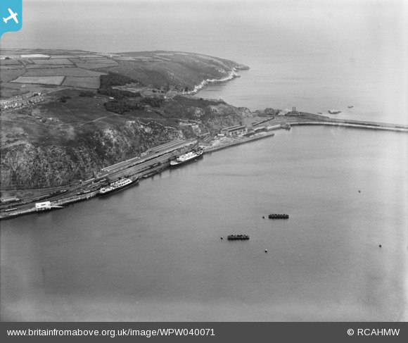
WPW040071 WALES (1932). View of Fishguard harbour, oblique aerial view. 5"x4" black and white glass plate negative.
© Copyright OpenStreetMap contributors and licensed by the OpenStreetMap Foundation. 2026. Cartography is licensed as CC BY-SA.
Nearby Images (6)
WPW029654

WPW029655

WPW029656

WPW029657

WPW029658

WPW040071

Details
| Title | [WPW040071] View of Fishguard harbour, oblique aerial view. 5"x4" black and white glass plate negative. |
| Reference | WPW040071 |
| Date | 1932 |
| Link | Coflein Archive Item 6369684 |
| Place name | |
| Parish | |
| District | |
| Country | WALES |
| Easting / Northing | 195140, 238750 |
| Longitude / Latitude | -4.985303134253, 52.008888390505 |
| National Grid Reference | SM951388 |
Pins

MB |
Friday 19th of October 2012 01:55:01 PM | |
|
MB |
Friday 19th of October 2012 01:54:33 PM | |
|
MB |
Friday 19th of October 2012 01:53:46 PM | |
|
MB |
Friday 19th of October 2012 01:53:26 PM | |
|
MB |
Friday 19th of October 2012 01:50:30 PM | |
|
MB |
Friday 19th of October 2012 01:49:57 PM | |
|
MB |
Friday 19th of October 2012 01:49:34 PM |
User Comment Contributions

A great view of a working port Fishguard Harbour. |
KimberlyBriscoe |
Monday 16th of December 2013 04:58:18 PM |
The Great Western Railway ran the ferry service at Fishgurard. It also ran the port of Rosslare in Ireland. Besides the Fishguard-Rosslare service, vessels also ran to Waterford and Cork from this port. One of the vessels seen here may have been the St Andrew of 2,702 tons, or its sister ship, the St David. Both were built for the Rosslare service by Cammell Laird in 1932. The St Andrew survived into British Railways service and was used on sailings until 1967. The St David was sunk in 1944. Cattle were shipped across the Irish Sea and Fishguard had cattle sheds to accommodate them. The sheds connected with the vessels' holds via two subways under the passenger station |
MB |
Friday 19th of October 2012 02:01:12 PM |