
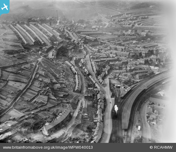
WPW040013 WALES (1932). General view of Pontypridd, oblique aerial view. 5"x4" black and white glass plate negative.
© Copyright OpenStreetMap contributors and licensed by the OpenStreetMap Foundation. 2026. Cartography is licensed as CC BY-SA.
Nearby Images (22)
WPW032420

WPW032421

WPW032422

WPW032490

WPW032491

WPW032492

WPW032493

WPW032494

WPW032495

WPW032496

WPW032518

WPW032525

WPW040013

WPW040014

WPW040015

WPW040016

WPW040017

WPW040018

WPW038318

WPW038319

WPW038320

WPW038321

Details
| Title | [WPW040013] General view of Pontypridd, oblique aerial view. 5"x4" black and white glass plate negative. |
| Reference | WPW040013 |
| Date | August-1932 |
| Link | Coflein Archive Item 6369629 |
| Place name | |
| Parish | |
| District | |
| Country | WALES |
| Easting / Northing | 307270, 189900 |
| Longitude / Latitude | -3.339005185903, 51.599827197382 |
| National Grid Reference | ST073899 |
Pins

IanGardiner |
Thursday 22nd of January 2026 11:06:16 PM | |
|
Chelsea61 |
Sunday 15th of October 2017 11:23:56 PM | |
|
gBr |
Thursday 4th of May 2017 04:57:21 PM | |
|
steve |
Thursday 14th of May 2015 06:06:33 PM | |
|
Alison Longman |
Thursday 19th of July 2012 07:48:12 AM | |
Sorry but this is not Wood Road, it's much further back down and cannot be seen on this photo. It is Rickards Street |
jamesy |
Monday 29th of December 2014 06:17:55 PM |
|
Alison Longman |
Thursday 19th of July 2012 07:45:25 AM | |
|
Alison Longman |
Thursday 19th of July 2012 07:40:43 AM | |
|
Alison Longman |
Thursday 19th of July 2012 07:39:49 AM | |
|
Chelsea61 |
Saturday 30th of June 2012 12:44:45 PM | |
|
Rob Daniels |
Friday 29th of June 2012 03:07:57 PM | |
|
Rob Daniels |
Friday 29th of June 2012 03:03:00 PM | |
|
Rob Daniels |
Friday 29th of June 2012 03:00:39 PM | |
|
Rob Daniels |
Friday 29th of June 2012 02:54:14 PM | |
|
Rob Daniels |
Friday 29th of June 2012 02:49:13 PM | |
|
Rob Daniels |
Friday 29th of June 2012 02:42:34 PM | |
Strictly speaking only part of the hospital car park occupies former station site. The station building stood on the opposite side of Albert Road, where the rather forbidding BT building is now. Albert Road bridge crossed the station half way along the platforms, a tiny fragment of one of the platform ramps may still be visible inside the tunnel portal, |
gerry-r |
Saturday 5th of July 2014 11:59:08 PM |
|
Rob Daniels |
Friday 29th of June 2012 02:30:41 PM | |
A bit misleading. A passenger train every 30 seconds ? With all the loaded coal trains moving down and empties up, plus passenger trains shuttling up and down there will have been frequent train movements, but if the average was every 30 secs that means that sometimes they were even more frequent than that. With manual signalling too. Those signalmen must have been a breed of supermen ! |
gBr |
Wednesday 10th of December 2014 06:18:26 PM |
|
Brian |
Tuesday 26th of June 2012 09:36:16 PM | |
|
Brian |
Tuesday 26th of June 2012 09:34:54 PM | |
|
Brian |
Tuesday 26th of June 2012 09:30:51 PM | |
This was knocked down to make way for Dewi Sant hospital |
Brian |
Tuesday 26th of June 2012 09:43:43 PM |
|
Brian |
Tuesday 26th of June 2012 09:20:44 PM |