
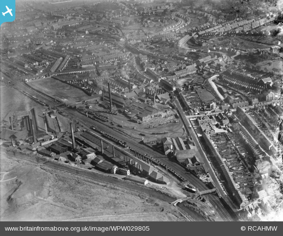
WPW029805 WALES (1929). View of Neath, oblique aerial view. 5"x4" black and white glass plate negative.
© Copyright OpenStreetMap contributors and licensed by the OpenStreetMap Foundation. 2026. Cartography is licensed as CC BY-SA.
Nearby Images (5)
WPW029799

WPW029802

WPW029804

WPW029805

WPW029807

Details
| Title | [WPW029805] View of Neath, oblique aerial view. 5"x4" black and white glass plate negative. |
| Reference | WPW029805 |
| Date | 1929 |
| Link | Coflein Archive Item 6370654 |
| Place name | |
| Parish | |
| District | |
| Country | WALES |
| Easting / Northing | 274000, 197000 |
| Longitude / Latitude | -3.8217466213702, 51.657179567368 |
| National Grid Reference | SS740970 |
Pins

Ifor |
Wednesday 10th of October 2018 05:47:04 PM | |
|
Ifor |
Wednesday 10th of October 2018 05:38:14 PM | |
|
Ifor |
Tuesday 15th of July 2014 02:35:12 PM | |
|
Ifor |
Tuesday 15th of July 2014 02:33:17 PM | |
|
Ifor |
Tuesday 15th of July 2014 02:31:42 PM | |
 |

Class31 |
Monday 28th of October 2013 02:11:41 PM |
|
Class31 |
Monday 28th of October 2013 02:05:04 PM | |
|
Class31 |
Monday 28th of October 2013 12:11:56 PM | |
|
sloyne |
Sunday 28th of July 2013 11:06:29 PM | |
|
an2nee |
Thursday 20th of September 2012 02:53:03 PM | |
This tag marks the Neath Steel Sheet and Galvanizing Works, the Galv, not the Japan. The Galv was approached by the long road running from the Royal Exchange on Briton Ferry Road on the town side of the Melin tinplate works to a footbridge and level crossing, situated adjacent to the entrance to the Galv. I walked or cycled down this road many, many times to visit my father at the Galv. |
Nisian |
Monday 27th of May 2013 11:36:57 AM |
|
an2nee |
Thursday 20th of September 2012 02:09:12 PM | |
No, this was the Eagle. |
Nisian |
Monday 27th of May 2013 11:40:49 AM |
|
an2nee |
Thursday 20th of September 2012 02:01:15 PM |


User Comment Contributions
clockwise from the 'Japan' works; GWR mainline,the Eagle(sbush) tinplate works,steel sheet Galvanizing works,just above there,alongside the canal was Melin Crythan Chemical works,then back across the gwr mainline,Melin Crythan tinplate works.across the main 'new'road from MC tinplate,was,melin crythan pond,between exchange rd & Bush Row.School rd runs at a right angle to the main rd,then Melin Crythan school and Mile End Row opposite the Japan works.there was also a tramway that went from the rail/canal bridge by the works,behind Mile End,then Between Walters & Evans' roads,across the middle of school road & up to Eaglesbush Iron Foundry & colliery,across Old(turnpike) road..from o/s 1946,25"/mile map |
greg |
Saturday 19th of April 2014 11:22:55 AM |

Crown Foods UK Plant known locally as the Metal Box. Photo taken 25/10/2013. |
Class31 |
Monday 28th of October 2013 02:15:14 PM |
View north east from the railway footbridge on 25/10/2013 |
Class31 |
Monday 28th of October 2013 02:08:02 PM |
The tags are not correct. The works tagged as the Japan was the Neath Steel Sheet and Galvanizing Works, the Galv, and the works tagged as the Galv was in fact the Eaglesbush Tinplate Works, known as the Eagle. The Galv was approached by the long road running from the Royal Exchange on Briton Ferry Road on the town side of the Melin tinplate works to a footbridge and level crossing, situated adjacent to the entrance to the Galv. I walked or cycled down this road many, many times to visit my father at the Galv. remove | report abuse |
Nisian |
Monday 27th of May 2013 11:39:57 AM |
This image clearly shows how heavily industrialised Neath was in the early 1900's. There were many Tin Works in the Neath area at this time and they created thousands of jobs for the local men. Many women werea also employed in the various heavy industries at this time. |
an2nee |
Thursday 20th of September 2012 02:38:37 PM |