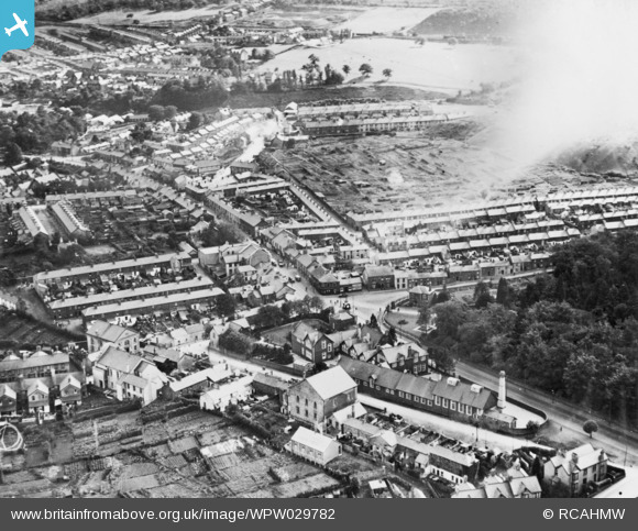
WPW029782 WALES (1929). General view of Aberdare. Oblique aerial photograph.
© Copyright OpenStreetMap contributors and licensed by the OpenStreetMap Foundation. 2026. Cartography is licensed as CC BY-SA.
Nearby Images (22)
Details
| Title | [WPW029782] General view of Aberdare. Oblique aerial photograph. |
| Reference | WPW029782 |
| Date | 1929 |
| Link | Coflein Archive Item 6423216 |
| Place name | |
| Parish | |
| District | |
| Country | WALES |
| Easting / Northing | 300180, 202590 |
| Longitude / Latitude | -3.444973806744, 51.712690668878 |
| National Grid Reference | SO002026 |
Pins

Justpassingthru |
Friday 1st of September 2023 11:23:57 AM | |

Justpassingthru |
Friday 1st of September 2023 11:21:17 AM | |

CR |
Wednesday 1st of August 2018 12:02:19 PM | |

CR |
Wednesday 1st of August 2018 12:01:45 PM | |

CR |
Wednesday 1st of August 2018 12:01:21 PM | |

CR |
Wednesday 1st of August 2018 12:00:46 PM |


![[WPW029708] View of part of Aberdare showing St Elvan's church and Gadlys school. Oblique aerial photograph, 5"x4" BW glass plate.](http://britainfromabove.org.uk/sites/all/libraries/aerofilms-images/public/100x100/WPW/029/WPW029708.jpg)
![[WPW029768] General view of Aberdare. Oblique aerial photograph, 5"x4" BW glass plate.](http://britainfromabove.org.uk/sites/all/libraries/aerofilms-images/public/100x100/WPW/029/WPW029768.jpg)
![[WPW029769] General view of Aberdare. Oblique aerial photograph, 5"x4" BW glass plate.](http://britainfromabove.org.uk/sites/all/libraries/aerofilms-images/public/100x100/WPW/029/WPW029769.jpg)
![[WPW029773] View of Aberdare, oblique aerial view. 5"x4" black and white glass plate negative.](http://britainfromabove.org.uk/sites/all/libraries/aerofilms-images/public/100x100/WPW/029/WPW029773.jpg)
![[WPW029781] General view of Aberdare. Oblique aerial photograph, 5"x4" BW glass plate.](http://britainfromabove.org.uk/sites/all/libraries/aerofilms-images/public/100x100/WPW/029/WPW029781.jpg)
![[WPW029782] General view of Aberdare. Oblique aerial photograph.](http://britainfromabove.org.uk/sites/all/libraries/aerofilms-images/public/100x100/WPW/029/WPW029782.jpg)
![[WPW029784] View of Aberdare showing St Elvan's church. Oblique aerial photograph, 5"x4" BW glass plate.](http://britainfromabove.org.uk/sites/all/libraries/aerofilms-images/public/100x100/WPW/029/WPW029784.jpg)
![[WPW029786] View of Aberdare showing theatre. Oblique aerial photograph, 5"x4" BW glass plate.](http://britainfromabove.org.uk/sites/all/libraries/aerofilms-images/public/100x100/WPW/029/WPW029786.jpg)
![[WPW029787] View of Aberdare showing St Mary's church. Oblique aerial photograph, 5"x4" BW glass plate.](http://britainfromabove.org.uk/sites/all/libraries/aerofilms-images/public/100x100/WPW/029/WPW029787.jpg)
![[WPW029812] Distant view of Aberdare, oblique aerial view. 5"x4" black and white glass plate negative.](http://britainfromabove.org.uk/sites/all/libraries/aerofilms-images/public/100x100/WPW/029/WPW029812.jpg)
![[WPW029813] View of Aberdare, oblique aerial view. 5"x4" black and white glass plate negative.](http://britainfromabove.org.uk/sites/all/libraries/aerofilms-images/public/100x100/WPW/029/WPW029813.jpg)
![[WPW032559] General view of Aberdare, oblique aerial view. 5"x4" black and white glass plate negative.](http://britainfromabove.org.uk/sites/all/libraries/aerofilms-images/public/100x100/WPW/032/WPW032559.jpg)
![[WPW032560] General view of Aberdare, oblique aerial view. 5"x4" black and white glass plate negative.](http://britainfromabove.org.uk/sites/all/libraries/aerofilms-images/public/100x100/WPW/032/WPW032560.jpg)
![[WPW032561] General view of Aberdare, oblique aerial view. 5"x4" black and white glass plate negative.](http://britainfromabove.org.uk/sites/all/libraries/aerofilms-images/public/100x100/WPW/032/WPW032561.jpg)
![[WPW032562] General view of Aberdare, showing park, oblique aerial view. 5"x4" black and white glass plate negative.](http://britainfromabove.org.uk/sites/all/libraries/aerofilms-images/public/100x100/WPW/032/WPW032562.jpg)
![[WPW032563] General view of Aberdare, showing park, oblique aerial view. 5"x4" black and white glass plate negative.](http://britainfromabove.org.uk/sites/all/libraries/aerofilms-images/public/100x100/WPW/032/WPW032563.jpg)
![[WPW039993] General view of Aberdare, oblique aerial view. 5"x4" black and white glass plate negative.](http://britainfromabove.org.uk/sites/all/libraries/aerofilms-images/public/100x100/WPW/039/WPW039993.jpg)
![[WPW039994] General view of Aberdare, oblique aerial view. 5"x4" black and white glass plate negative.](http://britainfromabove.org.uk/sites/all/libraries/aerofilms-images/public/100x100/WPW/039/WPW039994.jpg)
![[WPW039995] General view of Aberdare, oblique aerial view. 5"x4" black and white glass plate negative.](http://britainfromabove.org.uk/sites/all/libraries/aerofilms-images/public/100x100/WPW/039/WPW039995.jpg)
![[WPW039996] General view of Aberdare, oblique aerial view. 5"x4" black and white glass plate negative.](http://britainfromabove.org.uk/sites/all/libraries/aerofilms-images/public/100x100/WPW/039/WPW039996.jpg)
![[WPW054901] View of Aberdare showing distant view of Ynys Stadium, oblique aerial view. 5"x4" black and white glass plate negative.](http://britainfromabove.org.uk/sites/all/libraries/aerofilms-images/public/100x100/WPW/054/WPW054901.jpg)
![[WPW029779] View of St Elvan's church, Aberdare, oblique aerial view. 5"x4" black and white glass plate negative.](http://britainfromabove.org.uk/sites/all/libraries/aerofilms-images/public/100x100/WPW/029/WPW029779.jpg)