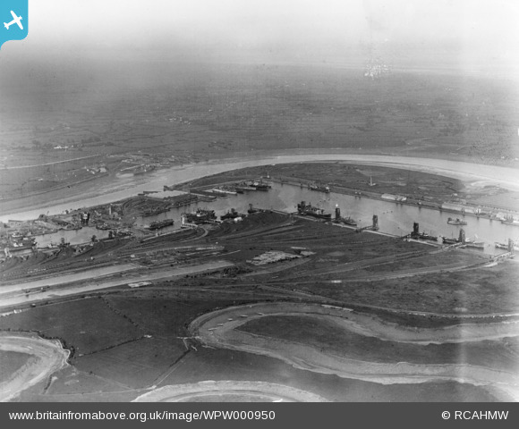
WPW000950 WALES (1920). View of Newport Docks, oblique aerial view. 5"x4" black and white glass plate negative.
© Copyright OpenStreetMap contributors and licensed by the OpenStreetMap Foundation. 2026. Cartography is licensed as CC BY-SA.
Nearby Images (48)
Details
| Title | [WPW000950] View of Newport Docks, oblique aerial view. 5"x4" black and white glass plate negative. |
| Reference | WPW000950 |
| Date | May-1920 |
| Link | Coflein Archive Item 6370200 |
| Place name | |
| Parish | |
| District | |
| Country | WALES |
| Easting / Northing | 332000, 185000 |
| Longitude / Latitude | -2.9810258050216, 51.559300746076 |
| National Grid Reference | ST320850 |
Pins
Be the first to add a comment to this image!
User Comment Contributions

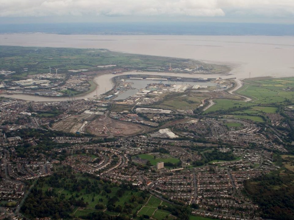
A fantastic aerial view of Newport Docks taken 9th October 2013 courtesy Mr. Conway Shields. We can compare the changes over the years. We can see the iconic Grade 1 listed Newport Transporter Bridge in the recent photo. |

Class31 |
Sunday 3rd of November 2013 03:12:23 PM |


![[WAW005369] View of Newport Docks](http://britainfromabove.org.uk/sites/all/libraries/aerofilms-images/public/100x100/WAW/005/WAW005369.jpg)
![[WAW005370] View of Newport Docks](http://britainfromabove.org.uk/sites/all/libraries/aerofilms-images/public/100x100/WAW/005/WAW005370.jpg)
![[WAW005371] View of Newport Docks](http://britainfromabove.org.uk/sites/all/libraries/aerofilms-images/public/100x100/WAW/005/WAW005371.jpg)
![[WAW005372] View of Newport Docks](http://britainfromabove.org.uk/sites/all/libraries/aerofilms-images/public/100x100/WAW/005/WAW005372.jpg)
![[WAW005373] View of Newport Docks](http://britainfromabove.org.uk/sites/all/libraries/aerofilms-images/public/100x100/WAW/005/WAW005373.jpg)
![[WAW005374] View of Newport Docks showing central store depot buildings](http://britainfromabove.org.uk/sites/all/libraries/aerofilms-images/public/100x100/WAW/005/WAW005374.jpg)
![[WAW005375] View of Newport Docks](http://britainfromabove.org.uk/sites/all/libraries/aerofilms-images/public/100x100/WAW/005/WAW005375.jpg)
![[WAW005376] View of Newport Docks](http://britainfromabove.org.uk/sites/all/libraries/aerofilms-images/public/100x100/WAW/005/WAW005376.jpg)
![[WAW005377] View of Newport Docks showing central store depot buildings](http://britainfromabove.org.uk/sites/all/libraries/aerofilms-images/public/100x100/WAW/005/WAW005377.jpg)
![[WAW005378] View of Newport Docks](http://britainfromabove.org.uk/sites/all/libraries/aerofilms-images/public/100x100/WAW/005/WAW005378.jpg)
![[WAW005379] View of Newport Docks](http://britainfromabove.org.uk/sites/all/libraries/aerofilms-images/public/100x100/WAW/005/WAW005379.jpg)
![[WAW010872] General view of newport docks](http://britainfromabove.org.uk/sites/all/libraries/aerofilms-images/public/100x100/WAW/010/WAW010872.jpg)
![[WAW010873] General view of newport docks](http://britainfromabove.org.uk/sites/all/libraries/aerofilms-images/public/100x100/WAW/010/WAW010873.jpg)
![[WAW010874] General view of newport docks](http://britainfromabove.org.uk/sites/all/libraries/aerofilms-images/public/100x100/WAW/010/WAW010874.jpg)
![[WAW010875] General view of newport docks](http://britainfromabove.org.uk/sites/all/libraries/aerofilms-images/public/100x100/WAW/010/WAW010875.jpg)
![[WAW010876] General view of newport docks](http://britainfromabove.org.uk/sites/all/libraries/aerofilms-images/public/100x100/WAW/010/WAW010876.jpg)
![[WAW010877] General view of newport docks](http://britainfromabove.org.uk/sites/all/libraries/aerofilms-images/public/100x100/WAW/010/WAW010877.jpg)
![[WAW010878] General view of newport docks](http://britainfromabove.org.uk/sites/all/libraries/aerofilms-images/public/100x100/WAW/010/WAW010878.jpg)
![[WAW010879] General view of newport docks](http://britainfromabove.org.uk/sites/all/libraries/aerofilms-images/public/100x100/WAW/010/WAW010879.jpg)
![[WAW010880] General view of newport docks](http://britainfromabove.org.uk/sites/all/libraries/aerofilms-images/public/100x100/WAW/010/WAW010880.jpg)
![[WAW010881] General view of newport docks](http://britainfromabove.org.uk/sites/all/libraries/aerofilms-images/public/100x100/WAW/010/WAW010881.jpg)
![[WAW010882] General view of newport docks](http://britainfromabove.org.uk/sites/all/libraries/aerofilms-images/public/100x100/WAW/010/WAW010882.jpg)
![[WAW010883] General view of newport docks](http://britainfromabove.org.uk/sites/all/libraries/aerofilms-images/public/100x100/WAW/010/WAW010883.jpg)
![[WAW010885] General view of newport docks](http://britainfromabove.org.uk/sites/all/libraries/aerofilms-images/public/100x100/WAW/010/WAW010885.jpg)
![[WAW010886] General view of newport docks](http://britainfromabove.org.uk/sites/all/libraries/aerofilms-images/public/100x100/WAW/010/WAW010886.jpg)
![[WAW010888] General view of newport docks](http://britainfromabove.org.uk/sites/all/libraries/aerofilms-images/public/100x100/WAW/010/WAW010888.jpg)
![[WAW010889] General view of newport docks](http://britainfromabove.org.uk/sites/all/libraries/aerofilms-images/public/100x100/WAW/010/WAW010889.jpg)
![[WAW010890] General view of newport docks](http://britainfromabove.org.uk/sites/all/libraries/aerofilms-images/public/100x100/WAW/010/WAW010890.jpg)
![[WAW010891] General view of newport docks](http://britainfromabove.org.uk/sites/all/libraries/aerofilms-images/public/100x100/WAW/010/WAW010891.jpg)
![[WAW010893] General view of newport docks](http://britainfromabove.org.uk/sites/all/libraries/aerofilms-images/public/100x100/WAW/010/WAW010893.jpg)
![[WAW010894] General view of newport docks](http://britainfromabove.org.uk/sites/all/libraries/aerofilms-images/public/100x100/WAW/010/WAW010894.jpg)
![[WAW011860] View of Newport Docks](http://britainfromabove.org.uk/sites/all/libraries/aerofilms-images/public/100x100/WAW/011/WAW011860.jpg)
![[WAW011861] View of Newport Docks](http://britainfromabove.org.uk/sites/all/libraries/aerofilms-images/public/100x100/WAW/011/WAW011861.jpg)
![[WAW011862] View of Newport Docks](http://britainfromabove.org.uk/sites/all/libraries/aerofilms-images/public/100x100/WAW/011/WAW011862.jpg)
![[WAW011863] View of Newport Docks](http://britainfromabove.org.uk/sites/all/libraries/aerofilms-images/public/100x100/WAW/011/WAW011863.jpg)
![[WAW011864] View of Newport Docks](http://britainfromabove.org.uk/sites/all/libraries/aerofilms-images/public/100x100/WAW/011/WAW011864.jpg)
![[WPW000950] View of Newport Docks, oblique aerial view. 5"x4" black and white glass plate negative.](http://britainfromabove.org.uk/sites/all/libraries/aerofilms-images/public/100x100/WPW/000/WPW000950.jpg)
![[WPW016929] View of Newport Docks, oblique aerial view. 5"x4" black and white glass plate negative.](http://britainfromabove.org.uk/sites/all/libraries/aerofilms-images/public/100x100/WPW/016/WPW016929.jpg)
![[WPW016930] View of Newport Docks, oblique aerial view. 5"x4" black and white glass plate negative.](http://britainfromabove.org.uk/sites/all/libraries/aerofilms-images/public/100x100/WPW/016/WPW016930.jpg)
![[WPW016931] View of Newport Docks, oblique aerial view. 5"x4" black and white glass plate negative.](http://britainfromabove.org.uk/sites/all/libraries/aerofilms-images/public/100x100/WPW/016/WPW016931.jpg)
![[WPW016932] View of Newport Docks, oblique aerial view. 5"x4" black and white glass plate negative.](http://britainfromabove.org.uk/sites/all/libraries/aerofilms-images/public/100x100/WPW/016/WPW016932.jpg)
![[WPW022283] View of Newport docks, oblique aerial view. 5"x4" black and white glass plate negative.](http://britainfromabove.org.uk/sites/all/libraries/aerofilms-images/public/100x100/WPW/022/WPW022283.jpg)
![[WPW029311] View of Newport Docks, oblique aerial view. 5"x4" black and white glass plate negative.](http://britainfromabove.org.uk/sites/all/libraries/aerofilms-images/public/100x100/WPW/029/WPW029311.jpg)
![[WPW029312] View of Newport Docks, oblique aerial view. 5"x4" black and white glass plate negative.](http://britainfromabove.org.uk/sites/all/libraries/aerofilms-images/public/100x100/WPW/029/WPW029312.jpg)
![[WPW032464] General view of Newport Dock, oblique aerial view. 5"x4" black and white glass plate negative.](http://britainfromabove.org.uk/sites/all/libraries/aerofilms-images/public/100x100/WPW/032/WPW032464.jpg)
![[WPW037153] View of Newport Docks, oblique aerial view. 5"x4" black and white glass plate negative.](http://britainfromabove.org.uk/sites/all/libraries/aerofilms-images/public/100x100/WPW/037/WPW037153.jpg)
![[WPW051697] View of Newport Docks and Whitehead Iron & Steel Co., Newport, oblique aerial view. 5"x4" black and white glass plate negative.](http://britainfromabove.org.uk/sites/all/libraries/aerofilms-images/public/100x100/WPW/051/WPW051697.jpg)
![[WPW051698] View of Newport Docks and Whitehead Iron & Steel Co., Newport, oblique aerial view. 5"x4" black and white glass plate negative.](http://britainfromabove.org.uk/sites/all/libraries/aerofilms-images/public/100x100/WPW/051/WPW051698.jpg)