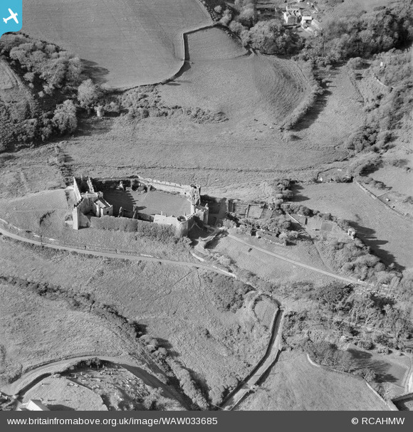
WAW033685 WALES (1950). View of Manorbier castle

© Copyright OpenStreetMap contributors and licensed by the OpenStreetMap Foundation. 2026. Cartography is licensed as CC BY-SA.

Nearby Images (6)

WAW005917
  0° 0m
WAW005918
  0° 0m
WAW005919
  0° 0m
WAW005922
  0° 0m
WAW033685
  0° 0m
WAW033686
  0° 0m

Details

Title [WAW033685] View of Manorbier castle
Reference WAW033685
Date 1950
Link Coflein Archive Item 6414389
Place name
Parish
District
Country WALES
Easting / Northing 206390, 197790
Longitude / Latitude -4.7986731193922, 51.645057592968
National Grid Reference SS064978

Pins

Remains of tower in wall of outer ward.

Adrian James
Wednesday 23rd of November 2016 01:09:03 PM
Cemetary of St James Church, Manorbier

totoro
Thursday 7th of August 2014 08:08:09 PM
Site of 19th C tennis court

totoro
Thursday 7th of August 2014 07:54:04 PM
Manorbier Castle. Postcode: SA70 7SY Scheduled monument: Ancient Monument No.Pe004 and grade 1 listed building: Cadw Building ID: 5976 Privately owned. The castle is generally open to the public for a fee when there are no weddings or other events taking place. The more modern house and chalet annex may be booked for self catering holidays (entry to castle is then included and includes sole use of the inner lawns after closing time). Bus 349 from Tenby stops nearby. In 1146 Gerald of Wales, the great twelfth century scholar known as Geraldus Cambrensis was born at the castle. As the fourth son of William de Barri, he was related on his mothers's side, to the legendary Welsh princess Nest verch Rhys. Gerald wrote of his birthplace: In all the broad lands of Wales, Manorbier is the most pleasant place by far. In 1670 the Crown sold the castle to Sir Erasmus Philipps of Picton, and ownership remains with his descendents. Through the 17th and 18th centuries Manorbier was allowed to decay. However in 1880, the castle was partially restored by J.R.Cobb, a tenant who carried out repairs on the buildings and walls. J R Cobb also levelled a part of the inner court for a tennis court. At the SW is the mediaeval house, consisting of a hall and 2 later wings. The hall is about 10.5 m by 6.6 m, with a large lateral fireplace on the NE side, with big corbels for the hood. To the NW of the Hall is a Buttery and above that a Solar. The Chapel was added c.1260. It is aligned to true E, without regard to adjacent structures. It is almost as large as the Hall, and much ornamented. To the NE of the Inner Ward is the entrance with gate-towers and 2 large corner towers. The ruinous Old Tower to the NW of the present entrance is probably contemporary with the Hall. The curtain wall and the corner towers are probably c.1230. The most complete feature is the Round Tower, with 4 storeys (the floors restored) and battlements. The windows and door recesses are in deep arch-headed alcoves, as the wall is about 1.5 m thick. The 2003 film I Capture the Castle was shot largely on location at the castle. see Wikipedia [[Manorbier Castle]] image is copyright ainslie and used under Creative Commons Attribution Share Alike license. Image source [[File:Entrance DSC 6946.jpg]] Photo taken September 2012 See also http://manorbiercastle.co.uk

totoro
Thursday 7th of August 2014 07:52:09 PM
Hearth and oven

totoro
Thursday 7th of August 2014 07:09:11 PM
Sub chapel c 1260 Weddings can be held here

totoro
Thursday 7th of August 2014 07:06:25 PM
Hall Block 12th C

totoro
Thursday 7th of August 2014 07:05:17 PM
Gatehouse 13th Cent

totoro
Thursday 7th of August 2014 07:03:32 PM
North Tower c1230

totoro
Thursday 7th of August 2014 07:00:05 PM
Round Tower c 1230

totoro
Thursday 7th of August 2014 06:59:08 PM