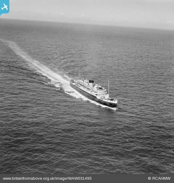
WAW031495 WALES (1950). View of the ship "Hibernia" en-route to Holyhead
© Copyright OpenStreetMap contributors and licensed by the OpenStreetMap Foundation. 2026. Cartography is licensed as CC BY-SA.
Nearby Images (19)
Details
| Title | [WAW031495] View of the ship "Hibernia" en-route to Holyhead |
| Reference | WAW031495 |
| Date | 1950 |
| Link | Coflein Archive Item 6414288 |
| Place name | |
| Parish | |
| District | |
| Country | WALES |
| Easting / Northing | 224708, 382127 |
| Longitude / Latitude | -4.6311964025133, 53.306758766532 |
| National Grid Reference | SH247821 |
Pins

mannidaze |
Saturday 20th of September 2014 04:47:13 PM |


![[WAW031483] Distant view of Holyhead](http://britainfromabove.org.uk/sites/all/libraries/aerofilms-images/public/100x100/WAW/031/WAW031483.jpg)
![[WAW031484] Distant view of Holyhead](http://britainfromabove.org.uk/sites/all/libraries/aerofilms-images/public/100x100/WAW/031/WAW031484.jpg)
![[WAW031485] View of Holyhead showing port](http://britainfromabove.org.uk/sites/all/libraries/aerofilms-images/public/100x100/WAW/031/WAW031485.jpg)
![[WAW031486] View of Holyhead showing port, and nissen huts on Turkey shore (foreground)](http://britainfromabove.org.uk/sites/all/libraries/aerofilms-images/public/100x100/WAW/031/WAW031486.jpg)
![[WAW031487] View of Holyhead showing port](http://britainfromabove.org.uk/sites/all/libraries/aerofilms-images/public/100x100/WAW/031/WAW031487.jpg)
![[WAW031495] View of the ship "Hibernia" en-route to Holyhead](http://britainfromabove.org.uk/sites/all/libraries/aerofilms-images/public/100x100/WAW/031/WAW031495.jpg)
![[WAW031496] View of the ship "Hibernia" en-route to Holyhead](http://britainfromabove.org.uk/sites/all/libraries/aerofilms-images/public/100x100/WAW/031/WAW031496.jpg)
![[WAW049712] View of Holyhead showing Le Bon Sauveur convent](http://britainfromabove.org.uk/sites/all/libraries/aerofilms-images/public/100x100/WAW/049/WAW049712.jpg)
![[WAW049713] View of Holyhead showing Le Bon Sauveur convent](http://britainfromabove.org.uk/sites/all/libraries/aerofilms-images/public/100x100/WAW/049/WAW049713.jpg)
![[WAW049714] View of Holyhead showing Le Bon Sauveur convent](http://britainfromabove.org.uk/sites/all/libraries/aerofilms-images/public/100x100/WAW/049/WAW049714.jpg)
![[WAW049715] View of Holyhead showing Le Bon Sauveur convent](http://britainfromabove.org.uk/sites/all/libraries/aerofilms-images/public/100x100/WAW/049/WAW049715.jpg)
![[WAW049716] View of Holyhead showing Le Bon Sauveur convent](http://britainfromabove.org.uk/sites/all/libraries/aerofilms-images/public/100x100/WAW/049/WAW049716.jpg)
![[WAW049717] View of Holyhead showing Le Bon Sauveur convent](http://britainfromabove.org.uk/sites/all/libraries/aerofilms-images/public/100x100/WAW/049/WAW049717.jpg)
![[WPW009484] View of Holyhead showing harbour. Oblique aerial photograph, 5"x4" BW glass plate.](http://britainfromabove.org.uk/sites/all/libraries/aerofilms-images/public/100x100/WPW/009/WPW009484.jpg)
![[WPW009485] View of Holyhead showing the Bon Sauveur convent. Oblique aerial photograph, 5"x4" BW glass plate.](http://britainfromabove.org.uk/sites/all/libraries/aerofilms-images/public/100x100/WPW/009/WPW009485.jpg)
![[WPW009486] View of Holyhead showing the Bon Sauveur convent. Oblique aerial photograph, 5"x4" BW glass plate.](http://britainfromabove.org.uk/sites/all/libraries/aerofilms-images/public/100x100/WPW/009/WPW009486.jpg)
![[WPW009487] View of Holyhead showing docks, oblique aerial view. 5"x4" black and white glass plate negative.](http://britainfromabove.org.uk/sites/all/libraries/aerofilms-images/public/100x100/WPW/009/WPW009487.jpg)
![[WPW009488] View of Holyhead showing docks, oblique aerial view. 5"x4" black and white glass plate negative.](http://britainfromabove.org.uk/sites/all/libraries/aerofilms-images/public/100x100/WPW/009/WPW009488.jpg)
![[WPW009490] View of Holyhead showing football ground and docks, oblique aerial view. 5"x4" black and white glass plate negative.](http://britainfromabove.org.uk/sites/all/libraries/aerofilms-images/public/100x100/WPW/009/WPW009490.jpg)