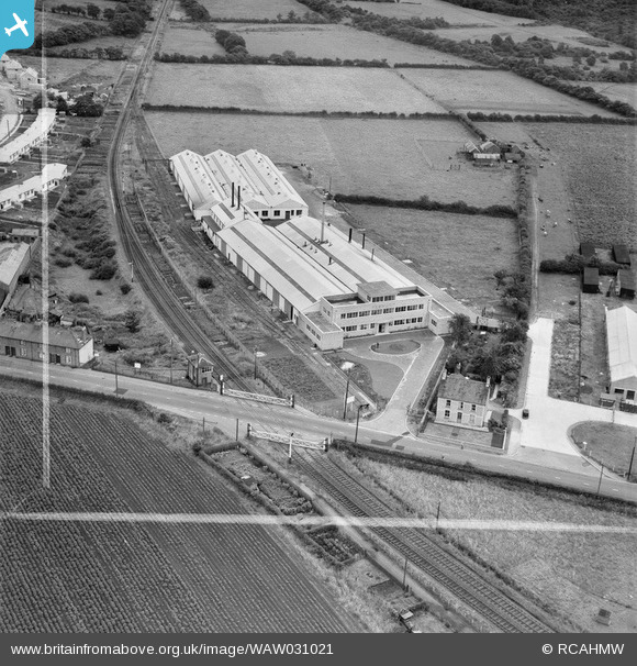
WAW031021 WALES (1950). View of factories and housing near Talbot Green, including temporary prefab housing
© Copyright OpenStreetMap contributors and licensed by the OpenStreetMap Foundation. 2026. Cartography is licensed as CC BY-SA.
Nearby Images (9)
Details
| Title | [WAW031021] View of factories and housing near Talbot Green, including temporary prefab housing |
| Reference | WAW031021 |
| Date | 1950 |
| Link | Coflein Archive Item 6414254 |
| Place name | |
| Parish | |
| District | |
| Country | WALES |
| Easting / Northing | 303767, 182424 |
| Longitude / Latitude | -3.387524636279, 51.532031969535 |
| National Grid Reference | ST038824 |
Pins

MB |
Sunday 18th of May 2014 08:08:42 AM |


![[WAW031021] View of factories and housing near Talbot Green, including temporary prefab housing](http://britainfromabove.org.uk/sites/all/libraries/aerofilms-images/public/100x100/WAW/031/WAW031021.jpg)
![[WAW031022] View of factories and housing near Talbot Green, including temporary prefab housing](http://britainfromabove.org.uk/sites/all/libraries/aerofilms-images/public/100x100/WAW/031/WAW031022.jpg)
![[WAW031023] View of factories and housing near Talbot Green, including temporary prefab housing](http://britainfromabove.org.uk/sites/all/libraries/aerofilms-images/public/100x100/WAW/031/WAW031023.jpg)
![[WAW031024] View of factories and housing near Talbot Green, including temporary prefab housing](http://britainfromabove.org.uk/sites/all/libraries/aerofilms-images/public/100x100/WAW/031/WAW031024.jpg)
![[WAW031025] View of factories and housing near Talbot Green, including temporary prefab housing](http://britainfromabove.org.uk/sites/all/libraries/aerofilms-images/public/100x100/WAW/031/WAW031025.jpg)
![[WAW031026] View of factories and housing near Talbot Green, including temporary prefab housing](http://britainfromabove.org.uk/sites/all/libraries/aerofilms-images/public/100x100/WAW/031/WAW031026.jpg)
![[WAW031027] View of factories and housing near Talbot Green, including temporary prefab housing](http://britainfromabove.org.uk/sites/all/libraries/aerofilms-images/public/100x100/WAW/031/WAW031027.jpg)
![[WAW031028] View of factories and housing near Talbot Green, including temporary prefab housing](http://britainfromabove.org.uk/sites/all/libraries/aerofilms-images/public/100x100/WAW/031/WAW031028.jpg)
![[WAW031029] View of factories and housing near Talbot Green, including temporary prefab housing](http://britainfromabove.org.uk/sites/all/libraries/aerofilms-images/public/100x100/WAW/031/WAW031029.jpg)