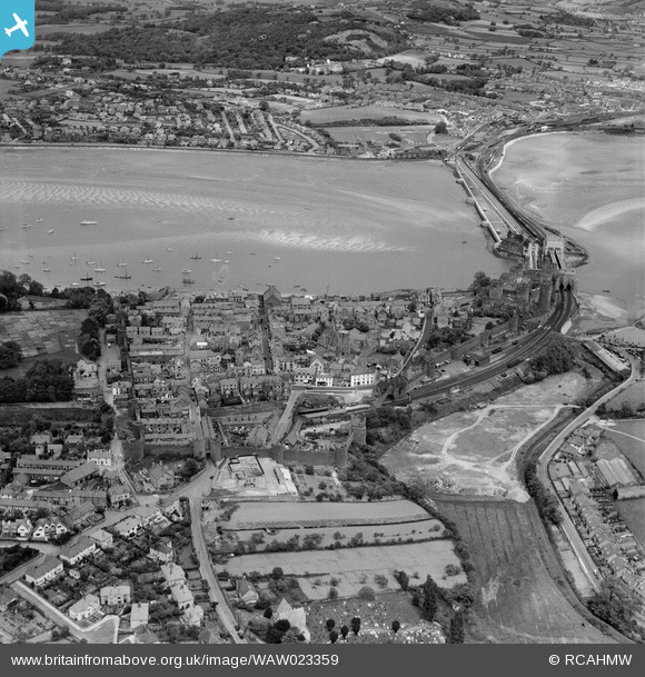
WAW023359 WALES (1949). General view of Conwy showing bridges and Llandudno Junction in distance
© Copyright OpenStreetMap contributors and licensed by the OpenStreetMap Foundation. 2026. Cartography is licensed as CC BY-SA.
Nearby Images (33)
Details
| Title | [WAW023359] General view of Conwy showing bridges and Llandudno Junction in distance |
| Reference | WAW023359 |
| Date | 1949 |
| Link | Coflein Archive Item 6414031 |
| Place name | |
| Parish | |
| District | |
| Country | WALES |
| Easting / Northing | 278055, 377527 |
| Longitude / Latitude | -3.8292169972257, 53.280399107294 |
| National Grid Reference | SH781775 |
Pins

gBr |
Wednesday 3rd of May 2017 10:21:45 PM | |

Mr Gwyn Hughes |
Sunday 12th of February 2017 11:09:05 PM | |

Alan McFaden |
Monday 1st of September 2014 09:48:15 AM | |

Alan McFaden |
Monday 1st of September 2014 09:47:44 AM | |

Alan McFaden |
Monday 1st of September 2014 09:47:04 AM | |

Alan McFaden |
Monday 1st of September 2014 09:46:31 AM |
User Comment Contributions

Conwy Castle Town Wall |

Alan McFaden |
Monday 1st of September 2014 09:49:02 AM |

Conwy Castle |

Alan McFaden |
Monday 1st of September 2014 09:48:38 AM |


![[WAW001726] View of Conwy showing castle](http://britainfromabove.org.uk/sites/all/libraries/aerofilms-images/public/100x100/WAW/001/WAW001726.jpg)
![[WAW001727] View of Conwy showing castle](http://britainfromabove.org.uk/sites/all/libraries/aerofilms-images/public/100x100/WAW/001/WAW001727.jpg)
![[WAW001728] View of Conwy showing castle](http://britainfromabove.org.uk/sites/all/libraries/aerofilms-images/public/100x100/WAW/001/WAW001728.jpg)
![[WAW001736] View of Conwy showing town walls](http://britainfromabove.org.uk/sites/all/libraries/aerofilms-images/public/100x100/WAW/001/WAW001736.jpg)
![[WAW023353] View of Conwy showing castle and bridges](http://britainfromabove.org.uk/sites/all/libraries/aerofilms-images/public/100x100/WAW/023/WAW023353.jpg)
![[WAW023354] View of Conwy showing castle and bridges](http://britainfromabove.org.uk/sites/all/libraries/aerofilms-images/public/100x100/WAW/023/WAW023354.jpg)
![[WAW023355] View of Conwy showing castle, bridges and mussel purification station](http://britainfromabove.org.uk/sites/all/libraries/aerofilms-images/public/100x100/WAW/023/WAW023355.jpg)
![[WAW023356] View of Conwy showing castle, bridges and mussel purification station](http://britainfromabove.org.uk/sites/all/libraries/aerofilms-images/public/100x100/WAW/023/WAW023356.jpg)
![[WAW023357] General view of Conwy](http://britainfromabove.org.uk/sites/all/libraries/aerofilms-images/public/100x100/WAW/023/WAW023357.jpg)
![[WAW023358] View of Conwy showing castle, bridges and mussel purification station](http://britainfromabove.org.uk/sites/all/libraries/aerofilms-images/public/100x100/WAW/023/WAW023358.jpg)
![[WAW023359] General view of Conwy showing bridges and Llandudno Junction in distance](http://britainfromabove.org.uk/sites/all/libraries/aerofilms-images/public/100x100/WAW/023/WAW023359.jpg)
![[WAW023360] General view of Conwy showing Blodlondeb woods and mansion](http://britainfromabove.org.uk/sites/all/libraries/aerofilms-images/public/100x100/WAW/023/WAW023360.jpg)
![[WPW002047A] View of Conwy Castle showing railway bridge, oblique aerial view. 5"x4" black and white glass plate negative.](http://britainfromabove.org.uk/sites/all/libraries/aerofilms-images/public/100x100/WPW/002/WPW002047A.jpg)
![[WPW002048] View of Conwy showing bridges and mussel purification farm, oblique aerial view. 5"x4" black and white glass plate negative.](http://britainfromabove.org.uk/sites/all/libraries/aerofilms-images/public/100x100/WPW/002/WPW002048.jpg)
![[WPW002049] View of Conwy showing bridges, oblique aerial view. 5"x4" black and white glass plate negative.](http://britainfromabove.org.uk/sites/all/libraries/aerofilms-images/public/100x100/WPW/002/WPW002049.jpg)
![[WPW002050] View of Conwy showing town, oblique aerial view. 5"x4" black and white glass plate negative.](http://britainfromabove.org.uk/sites/all/libraries/aerofilms-images/public/100x100/WPW/002/WPW002050.jpg)
![[WPW002051] View of Conwy showing bridges and mussel purification farm, oblique aerial view. 5"x4" black and white glass plate negative.](http://britainfromabove.org.uk/sites/all/libraries/aerofilms-images/public/100x100/WPW/002/WPW002051.jpg)
![[WPW002052] Distant view of Conwy, oblique aerial view. 5"x4" black and white glass plate negative.](http://britainfromabove.org.uk/sites/all/libraries/aerofilms-images/public/100x100/WPW/002/WPW002052.jpg)
![[WPW002053] View of Conwy, oblique aerial view. 5"x4" black and white glass plate negative.](http://britainfromabove.org.uk/sites/all/libraries/aerofilms-images/public/100x100/WPW/002/WPW002053.jpg)
![[WPW002054] View of Conwy showing bridges, oblique aerial view. 5"x4" black and white glass plate negative.](http://britainfromabove.org.uk/sites/all/libraries/aerofilms-images/public/100x100/WPW/002/WPW002054.jpg)
![[WPW002055] View of Conwy showing railway and causeway, oblique aerial view. 5"x4" black and white glass plate negative.](http://britainfromabove.org.uk/sites/all/libraries/aerofilms-images/public/100x100/WPW/002/WPW002055.jpg)
![[WPW009491] View of Conwy Castle showing railway bridge, oblique aerial view. 5"x4" black and white glass plate negative.](http://britainfromabove.org.uk/sites/all/libraries/aerofilms-images/public/100x100/WPW/009/WPW009491.jpg)
![[WPW009492] View of Conwy, oblique aerial view. 5"x4" black and white glass plate negative.](http://britainfromabove.org.uk/sites/all/libraries/aerofilms-images/public/100x100/WPW/009/WPW009492.jpg)
![[WPW009496] View of Conwy, oblique aerial view. 5"x4" black and white glass plate negative.](http://britainfromabove.org.uk/sites/all/libraries/aerofilms-images/public/100x100/WPW/009/WPW009496.jpg)
![[WPW009497] View of Conwy Castle, oblique aerial view. 5"x4" black and white glass plate negative.](http://britainfromabove.org.uk/sites/all/libraries/aerofilms-images/public/100x100/WPW/009/WPW009497.jpg)
![[WPW009499] View of Conwy showing Castle and Bridges, oblique aerial view. 5"x4" black and white glass plate negative.](http://britainfromabove.org.uk/sites/all/libraries/aerofilms-images/public/100x100/WPW/009/WPW009499.jpg)
![[WPW009500] View of Conwy showing Castle and Bridges, oblique aerial view. 5"x4" black and white glass plate negative.](http://britainfromabove.org.uk/sites/all/libraries/aerofilms-images/public/100x100/WPW/009/WPW009500.jpg)
![[WPW040127] General view of Conwy showing castle and mussel purification plant in foreground, oblique aerial view. 5"x4" black and white glass plate negative.](http://britainfromabove.org.uk/sites/all/libraries/aerofilms-images/public/100x100/WPW/040/WPW040127.jpg)
![[WPW040128] General view of Conwy, oblique aerial view. 5"x4" black and white glass plate negative.](http://britainfromabove.org.uk/sites/all/libraries/aerofilms-images/public/100x100/WPW/040/WPW040128.jpg)
![[WPW051392] View of Conwy, oblique aerial view. 5"x4" black and white glass plate negative.](http://britainfromabove.org.uk/sites/all/libraries/aerofilms-images/public/100x100/WPW/051/WPW051392.jpg)
![[WPW051399] View of Morfa, Conwy. Oblique aerial photograph, 5"x4" BW glass plate.](http://britainfromabove.org.uk/sites/all/libraries/aerofilms-images/public/100x100/WPW/051/WPW051399.jpg)
![[WPW055765] Distant view of Conwy, oblique aerial view. 5"x4" black and white glass plate negative.](http://britainfromabove.org.uk/sites/all/libraries/aerofilms-images/public/100x100/WPW/055/WPW055765.jpg)
![[WPW055766] Distant view of Conwy showing Conwy mountain, oblique aerial view. 5"x4" black and white glass plate negative.](http://britainfromabove.org.uk/sites/all/libraries/aerofilms-images/public/100x100/WPW/055/WPW055766.jpg)


