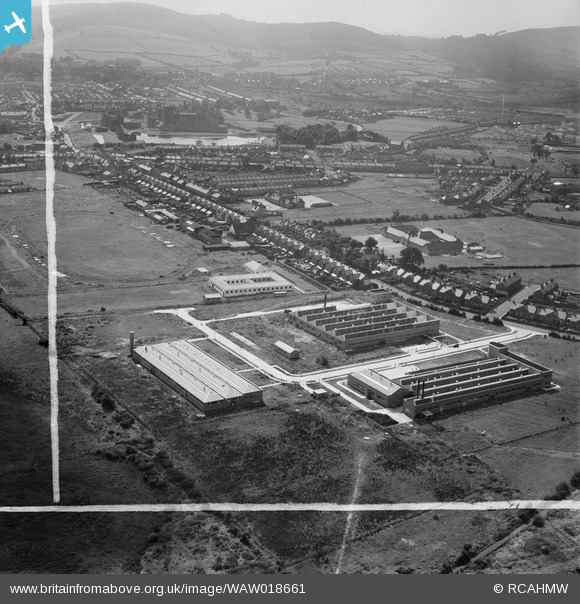
WAW018661 WALES (1948). View of three new factories at Virginia Park, Caerphilly, showing the sports ground
© Copyright OpenStreetMap contributors and licensed by the OpenStreetMap Foundation. 2026. Cartography is licensed as CC BY-SA.
Nearby Images (33)
Details
| Title | [WAW018661] View of three new factories at Virginia Park, Caerphilly, showing the sports ground |
| Reference | WAW018661 |
| Date | 9-September-1948 |
| Link | Coflein Archive Item 6413934 |
| Place name | |
| Parish | |
| District | |
| Country | WALES |
| Easting / Northing | 315700, 186920 |
| Longitude / Latitude | -3.2165926156352, 51.574361161326 |
| National Grid Reference | ST157869 |
Pins

herbie |
Saturday 22nd of August 2015 06:29:48 AM | |

herbie |
Saturday 22nd of August 2015 06:27:46 AM | |

herbie |
Saturday 22nd of August 2015 06:24:52 AM | |

herbie |
Saturday 22nd of August 2015 06:21:46 AM | |

Nantgarw Nomad |
Friday 6th of February 2015 06:10:31 PM | |

Nantgarw Nomad |
Friday 6th of February 2015 06:09:56 PM |


![[WAW007641] View of Caerphilly showing castle. Oblique aerial photograph, 5½" cut roll film.](http://britainfromabove.org.uk/sites/all/libraries/aerofilms-images/public/100x100/WAW/007/WAW007641.jpg)
![[WAW007642] View of Caerphilly showing castle. Oblique aerial photograph, 5½" cut roll film.](http://britainfromabove.org.uk/sites/all/libraries/aerofilms-images/public/100x100/WAW/007/WAW007642.jpg)
![[WAW007643] View of Caerphilly showing castle. Oblique aerial photograph, 5½" cut roll film.](http://britainfromabove.org.uk/sites/all/libraries/aerofilms-images/public/100x100/WAW/007/WAW007643.jpg)
![[WAW007644] View of Caerphilly showing castle. Oblique aerial photograph, 5½" cut roll film.](http://britainfromabove.org.uk/sites/all/libraries/aerofilms-images/public/100x100/WAW/007/WAW007644.jpg)
![[WAW007647] View of Caerphilly showing castle. Oblique aerial photograph, 5½" cut roll film.](http://britainfromabove.org.uk/sites/all/libraries/aerofilms-images/public/100x100/WAW/007/WAW007647.jpg)
![[WAW018008] View of Caerphilly showing castle and housing estates. Oblique aerial photograph, 5½" cut roll film.](http://britainfromabove.org.uk/sites/all/libraries/aerofilms-images/public/100x100/WAW/018/WAW018008.jpg)
![[WAW018009] View of Caerphilly showing castle and housing estates. Oblique aerial photograph, 5½" cut roll film.](http://britainfromabove.org.uk/sites/all/libraries/aerofilms-images/public/100x100/WAW/018/WAW018009.jpg)
![[WAW018010] View of Caerphilly showing castle and housing estates. Oblique aerial photograph, 5½" cut roll film.](http://britainfromabove.org.uk/sites/all/libraries/aerofilms-images/public/100x100/WAW/018/WAW018010.jpg)
![[WAW018660] View of three new factories at Virginia Park, Caerphilly](http://britainfromabove.org.uk/sites/all/libraries/aerofilms-images/public/100x100/WAW/018/WAW018660.jpg)
![[WAW018661] View of three new factories at Virginia Park, Caerphilly, showing the sports ground](http://britainfromabove.org.uk/sites/all/libraries/aerofilms-images/public/100x100/WAW/018/WAW018661.jpg)
![[WAW018662] View of three new factories at Virginia Park, Caerphilly](http://britainfromabove.org.uk/sites/all/libraries/aerofilms-images/public/100x100/WAW/018/WAW018662.jpg)
![[WAW018663] View of three new factories at Virginia Park, Caerphilly](http://britainfromabove.org.uk/sites/all/libraries/aerofilms-images/public/100x100/WAW/018/WAW018663.jpg)
![[WAW018664] View of three new factories at Virginia Park, Caerphilly](http://britainfromabove.org.uk/sites/all/libraries/aerofilms-images/public/100x100/WAW/018/WAW018664.jpg)
![[WAW018665] View of three new factories at Virginia Park, Caerphilly](http://britainfromabove.org.uk/sites/all/libraries/aerofilms-images/public/100x100/WAW/018/WAW018665.jpg)
![[WAW018666] View of three new factories at Virginia Park, Caerphilly](http://britainfromabove.org.uk/sites/all/libraries/aerofilms-images/public/100x100/WAW/018/WAW018666.jpg)
![[WAW018667] View of three new factories at Virginia Park, Caerphilly](http://britainfromabove.org.uk/sites/all/libraries/aerofilms-images/public/100x100/WAW/018/WAW018667.jpg)
![[WAW018668] View of three new factories at Virginia Park, Caerphilly](http://britainfromabove.org.uk/sites/all/libraries/aerofilms-images/public/100x100/WAW/018/WAW018668.jpg)
![[WPW013836] View of Caerphilly showing castle. Oblique aerial photograph, 5"x4" BW glass plate.](http://britainfromabove.org.uk/sites/all/libraries/aerofilms-images/public/100x100/WPW/013/WPW013836.jpg)
![[WPW032443] General view of Caerphilly, oblique aerial view. 5"x4" black and white glass plate negative.](http://britainfromabove.org.uk/sites/all/libraries/aerofilms-images/public/100x100/WPW/032/WPW032443.jpg)
![[WPW032444] General view of Caerphilly, showing castle, oblique aerial view. 5"x4" black and white glass plate negative.](http://britainfromabove.org.uk/sites/all/libraries/aerofilms-images/public/100x100/WPW/032/WPW032444.jpg)
![[WPW032445] General view of Caerphilly, oblique aerial view. 5"x4" black and white glass plate negative.](http://britainfromabove.org.uk/sites/all/libraries/aerofilms-images/public/100x100/WPW/032/WPW032445.jpg)
![[WPW032447] General view of Caerphilly, oblique aerial view. 5"x4" black and white glass plate negative.](http://britainfromabove.org.uk/sites/all/libraries/aerofilms-images/public/100x100/WPW/032/WPW032447.jpg)
![[WPW050477] View of Caerphilly showing school, allotments and castle. Oblique aerial photograph, 5"x4" BW glass plate.](http://britainfromabove.org.uk/sites/all/libraries/aerofilms-images/public/100x100/WPW/050/WPW050477.jpg)
![[WPW050478] View of Caerphilly showing school, allotments and castle. Oblique aerial photograph, 5"x4" BW glass plate.](http://britainfromabove.org.uk/sites/all/libraries/aerofilms-images/public/100x100/WPW/050/WPW050478.jpg)
![[WPW050479] View of Caerphilly showing castle. Oblique aerial photograph, 5"x4" BW glass plate.](http://britainfromabove.org.uk/sites/all/libraries/aerofilms-images/public/100x100/WPW/050/WPW050479.jpg)
![[WPW050481] View of Caerphilly showing castle. Oblique aerial photograph, 5"x4" BW glass plate.](http://britainfromabove.org.uk/sites/all/libraries/aerofilms-images/public/100x100/WPW/050/WPW050481.jpg)
![[WPW050482] View of Caerphilly showing castle. Oblique aerial photograph, 5"x4" BW glass plate.](http://britainfromabove.org.uk/sites/all/libraries/aerofilms-images/public/100x100/WPW/050/WPW050482.jpg)
![[WAW005950] View of Caerphilly showing castle and school](http://britainfromabove.org.uk/sites/all/libraries/aerofilms-images/public/100x100/WAW/005/WAW005950.jpg)
![[WAW005951] View of Caerphilly showing castle and new housing under construction](http://britainfromabove.org.uk/sites/all/libraries/aerofilms-images/public/100x100/WAW/005/WAW005951.jpg)
![[WAW005952] View of Caerphilly showing castle](http://britainfromabove.org.uk/sites/all/libraries/aerofilms-images/public/100x100/WAW/005/WAW005952.jpg)
![[WAW005953] View of Caerphilly showing castle](http://britainfromabove.org.uk/sites/all/libraries/aerofilms-images/public/100x100/WAW/005/WAW005953.jpg)
![[WAW005954] View of Caerphilly showing castle](http://britainfromabove.org.uk/sites/all/libraries/aerofilms-images/public/100x100/WAW/005/WAW005954.jpg)
![[WAW005955] View of Caerphilly showing castle](http://britainfromabove.org.uk/sites/all/libraries/aerofilms-images/public/100x100/WAW/005/WAW005955.jpg)