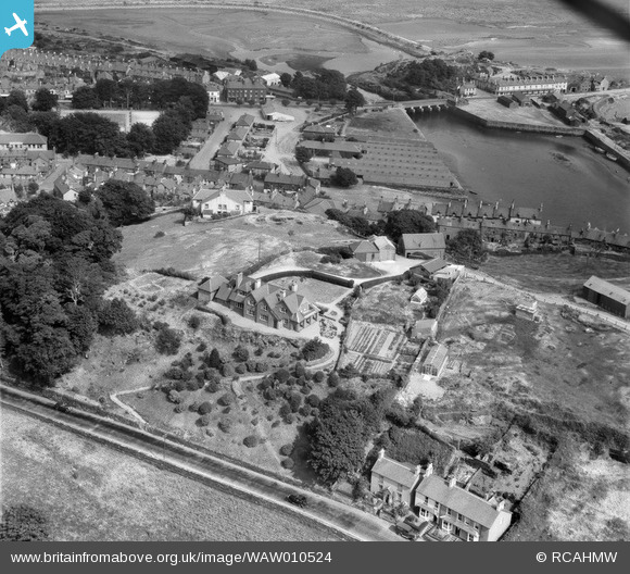
WAW010524 WALES (1947). View of Pen-y-Bryn, Garth, Portmadog, commissioned by S. V. Beer, showing Porthmadog
© Copyright OpenStreetMap contributors and licensed by the OpenStreetMap Foundation. 2026. Cartography is licensed as CC BY-SA.
Nearby Images (9)
Details
| Title | [WAW010524] View of Pen-y-Bryn, Garth, Portmadog, commissioned by S. V. Beer, showing Porthmadog |
| Reference | WAW010524 |
| Date | 30-August-1947 |
| Link | Coflein Archive Item 6413684 |
| Place name | |
| Parish | |
| District | |
| Country | WALES |
| Easting / Northing | 256677, 338306 |
| Longitude / Latitude | -4.1321648743173, 52.922698296483 |
| National Grid Reference | SH567383 |
Pins

John W |
Sunday 9th of August 2020 12:10:57 PM | |

MB |
Friday 25th of April 2014 12:45:03 PM | |

MB |
Friday 25th of April 2014 12:44:38 PM | |

MB |
Friday 25th of April 2014 12:39:48 PM | |

MB |
Friday 25th of April 2014 12:38:34 PM | |
Government Offices including a Tax Office were located here. |

Class31 |
Friday 25th of April 2014 06:02:49 PM |

MB |
Friday 25th of April 2014 12:37:35 PM |


![[WAW010517] View of Pen-y-Bryn, Garth, Portmadog, commissioned by S. V. Beer](http://britainfromabove.org.uk/sites/all/libraries/aerofilms-images/public/100x100/WAW/010/WAW010517.jpg)
![[WAW010518] View of Pen-y-Bryn, Garth, Portmadog, commissioned by S. V. Beer](http://britainfromabove.org.uk/sites/all/libraries/aerofilms-images/public/100x100/WAW/010/WAW010518.jpg)
![[WAW010519] View of Pen-y-Bryn, Garth, Portmadog, commissioned by S. V. Beer](http://britainfromabove.org.uk/sites/all/libraries/aerofilms-images/public/100x100/WAW/010/WAW010519.jpg)
![[WAW010520] View of Pen-y-Bryn, Garth, Portmadog, commissioned by S. V. Beer](http://britainfromabove.org.uk/sites/all/libraries/aerofilms-images/public/100x100/WAW/010/WAW010520.jpg)
![[WAW010521] View of Pen-y-Bryn, Garth, Portmadog, commissioned by S. V. Beer](http://britainfromabove.org.uk/sites/all/libraries/aerofilms-images/public/100x100/WAW/010/WAW010521.jpg)
![[WAW010522] View of Pen-y-Bryn, Garth, Portmadog, commissioned by S. V. Beer, showing the Porthmadog](http://britainfromabove.org.uk/sites/all/libraries/aerofilms-images/public/100x100/WAW/010/WAW010522.jpg)
![[WAW010523] View of Pen-y-Bryn, Garth, Portmadog, commissioned by S. V. Beer](http://britainfromabove.org.uk/sites/all/libraries/aerofilms-images/public/100x100/WAW/010/WAW010523.jpg)
![[WAW010524] View of Pen-y-Bryn, Garth, Portmadog, commissioned by S. V. Beer, showing Porthmadog](http://britainfromabove.org.uk/sites/all/libraries/aerofilms-images/public/100x100/WAW/010/WAW010524.jpg)
![[WAW010525] View of Pen-y-Bryn, Garth, Portmadog, commissioned by S. V. Beer, showing Morfa Lodge & the Catholic church in the background](http://britainfromabove.org.uk/sites/all/libraries/aerofilms-images/public/100x100/WAW/010/WAW010525.jpg)