
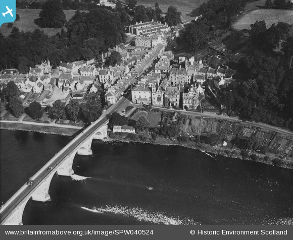
SPW040524 SCOTLAND (1932). Dunkeld, general view, showing Bridge Street and Boat Road. An oblique aerial photograph taken facing north. This image has been produced from a print.
© Copyright OpenStreetMap contributors and licensed by the OpenStreetMap Foundation. 2026. Cartography is licensed as CC BY-SA.
Nearby Images (12)
SPW040524

SPW040523

SPW033672

SPW040526

SAR016728

SAR016729

SAR016730

SPW033669

SAR016726

SAR016727

SPW033667

SPW033668

Details
| Title | [SPW040524] Dunkeld, general view, showing Bridge Street and Boat Road. An oblique aerial photograph taken facing north. This image has been produced from a print. |
| Reference | SPW040524 |
| Date | 1932 |
| Link | NRHE Collection item 1315525 |
| Place name | |
| Parish | DUNKELD AND DOWALLY |
| District | PERTH AND KINROSS |
| Country | SCOTLAND |
| Easting / Northing | 302701, 742599 |
| Longitude / Latitude | -3.5835070986901, 56.565366033972 |
| National Grid Reference | NO027426 |
Pins

Grant Buttars |
Sunday 24th of November 2013 08:33:29 PM |