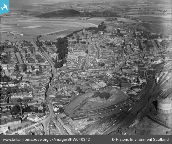
SPW040342 SCOTLAND (1932). Stirling, general view, showing Dumbarton Road and Stirling Castle. An oblique aerial photograph taken facing north-west.
© Copyright OpenStreetMap contributors and licensed by the OpenStreetMap Foundation. 2026. Cartography is licensed as CC BY-SA.
Nearby Images (13)
Details
| Title | [SPW040342] Stirling, general view, showing Dumbarton Road and Stirling Castle. An oblique aerial photograph taken facing north-west. |
| Reference | SPW040342 |
| Date | 1932 |
| Link | NRHE Collection item 1257399 |
| Place name | |
| Parish | STIRLING |
| District | STIRLING |
| Country | SCOTLAND |
| Easting / Northing | 279603, 693405 |
| Longitude / Latitude | -3.9366782863396, 56.118247737014 |
| National Grid Reference | NS796934 |
Pins

elltrain3 |
Wednesday 9th of July 2025 02:05:58 AM | |

gBr |
Friday 27th of November 2015 09:01:42 PM | |

Whitwellian |
Monday 6th of October 2014 04:38:51 PM | |

Speed |
Tuesday 21st of May 2013 12:38:27 AM | |

Speed |
Monday 6th of May 2013 11:05:49 PM |


![[SPW040342] Stirling, general view, showing Dumbarton Road and Stirling Castle. An oblique aerial photograph taken facing north-west.](http://britainfromabove.org.uk/sites/all/libraries/aerofilms-images/public/100x100/SPW/040/SPW040342.jpg)
![[SPW020316] Stirling, general view, showing Port Street, King Street and Albert Halls. An oblique aerial photograph taken facing north.](http://britainfromabove.org.uk/sites/all/libraries/aerofilms-images/public/100x100/SPW/020/SPW020316.jpg)
![[SPW040343] Stirling, general view, showing Spittal Street and Stirling Castle. An oblique aerial photograph taken facing north-west. This image has been produced from a damaged negative.](http://britainfromabove.org.uk/sites/all/libraries/aerofilms-images/public/100x100/SPW/040/SPW040343.jpg)
![[SPW020257] Stirling, general view, showing Stirling Station and South Church. An oblique aerial photograph taken facing north.](http://britainfromabove.org.uk/sites/all/libraries/aerofilms-images/public/100x100/SPW/020/SPW020257.jpg)
![[SPW020255] Stirling, general view, showing Stirling Station and Port Street. An oblique aerial photograph taken facing north.](http://britainfromabove.org.uk/sites/all/libraries/aerofilms-images/public/100x100/SPW/020/SPW020255.jpg)
![[SAR008641] General View Stirling, Stirlingshire, Scotland. An oblique aerial photograph taken facing North/West.](http://britainfromabove.org.uk/sites/all/libraries/aerofilms-images/public/100x100/SAR/008/SAR008641.jpg)
![[SAR008642] General View Stirling, Stirlingshire, Scotland. An oblique aerial photograph taken facing South/West.](http://britainfromabove.org.uk/sites/all/libraries/aerofilms-images/public/100x100/SAR/008/SAR008642.jpg)
![[SAR008643] General View Stirling, Stirlingshire, Scotland. An oblique aerial photograph taken facing South/East.](http://britainfromabove.org.uk/sites/all/libraries/aerofilms-images/public/100x100/SAR/008/SAR008643.jpg)
![[SAR018751] General View Stirling, Stirlingshire, Scotland. An oblique aerial photograph taken facing South/West. This image was marked by AeroPictorial Ltd for photo editing.](http://britainfromabove.org.uk/sites/all/libraries/aerofilms-images/public/100x100/SAR/018/SAR018751.jpg)
![[SAR019988] Vale of Forth with Stirling St Ninians, Stirlingshire, Scotland. An oblique aerial photograph taken facing North/West.](http://britainfromabove.org.uk/sites/all/libraries/aerofilms-images/public/100x100/SAR/019/SAR019988.jpg)
![[SAR023761] General View Stirling, Stirlingshire, Scotland. An oblique aerial photograph taken facing North. This image was marked by AeroPictorial Ltd for photo editing.](http://britainfromabove.org.uk/sites/all/libraries/aerofilms-images/public/100x100/SAR/023/SAR023761.jpg)
![[SPW020253] Stirling, general view, showing Town Wall, Albert Halls and Holy Trinity Episcopal Church. An oblique aerial photograph taken facing north-east.](http://britainfromabove.org.uk/sites/all/libraries/aerofilms-images/public/100x100/SPW/020/SPW020253.jpg)
![[SPW040346] Stirling, general view, showing Spittal Street and Sauchie House. An oblique aerial photograph taken facing west.](http://britainfromabove.org.uk/sites/all/libraries/aerofilms-images/public/100x100/SPW/040/SPW040346.jpg)
