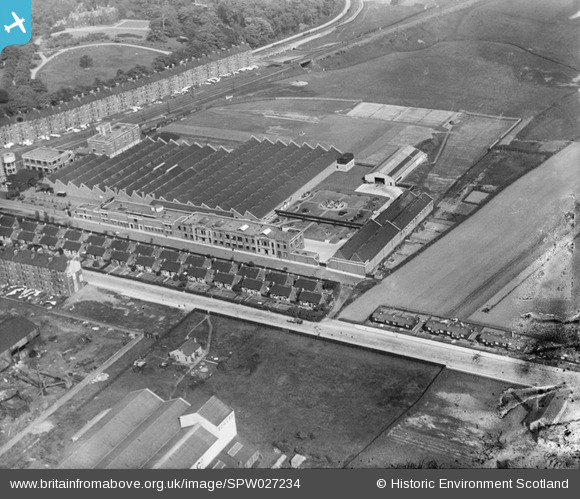
SPW027234 SCOTLAND (1929). Macfarlane, Lang and Co. Biscuit Factory, Clydeford Drive, Glasgow. An oblique aerial photograph taken facing east. This image has been produced from a damaged negative.
© Copyright OpenStreetMap contributors and licensed by the OpenStreetMap Foundation. 2026. Cartography is licensed as CC BY-SA.
Nearby Images (18)
Details
| Title | [SPW027234] Macfarlane, Lang and Co. Biscuit Factory, Clydeford Drive, Glasgow. An oblique aerial photograph taken facing east. This image has been produced from a damaged negative. |
| Reference | SPW027234 |
| Date | 1929 |
| Link | NRHE Collection item 1256808 |
| Place name | |
| Parish | GLASGOW (CITY OF GLASGOW) |
| District | CITY OF GLASGOW |
| Country | SCOTLAND |
| Easting / Northing | 263160, 663450 |
| Longitude / Latitude | -4.1857410332151, 55.844848162765 |
| National Grid Reference | NS632635 |
Pins
Be the first to add a comment to this image!


![[SAW051738] Glasgow, general view, showing Macfarlane, Lang and Co. Victoria Biscuit Works, Clydeford Drive and Clyde Iron Works. An oblique aerial photograph taken facing south. This image has been produced from a crop marked negative.](http://britainfromabove.org.uk/sites/all/libraries/aerofilms-images/public/100x100/SAW/051/SAW051738.jpg)
![[SAW051740] Glasgow, general view, showing Macfarlane, Lang and Co. Victoria Biscuit Works, Clydeford Drive and Clyde Iron Works, with Govancroft Pottery in the background. An oblique aerial photograph taken facing south. This image has been produced fr](http://britainfromabove.org.uk/sites/all/libraries/aerofilms-images/public/100x100/SAW/051/SAW051740.jpg)
![[SAW051744] Glasgow, general view, showing Macfarlane, Lang and Co. Victoria Biscuit Works, Clydeford Drive and Tolcross Road. An oblique aerial photograph taken facing north. This image has been produced from a crop marked negative.](http://britainfromabove.org.uk/sites/all/libraries/aerofilms-images/public/100x100/SAW/051/SAW051744.jpg)
![[SPW027232] Macfarlane, Lang and Co. Biscuit Factory, Clydeford Drive, Glasgow with the Govancroft Pottery in the background. An oblique aerial photograph taken facing south.](http://britainfromabove.org.uk/sites/all/libraries/aerofilms-images/public/100x100/SPW/027/SPW027232.jpg)
![[SPW027233] Macfarlane, Lang and Co. Biscuit Factory, Clydeford Drive, Glasgow. An oblique aerial photograph taken facing east.](http://britainfromabove.org.uk/sites/all/libraries/aerofilms-images/public/100x100/SPW/027/SPW027233.jpg)
![[SPW027234] Macfarlane, Lang and Co. Biscuit Factory, Clydeford Drive, Glasgow. An oblique aerial photograph taken facing east. This image has been produced from a damaged negative.](http://britainfromabove.org.uk/sites/all/libraries/aerofilms-images/public/100x100/SPW/027/SPW027234.jpg)
![[SPW027235] Macfarlane, Lang and Co. Biscuit Factory, Clydeford Drive, Glasgow. An oblique aerial photograph taken facing east.](http://britainfromabove.org.uk/sites/all/libraries/aerofilms-images/public/100x100/SPW/027/SPW027235.jpg)
![[SPW027236] Macfarlane, Lang and Co. Biscuit Factory, Clydeford Drive, Glasgow. An oblique aerial photograph taken facing south-east.](http://britainfromabove.org.uk/sites/all/libraries/aerofilms-images/public/100x100/SPW/027/SPW027236.jpg)
![[SPW027237] Macfarlane, Lang and Co. Biscuit Factory, Clydeford Drive, Glasgow. An oblique aerial photograph taken facing east.](http://britainfromabove.org.uk/sites/all/libraries/aerofilms-images/public/100x100/SPW/027/SPW027237.jpg)
![[SPW027238] Macfarlane, Lang and Co. Biscuit Factory, Clydeford Drive, Glasgow. An oblique aerial photograph taken facing south.](http://britainfromabove.org.uk/sites/all/libraries/aerofilms-images/public/100x100/SPW/027/SPW027238.jpg)
![[SPW027239] Macfarlane, Lang and Co. Biscuit Factory, Clydeford Drive and William Wilson and Co. Lilybank Boiler Works, Glasgow. An oblique aerial photograph taken facing south.](http://britainfromabove.org.uk/sites/all/libraries/aerofilms-images/public/100x100/SPW/027/SPW027239.jpg)
![[SAW035573] Beatson, Clarke and Co, Ltd., Braidfauld, Glasgow, Lanarkshire, Scotland, 1951. An oblique aerial photograph taken facing North.This image was marked by Aerofilms Ltd for photo editing.](http://britainfromabove.org.uk/sites/all/libraries/aerofilms-images/public/100x100/SAW/035/SAW035573.jpg)
![[SPW027255] William Wilson and Co. Lilybank Boiler Works and Macfarlane, Lang and Co. Biscuit Factory, Clydeford Drive, Glasgow. An oblique aerial photograph taken facing east. This image has been produced from a print.](http://britainfromabove.org.uk/sites/all/libraries/aerofilms-images/public/100x100/SPW/027/SPW027255.jpg)
![[SPW027256] William Wilson and Co. Lilybank Boiler Works, Tollcross, Glasgow. An oblique aerial photograph taken facing north.](http://britainfromabove.org.uk/sites/all/libraries/aerofilms-images/public/100x100/SPW/027/SPW027256.jpg)
![[SAW051741] Glasgow, general view, showing Macfarlane, Lang and Co. Victoria Biscuit Works, Clydeford Drive and Tolcross Park. An oblique aerial photograph taken facing east. This image has been produced from a crop marked negative.](http://britainfromabove.org.uk/sites/all/libraries/aerofilms-images/public/100x100/SAW/051/SAW051741.jpg)
![[SAW051742] Glasgow, general view, showing Macfarlane, Lang and Co. Victoria Biscuit Works, Clydeford Drive and Tolcross Park. An oblique aerial photograph taken facing east.](http://britainfromabove.org.uk/sites/all/libraries/aerofilms-images/public/100x100/SAW/051/SAW051742.jpg)
![[SAW051743] Macfarlane, Lang and Co. Victoria Biscuit Works, Clydeford Drive and Tolcross Park, Glasgow. An oblique aerial photograph taken facing east. This image has been produced from a crop marked negative.](http://britainfromabove.org.uk/sites/all/libraries/aerofilms-images/public/100x100/SAW/051/SAW051743.jpg)
![[SAW051745] Macfarlane, Lang and Co. Victoria Biscuit Works, Clydeford Drive and Tolcross Park, Glasgow. An oblique aerial photograph taken facing north-east. This image has been produced from a crop marked negative.](http://britainfromabove.org.uk/sites/all/libraries/aerofilms-images/public/100x100/SAW/051/SAW051745.jpg)