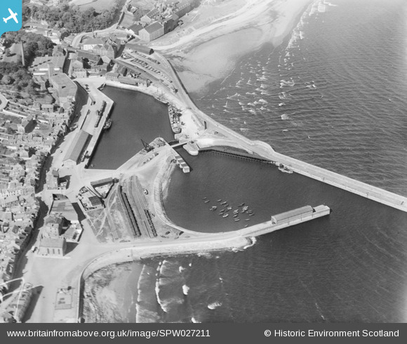
SPW027211 SCOTLAND (1929). Dock and Harbour, Kirkcaldy. An oblique aerial photograph taken facing north-east.
© Copyright OpenStreetMap contributors and licensed by the OpenStreetMap Foundation. 2026. Cartography is licensed as CC BY-SA.
Nearby Images (5)
Details
| Title | [SPW027211] Dock and Harbour, Kirkcaldy. An oblique aerial photograph taken facing north-east. |
| Reference | SPW027211 |
| Date | 1929 |
| Link | NRHE Collection item 1256785 |
| Place name | |
| Parish | KIRKCALDY AND DYSART |
| District | KIRKCALDY |
| Country | SCOTLAND |
| Easting / Northing | 328549, 691932 |
| Longitude / Latitude | -3.1491893113014, 56.11484799811 |
| National Grid Reference | NT285919 |
Pins

Bill Malcolm |
Thursday 6th of April 2017 04:24:07 PM | |

Bill Malcolm |
Thursday 6th of April 2017 04:23:17 PM | |

Bill Malcolm |
Thursday 6th of April 2017 04:21:39 PM | |

Bill Malcolm |
Thursday 6th of April 2017 04:17:52 PM | |

Bill Malcolm |
Thursday 6th of April 2017 04:16:15 PM | |

Bill Malcolm |
Thursday 6th of April 2017 04:13:56 PM | |

Bill Malcolm |
Thursday 6th of April 2017 04:11:54 PM | |

Bill Malcolm |
Wednesday 5th of April 2017 12:59:26 PM | |

Bill Malcolm |
Monday 27th of February 2017 10:08:37 PM |


![[SAR016800] Barry, Ostlere and Shepherd Ltd Kirkcaldy and Dysart, Fife, Scotland. An oblique aerial photograph taken facing North/West. This image was marked by AeroPictorial Ltd for photo editing.](http://britainfromabove.org.uk/sites/all/libraries/aerofilms-images/public/100x100/SAR/016/SAR016800.jpg)
![[SPW027211] Dock and Harbour, Kirkcaldy. An oblique aerial photograph taken facing north-east.](http://britainfromabove.org.uk/sites/all/libraries/aerofilms-images/public/100x100/SPW/027/SPW027211.jpg)
![[SPW027394] Kirkcaldy, general view, showing Harbour and High Street. An oblique aerial photograph taken facing south-east. This image has been produced from a damaged negative.](http://britainfromabove.org.uk/sites/all/libraries/aerofilms-images/public/100x100/SPW/027/SPW027394.jpg)
![[SAW032184] Kirkcaldy, general view, showing Kirkcaldy Harbour and Smeaton. An oblique aerial photograph taken facing north.](http://britainfromabove.org.uk/sites/all/libraries/aerofilms-images/public/100x100/SAW/032/SAW032184.jpg)
![[SAW032185] Kirkcaldy, general view, showing Kirkcaldy Harbour and Beveridge Park. An oblique aerial photograph taken facing west.](http://britainfromabove.org.uk/sites/all/libraries/aerofilms-images/public/100x100/SAW/032/SAW032185.jpg)