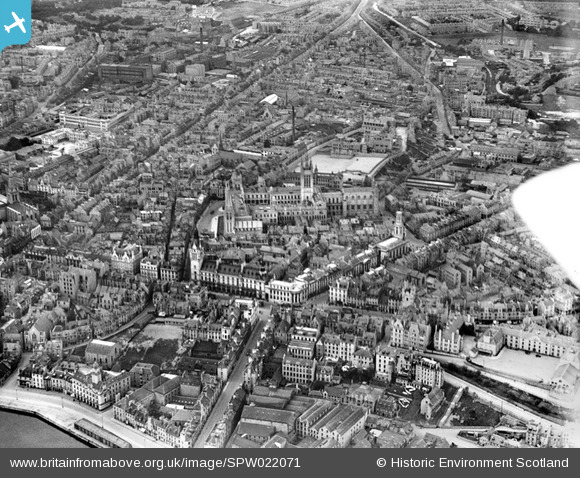
SPW022071 SCOTLAND (1928). Aberdeen, general view, showing University of Aberdeen Marischal College, Town House and Tolbooth. An oblique aerial photograph taken facing north-west.
© Copyright OpenStreetMap contributors and licensed by the OpenStreetMap Foundation. 2026. Cartography is licensed as CC BY-SA.
Nearby Images (19)
Details
| Title | [SPW022071] Aberdeen, general view, showing University of Aberdeen Marischal College, Town House and Tolbooth. An oblique aerial photograph taken facing north-west. |
| Reference | SPW022071 |
| Date | 1928 |
| Link | NRHE Collection item 1256451 |
| Place name | |
| Parish | ABERDEEN |
| District | CITY OF ABERDEEN |
| Country | SCOTLAND |
| Easting / Northing | 394320, 806470 |
| Longitude / Latitude | -2.0938865077935, 57.149262108565 |
| National Grid Reference | NJ943065 |
Pins

toonserjim |
Monday 6th of October 2014 09:58:28 PM | |

toonserjim |
Monday 6th of October 2014 09:57:42 PM | |

toonserjim |
Monday 6th of October 2014 09:55:33 PM | |

toonserjim |
Monday 6th of October 2014 09:54:53 PM | |

toonserjim |
Monday 6th of October 2014 09:54:08 PM |


![[SPW022071] Aberdeen, general view, showing University of Aberdeen Marischal College, Town House and Tolbooth. An oblique aerial photograph taken facing north-west.](http://britainfromabove.org.uk/sites/all/libraries/aerofilms-images/public/100x100/SPW/022/SPW022071.jpg)
![[SAW019605] Aberdeen, general view, showing University of Aberdeen Marischal College and Aberdeen Market. An oblique aerial photograph taken facing north. This image has been produced from a print.](http://britainfromabove.org.uk/sites/all/libraries/aerofilms-images/public/100x100/SAW/019/SAW019605.jpg)
![[SAW019618] Aberdeen, general view, showing St Kirk of St Nicholas, Union Street and University of Aberdeen Marischal College. An oblique aerial photograph taken facing east. This image has been produced from a print.](http://britainfromabove.org.uk/sites/all/libraries/aerofilms-images/public/100x100/SAW/019/SAW019618.jpg)
![[SAW014806] Aberdeen, general view, showing University of Aberdeen Marischal College and Union Street. An oblique aerial photograph taken facing south-east.](http://britainfromabove.org.uk/sites/all/libraries/aerofilms-images/public/100x100/SAW/014/SAW014806.jpg)
![[SPW060050] Aberdeen, general view, showing University of Aberdeen Marischal College and Union Street. An oblique aerial photograph taken facing north.](http://britainfromabove.org.uk/sites/all/libraries/aerofilms-images/public/100x100/SPW/060/SPW060050.jpg)
![[SPW022112] Aberdeen, general view, showing University of Aberdeen Marischal College and West North Street. An oblique aerial photograph taken facing south.](http://britainfromabove.org.uk/sites/all/libraries/aerofilms-images/public/100x100/SPW/022/SPW022112.jpg)
![[SPW022073] Aberdeen, general view, showing University of Aberdeen Marischal College, West North Street and Gallowgate. An oblique aerial photograph taken facing west.](http://britainfromabove.org.uk/sites/all/libraries/aerofilms-images/public/100x100/SPW/022/SPW022073.jpg)
![[SPW022074] Aberdeen, general view, showing University of Aberdeen Marischal College, Town House and Tolbooth. An oblique aerial photograph taken facing north.](http://britainfromabove.org.uk/sites/all/libraries/aerofilms-images/public/100x100/SPW/022/SPW022074.jpg)
![[SAW019619] Aberdeen, general view, showing Robert Gordon's College, Schoolhill and University of Aberdeen Marischal College. An oblique aerial photograph taken facing east. This image has been produced from a print.](http://britainfromabove.org.uk/sites/all/libraries/aerofilms-images/public/100x100/SAW/019/SAW019619.jpg)
![[SPW060049] Aberdeen, general view, showing University of Aberdeen Marischal College and George Street. An oblique aerial photograph taken facing north-west.](http://britainfromabove.org.uk/sites/all/libraries/aerofilms-images/public/100x100/SPW/060/SPW060049.jpg)
![[SAW019603] Aberdeen, general view, showing Kirk of St Nicholas, Union Street and Aberdeen Market. An oblique aerial photograph taken facing east. This image has been produced from a crop marked print.](http://britainfromabove.org.uk/sites/all/libraries/aerofilms-images/public/100x100/SAW/019/SAW019603.jpg)
![[SAW019606] Aberdeen, general view, showing Kirk of St Nicholas, Union Street and George Street. An oblique aerial photograph taken facing north-west. This image has been produced from a print.](http://britainfromabove.org.uk/sites/all/libraries/aerofilms-images/public/100x100/SAW/019/SAW019606.jpg)
![[SAW019599] Aberdeen, general view, showing Kirk of St Nicholas, Union Street and Victoria Dock. An oblique aerial photograph taken facing east.](http://britainfromabove.org.uk/sites/all/libraries/aerofilms-images/public/100x100/SAW/019/SAW019599.jpg)
![[SAW014826] Aberdeen, general view, showing Victoria Dock and George Street. An oblique aerial photograph taken facing north. This image has been produced from a print.](http://britainfromabove.org.uk/sites/all/libraries/aerofilms-images/public/100x100/SAW/014/SAW014826.jpg)
![[SAW019602] Aberdeen, general view, showing Kirk of St Nicholas, Union Street and Victoria Dock. An oblique aerial photograph taken facing east. This image has been produced from a print.](http://britainfromabove.org.uk/sites/all/libraries/aerofilms-images/public/100x100/SAW/019/SAW019602.jpg)
![[SPW060052] Aberdeen, general view, showing University of Aberdeen Marischal College and King Street. An oblique aerial photograph taken facing north.](http://britainfromabove.org.uk/sites/all/libraries/aerofilms-images/public/100x100/SPW/060/SPW060052.jpg)
![[SAW019612] Kirk of St Nicholas, Union Street, Aberdeen. An oblique aerial photograph taken facing east. This image has been produced from a print.](http://britainfromabove.org.uk/sites/all/libraries/aerofilms-images/public/100x100/SAW/019/SAW019612.jpg)
![[SAW022574] Aberdeen, general view, showing Hutcheon Street and Aberdeen Harbour. An oblique aerial photograph taken facing south-east.](http://britainfromabove.org.uk/sites/all/libraries/aerofilms-images/public/100x100/SAW/022/SAW022574.jpg)
![[SPW022072] Aberdeen, general view, showing Kirk of St Nicholas, George Street and Robert Gordon's College. An oblique aerial photograph taken facing north.](http://britainfromabove.org.uk/sites/all/libraries/aerofilms-images/public/100x100/SPW/022/SPW022072.jpg)