
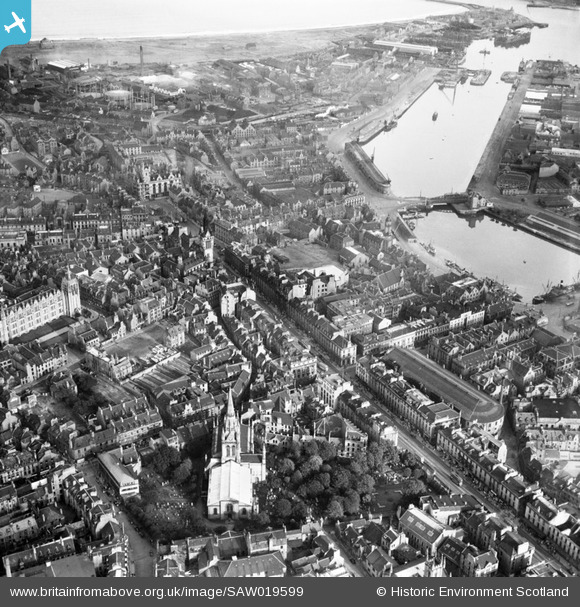
SAW019599 SCOTLAND (1948). Aberdeen, general view, showing Kirk of St Nicholas, Union Street and Victoria Dock. An oblique aerial photograph taken facing east.
© Copyright OpenStreetMap contributors and licensed by the OpenStreetMap Foundation. 2026. Cartography is licensed as CC BY-SA.
Nearby Images (28)
SAW019599

SAW019602

SAW019607

SAW014826

SAW019603

SAW019601

SAW022551

SAW022555

SAW022556

SAW022557

SAW022553

SAW022552

SAW022554

SAW014827

SAW022558

SAW019606

SAW022563

SAW022560

SAW022564

SAW022562

SAW022561

SAW019618

SAW019605

SAW019612

SPW022071

SPW022072

SPW060049

SPW060052

Details
| Title | [SAW019599] Aberdeen, general view, showing Kirk of St Nicholas, Union Street and Victoria Dock. An oblique aerial photograph taken facing east. |
| Reference | SAW019599 |
| Date | 1948 |
| Link | NRHE Collection item 1269167 |
| Place name | |
| Parish | ABERDEEN |
| District | CITY OF ABERDEEN |
| Country | SCOTLAND |
| Easting / Northing | 394300, 806250 |
| Longitude / Latitude | -2.0942120703821, 57.147285365153 |
| National Grid Reference | NJ943063 |
Pins

NorthChurch |
Monday 13th of April 2020 03:03:40 PM |