
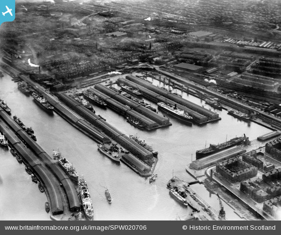
SPW020706 SCOTLAND (1928). Prince's Dock, Glasgow. An oblique aerial photograph taken facing south.
© Copyright OpenStreetMap contributors and licensed by the OpenStreetMap Foundation. 2026. Cartography is licensed as CC BY-SA.
Nearby Images (14)
SPW020706

SPW022183

SPW027222

SPW027223

SPW027225

SPW027227

SPW022255

SPW027224

SPW045889

SPW050833

SAW017937

SPW022184

SPW027221

SPW027231

Details
| Title | [SPW020706] Prince's Dock, Glasgow. An oblique aerial photograph taken facing south. |
| Reference | SPW020706 |
| Date | 1928 |
| Link | NRHE Collection item 1256405 |
| Place name | |
| Parish | GOVAN (CITY OF GLASGOW) |
| District | CITY OF GLASGOW |
| Country | SCOTLAND |
| Easting / Northing | 256580, 664958 |
| Longitude / Latitude | -4.2915478867896, 55.856477252771 |
| National Grid Reference | NS566650 |
Pins

yes |
Friday 21st of March 2025 10:47:39 PM | |
|
yes |
Tuesday 22nd of November 2022 09:25:51 AM | |
|
yes |
Tuesday 22nd of November 2022 09:24:43 AM | |
|
yes |
Tuesday 13th of September 2022 09:56:23 PM | |
|
yes |
Tuesday 13th of September 2022 09:55:42 PM | |
|
Mrpaulj |
Thursday 1st of December 2016 09:39:55 PM | |
|
Mrpaulj |
Thursday 1st of December 2016 09:39:09 PM | |
|
Mrpaulj |
Thursday 1st of December 2016 09:38:27 PM | |
|
Mrpaulj |
Thursday 1st of December 2016 09:37:25 PM | |
|
Mrpaulj |
Thursday 1st of December 2016 09:37:21 PM |