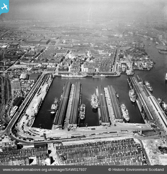
SAW017937 SCOTLAND (1948). Prince's Dock, Glasgow. An oblique aerial photograph taken facing west.
© Copyright OpenStreetMap contributors and licensed by the OpenStreetMap Foundation. 2026. Cartography is licensed as CC BY-SA.
Nearby Images (19)
Details
| Title | [SAW017937] Prince's Dock, Glasgow. An oblique aerial photograph taken facing west. |
| Reference | SAW017937 |
| Date | 1948 |
| Link | NRHE Collection item 1269113 |
| Place name | |
| Parish | GOVAN (CITY OF GLASGOW) |
| District | CITY OF GLASGOW |
| Country | SCOTLAND |
| Easting / Northing | 256390, 665000 |
| Longitude / Latitude | -4.2946031856558, 55.856797822976 |
| National Grid Reference | NS564650 |
Pins

Billy Turner |
Sunday 17th of May 2020 12:18:10 AM | |

Chrissy |
Saturday 18th of April 2020 04:55:10 PM | |

Chrissy |
Saturday 18th of April 2020 04:54:19 PM | |

Chrissy |
Saturday 18th of April 2020 04:53:22 PM | |

Chrissy |
Saturday 18th of April 2020 04:51:46 PM | |

Chrissy |
Saturday 18th of April 2020 04:50:09 PM | |

Class31 |
Sunday 7th of April 2013 09:43:45 PM | |

Gerry_R |
Friday 16th of November 2012 10:01:04 AM |


![[SAW017937] Prince's Dock, Glasgow. An oblique aerial photograph taken facing west.](http://britainfromabove.org.uk/sites/all/libraries/aerofilms-images/public/100x100/SAW/017/SAW017937.jpg)
![[SAR014706] Prince's Dock and River Clyde Glasgow, Lanarkshire, Scotland. An oblique aerial photograph taken facing North/West. This image was marked by AeroPictorial Ltd for photo editing.](http://britainfromabove.org.uk/sites/all/libraries/aerofilms-images/public/100x100/SAR/014/SAR014706.jpg)
![[SAR014708] River Kelvin and West Basin foreground to Prince's Dock Govan, Lanarkshire, Scotland. An oblique aerial photograph taken facing South/East. This image was marked by AeroPictorial Ltd for photo editing.](http://britainfromabove.org.uk/sites/all/libraries/aerofilms-images/public/100x100/SAR/014/SAR014708.jpg)
![[SAR014828] Prince's Dock looking West Glasgow, Lanarkshire, Scotland. An oblique aerial photograph taken facing West.](http://britainfromabove.org.uk/sites/all/libraries/aerofilms-images/public/100x100/SAR/014/SAR014828.jpg)
![[SPW019471] Prince's Dock, Glasgow. An oblique aerial photograph taken facing north.](http://britainfromabove.org.uk/sites/all/libraries/aerofilms-images/public/100x100/SPW/019/SPW019471.jpg)
![[SPW019473] Prince's Dock, Glasgow. An oblique aerial photograph taken facing north.](http://britainfromabove.org.uk/sites/all/libraries/aerofilms-images/public/100x100/SPW/019/SPW019473.jpg)
![[SPW022181] Queen's Dock and Prince's Dock, Glasgow. An oblique aerial photograph taken facing east.](http://britainfromabove.org.uk/sites/all/libraries/aerofilms-images/public/100x100/SPW/022/SPW022181.jpg)
![[SPW027228] Prince's Dock, Glasgow. An oblique aerial photograph taken facing east.](http://britainfromabove.org.uk/sites/all/libraries/aerofilms-images/public/100x100/SPW/027/SPW027228.jpg)
![[SPW020706] Prince's Dock, Glasgow. An oblique aerial photograph taken facing south.](http://britainfromabove.org.uk/sites/all/libraries/aerofilms-images/public/100x100/SPW/020/SPW020706.jpg)
![[SPW022183] Queen's Dock and Prince's Dock, Glasgow. An oblique aerial photograph taken facing north-east.](http://britainfromabove.org.uk/sites/all/libraries/aerofilms-images/public/100x100/SPW/022/SPW022183.jpg)
![[SPW027222] Prince's Dock and Queen's Dock, Glasgow. An oblique aerial photograph taken facing north.](http://britainfromabove.org.uk/sites/all/libraries/aerofilms-images/public/100x100/SPW/027/SPW027222.jpg)
![[SPW027223] Prince's Dock, Glasgow. An oblique aerial photograph taken facing north-west.](http://britainfromabove.org.uk/sites/all/libraries/aerofilms-images/public/100x100/SPW/027/SPW027223.jpg)
![[SPW027225] Prince's Dock, Glasgow. An oblique aerial photograph taken facing north-west.](http://britainfromabove.org.uk/sites/all/libraries/aerofilms-images/public/100x100/SPW/027/SPW027225.jpg)
![[SPW027227] Prince's Dock, Glasgow. An oblique aerial photograph taken facing north-west.](http://britainfromabove.org.uk/sites/all/libraries/aerofilms-images/public/100x100/SPW/027/SPW027227.jpg)
![[SPW027224] Prince's Dock, Glasgow. An oblique aerial photograph taken facing north.](http://britainfromabove.org.uk/sites/all/libraries/aerofilms-images/public/100x100/SPW/027/SPW027224.jpg)
![[SPW027231] Prince's Dock and Queen's Dock, Glasgow. An oblique aerial photograph taken facing east. This image has been produced from a damaged negative.](http://britainfromabove.org.uk/sites/all/libraries/aerofilms-images/public/100x100/SPW/027/SPW027231.jpg)
![[SPW050833] Prince's Dock, Glasgow. An oblique aerial photograph taken facing north.](http://britainfromabove.org.uk/sites/all/libraries/aerofilms-images/public/100x100/SPW/050/SPW050833.jpg)
![[SPW022255] Glasgow, general view, showing Prince's Dock and River Clyde. An oblique aerial photograph taken facing east. The image is double exposed, also showing Cochran's Boiler Works, Newbie, Annan.](http://britainfromabove.org.uk/sites/all/libraries/aerofilms-images/public/100x100/SPW/022/SPW022255.jpg)
![[SPW045889] Prince's Dock, Glasgow. An oblique aerial photograph taken facing north.](http://britainfromabove.org.uk/sites/all/libraries/aerofilms-images/public/100x100/SPW/045/SPW045889.jpg)
