
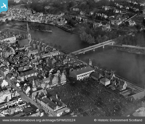
SPW020124 SCOTLAND (1927). Perth, general view, showing Queen's Bridge, St Matthew's Church and Greyfriars Burial Ground. An oblique aerial photograph taken facing north-east.
© Copyright OpenStreetMap contributors and licensed by the OpenStreetMap Foundation. 2026. Cartography is licensed as CC BY-SA.
Nearby Images (11)
SPW020124

SPW040514

SPW040515

SAW022530

SAW022532

SAW022533

SAW022535

SAW022531

SPW020126

SAW022534

SAW022536

Details
| Title | [SPW020124] Perth, general view, showing Queen's Bridge, St Matthew's Church and Greyfriars Burial Ground. An oblique aerial photograph taken facing north-east. |
| Reference | SPW020124 |
| Date | 1927 |
| Link | NRHE Collection item 1246417 |
| Place name | |
| Parish | PERTH |
| District | PERTH AND KINROSS |
| Country | SCOTLAND |
| Easting / Northing | 312166, 723433 |
| Longitude / Latitude | -3.4230664870952, 56.395077861015 |
| National Grid Reference | NO122234 |
Pins

doug |
Tuesday 31st of December 2013 08:26:14 PM | |
|
doug |
Tuesday 31st of December 2013 08:23:48 PM | |

Class31 |
Friday 16th of November 2012 03:28:23 PM | |
|
Class31 |
Friday 16th of November 2012 03:28:01 PM | |
|
Class31 |
Friday 16th of November 2012 03:27:36 PM | |
|
Class31 |
Friday 16th of November 2012 03:24:32 PM | |
|
Class31 |
Friday 16th of November 2012 03:23:59 PM | |
|
Class31 |
Friday 16th of November 2012 03:20:58 PM | |
|
Class31 |
Friday 16th of November 2012 03:19:04 PM |
User Comment Contributions
Stanners Island |
doug |
Tuesday 31st of December 2013 08:24:58 PM |
Queens Bridge was opened in 1960, replacing the Victoria Bridge which is shown here. |
doug |
Tuesday 31st of December 2013 08:21:29 PM |
The bridge as shown is the Victoria bridge which was replaced in the 1960s by the new Queen's Bridge |
bill |
Friday 29th of June 2012 11:25:19 AM |
the bridge was the victoria bridge which was replaced by the queens bridge in 1960 |
rod |
Tuesday 26th of June 2012 10:27:34 PM |