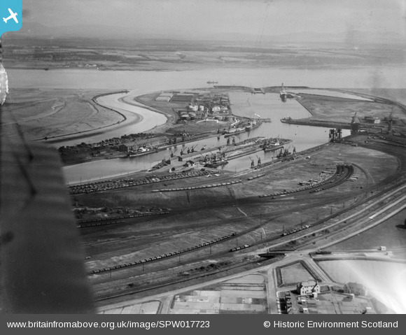
SPW017723 SCOTLAND (1927). Grangemouth Docks and Harbour. An oblique aerial photograph taken facing north.
© Copyright OpenStreetMap contributors and licensed by the OpenStreetMap Foundation. 2026. Cartography is licensed as CC BY-SA.
Nearby Images (5)
Details
| Title | [SPW017723] Grangemouth Docks and Harbour. An oblique aerial photograph taken facing north. |
| Reference | SPW017723 |
| Date | 1927 |
| Link | NRHE Collection item 1256149 |
| Place name | |
| Parish | GRANGEMOUTH |
| District | FALKIRK |
| Country | SCOTLAND |
| Easting / Northing | 294100, 682660 |
| Longitude / Latitude | -3.6993538950317, 56.025174582141 |
| National Grid Reference | NS941827 |
Pins

MB |
Monday 17th of September 2012 10:13:17 AM | |

MB |
Monday 17th of September 2012 10:13:10 AM | |

patoflarbert |
Wednesday 25th of July 2012 08:20:27 AM | |

patoflarbert |
Wednesday 25th of July 2012 08:18:37 AM | |

patoflarbert |
Wednesday 25th of July 2012 08:16:19 AM | |

cell |
Monday 23rd of July 2012 09:05:47 PM |
User Comment Contributions

AlMu |
Monday 24th of December 2012 03:12:17 PM | |
Grangemouth was the port used in World War I to supply Sir John Jellicoe's Grand Fleet at Scapa Flow in the Orkney Islands with coal. The coal was hauled by 'Jellicoe Specials' running day and night throughout much of the war from South Wales. Only Welsh coal was good enough for the Royal Navy's steam-powered warships. For further details see Keith Turton's 'Admiralty Coal Traffic during the First World War. The 'Jellicoe Trains' Parts 1 and 2', Railway Archive, 19 and 20, Lightmoor Press, 2008. Or my shorter account in Back Track, vol 20, no 8, August 2006 |

MB |
Monday 17th of September 2012 10:25:43 AM |

cell |
Monday 23rd of July 2012 09:06:28 PM |


![[SPW017723] Grangemouth Docks and Harbour. An oblique aerial photograph taken facing north.](http://britainfromabove.org.uk/sites/all/libraries/aerofilms-images/public/100x100/SPW/017/SPW017723.jpg)
![[SAR014802] General View Grangemouth, Stirlingshire, Scotland. An oblique aerial photograph taken facing North. This image was marked by AeroPictorial Ltd for photo editing.](http://britainfromabove.org.uk/sites/all/libraries/aerofilms-images/public/100x100/SAR/014/SAR014802.jpg)
![[SAR014803] General View of docks Grangemouth, Stirlingshire, Scotland. An oblique aerial photograph taken facing West. This image was marked by AeroPictorial Ltd for photo editing.](http://britainfromabove.org.uk/sites/all/libraries/aerofilms-images/public/100x100/SAR/014/SAR014803.jpg)
![[SAR014804] General View of docks Grangemouth, Stirlingshire, Scotland. An oblique aerial photograph taken facing East. This image was marked by AeroPictorial Ltd for photo editing.](http://britainfromabove.org.uk/sites/all/libraries/aerofilms-images/public/100x100/SAR/014/SAR014804.jpg)
![[SAW018838] Grangemouth, general view, showing Grange Dock and Forth and Clyde Canal. An oblique aerial photograph taken facing west. This image has been produced from a print.](http://britainfromabove.org.uk/sites/all/libraries/aerofilms-images/public/100x100/SAW/018/SAW018838.jpg)
