
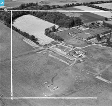
SAW048179 SCOTLAND (1953). Newbyth Mains and Walled Garden, Whitekirk. An oblique aerial photograph taken facing north. This image has been produced from a crop marked negative.

© Copyright OpenStreetMap contributors and licensed by the OpenStreetMap Foundation. 2026. Cartography is licensed as CC BY-SA.
Nearby Images (7)
SAW048175

SAW048177

SAW048179

SAW048181

SAW048183

SAW048174

SAW048176

Details
| Title | [SAW048179] Newbyth Mains and Walled Garden, Whitekirk. An oblique aerial photograph taken facing north. This image has been produced from a crop marked negative. |
| Reference | SAW048179 |
| Date | 1953 |
| Link | NRHE Collection item 1297849 |
| Place name | |
| Parish | WHITEKIRK AND TYNINGHAME |
| District | EAST LOTHIAN |
| Country | SCOTLAND |
| Easting / Northing | 358550, 680330 |
| Longitude / Latitude | -2.6649185674865, 56.014149828439 |
| National Grid Reference | NT586803 |
Pins

Maurice |
Monday 13th of May 2013 07:40:37 AM | |
|
Maurice |
Monday 13th of May 2013 07:29:20 AM | |
|
Maurice |
Monday 13th of May 2013 07:27:45 AM | |
|
Maurice |
Monday 13th of May 2013 07:26:18 AM |
User Comment Contributions
farm buildings |

Farm Buildings |
Wednesday 25th of September 2013 02:01:46 PM |