
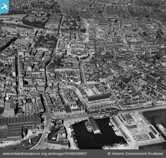
SAW009822 SCOTLAND (1947). Dundee, general view, showing Caird Hall and Dundee Royal Infirmary, Barrack Road. An oblique aerial photograph taken facing north.
© Copyright OpenStreetMap contributors and licensed by the OpenStreetMap Foundation. 2026. Cartography is licensed as CC BY-SA.
Nearby Images (19)
SAW009822

SAW014833

SAW014835

SPW019930

SAW051265

SPW060072

SPW019935

SAW019553

SAW019554

SAW051263

SAW019548

SPW060076

SPW060073

SPW019925

SPW060074

SPW060075

SAW019551

SPW040561

SPW042547

Details
| Title | [SAW009822] Dundee, general view, showing Caird Hall and Dundee Royal Infirmary, Barrack Road. An oblique aerial photograph taken facing north. |
| Reference | SAW009822 |
| Date | 1947 |
| Link | NRHE Collection item 1268665 |
| Place name | |
| Parish | DUNDEE (DUNDEE, CITY OF) |
| District | CITY OF DUNDEE |
| Country | SCOTLAND |
| Easting / Northing | 340258, 730296 |
| Longitude / Latitude | -2.9695847743468, 56.461120364988 |
| National Grid Reference | NO403303 |
Pins

gBr |
Wednesday 9th of September 2015 06:44:00 PM | |
|
gBr |
Wednesday 9th of September 2015 06:42:59 PM | |
|
mtbhulls |
Friday 17th of January 2014 04:57:29 PM | |
|
mtbhulls |
Friday 17th of January 2014 04:56:31 PM | |
|
mtbhulls |
Friday 17th of January 2014 04:55:51 PM |