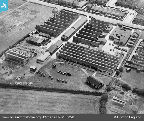
EPW062241 ENGLAND (1939). Henry Hughes and Son Husun Nautical Instrument Works, Fairlop, 1939
© Copyright OpenStreetMap contributors and licensed by the OpenStreetMap Foundation. 2026. Cartography is licensed as CC BY-SA.
Nearby Images (5)
Details
| Title | [EPW062241] Henry Hughes and Son Husun Nautical Instrument Works, Fairlop, 1939 |
| Reference | EPW062241 |
| Date | 25-July-1939 |
| Link | |
| Place name | FAIRLOP |
| Parish | |
| District | |
| Country | ENGLAND |
| Easting / Northing | 544717, 191515 |
| Longitude / Latitude | 0.08991390285014, 51.603381886917 |
| National Grid Reference | TQ447915 |
Pins
Katy Whitaker |
Thursday 5th of September 2013 11:35:14 PM | |
Perhaps the construction of Air Raid Shelters? |

Matt Aldred edob.mattaldred.com |
Sunday 3rd of May 2020 04:47:15 PM |

Jenny Karling |
Thursday 5th of September 2013 07:27:29 PM |


![[EPW062241] Henry Hughes and Son Husun Nautical Instrument Works, Fairlop, 1939](http://britainfromabove.org.uk/sites/all/libraries/aerofilms-images/public/100x100/EPW/062/EPW062241.jpg)
![[EPW062233] New North Road and environs, Fairlop, 1939](http://britainfromabove.org.uk/sites/all/libraries/aerofilms-images/public/100x100/EPW/062/EPW062233.jpg)
![[EPW062242] Henry Hughes and Son Husun Nautical Instrument Works, Fairlop, 1939](http://britainfromabove.org.uk/sites/all/libraries/aerofilms-images/public/100x100/EPW/062/EPW062242.jpg)
![[EPW062234] Henry Hughes and Son Husun Nautical Instrument Works, Fairlop, 1939](http://britainfromabove.org.uk/sites/all/libraries/aerofilms-images/public/100x100/EPW/062/EPW062234.jpg)
![[EPW062232] New North Road and environs, Fairlop, 1939](http://britainfromabove.org.uk/sites/all/libraries/aerofilms-images/public/100x100/EPW/062/EPW062232.jpg)