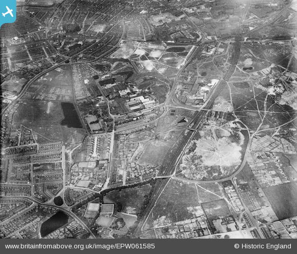
EPW061585 ENGLAND (1939). The Ravenhead Glass Works and the surrounding industrial area, St Helens, 1939
© Copyright OpenStreetMap contributors and licensed by the OpenStreetMap Foundation. 2026. Cartography is licensed as CC BY-SA.
Nearby Images (25)
Details
| Title | [EPW061585] The Ravenhead Glass Works and the surrounding industrial area, St Helens, 1939 |
| Reference | EPW061585 |
| Date | 4-June-1939 |
| Link | |
| Place name | ST HELENS |
| Parish | |
| District | |
| Country | ENGLAND |
| Easting / Northing | 350150, 394243 |
| Longitude / Latitude | -2.7505775765906, 53.442341562627 |
| National Grid Reference | SJ502942 |
Pins

St Helens Pubs |
Saturday 11th of January 2014 11:26:19 AM | |
My grandad ran the Alex in St. Helens, after he retired from the police. His name was David kidd? Pub had a bowling green at the back. Is this the same pub? Would be v interested to know thanks |

Aliwarbo |
Saturday 1st of March 2014 07:53:29 PM |

pauloyick |
Thursday 2nd of January 2014 03:54:48 PM | |

pauloyick |
Thursday 2nd of January 2014 03:54:02 PM |


![[EPW061585] The Ravenhead Glass Works and the surrounding industrial area, St Helens, 1939](http://britainfromabove.org.uk/sites/all/libraries/aerofilms-images/public/100x100/EPW/061/EPW061585.jpg)
![[EPW061586] The Ravenhead Glass Works and the surrounding industrial area, St Helens, 1939](http://britainfromabove.org.uk/sites/all/libraries/aerofilms-images/public/100x100/EPW/061/EPW061586.jpg)
![[EPW061561] The Greengate Brick and Tile Works, Alexandra Colliery and the Ravenhead Works, St Helens, 1939](http://britainfromabove.org.uk/sites/all/libraries/aerofilms-images/public/100x100/EPW/061/EPW061561.jpg)
![[EPW061582] The Ravenhead Glass Works and the surrounding industrial area, St Helens, 1939](http://britainfromabove.org.uk/sites/all/libraries/aerofilms-images/public/100x100/EPW/061/EPW061582.jpg)
![[EPW061560] The Greengate Brick and Tile Works, Alexandra Colliery and the Ravenhead Works, St Helens, 1939](http://britainfromabove.org.uk/sites/all/libraries/aerofilms-images/public/100x100/EPW/061/EPW061560.jpg)
![[EPW009307] The Ravenhead Plate Glass Works, St Helens, 1923](http://britainfromabove.org.uk/sites/all/libraries/aerofilms-images/public/100x100/EPW/009/EPW009307.jpg)
![[EPW061587] The Ravenhead Glass Works and the Greengate Brick and Tile Works, St Helens, 1939](http://britainfromabove.org.uk/sites/all/libraries/aerofilms-images/public/100x100/EPW/061/EPW061587.jpg)
![[EPW061589] The Ravenhead Glass Works, St Helens, 1939](http://britainfromabove.org.uk/sites/all/libraries/aerofilms-images/public/100x100/EPW/061/EPW061589.jpg)
![[EPW009304] The Ravenhead Plate Glass Works, St Helens, 1923](http://britainfromabove.org.uk/sites/all/libraries/aerofilms-images/public/100x100/EPW/009/EPW009304.jpg)
![[EPW009303] The Ravenhead Plate Glass Works and environs, St Helens, 1923](http://britainfromabove.org.uk/sites/all/libraries/aerofilms-images/public/100x100/EPW/009/EPW009303.jpg)
![[EAW012376] The Pilkington Brothers Ravenhead Glass Works, St Helens, 1947. This image has been produced from a print.](http://britainfromabove.org.uk/sites/all/libraries/aerofilms-images/public/100x100/EAW/012/EAW012376.jpg)
![[EPW061584] The Ravenhead Glass Works and the surrounding industrial area, St Helens, 1939](http://britainfromabove.org.uk/sites/all/libraries/aerofilms-images/public/100x100/EPW/061/EPW061584.jpg)
![[EAW012375] The Pilkington Brothers Ravenhead Glass Works, St Helens, from the south-east, 1947. This image has been produced from a damaged negative.](http://britainfromabove.org.uk/sites/all/libraries/aerofilms-images/public/100x100/EAW/012/EAW012375.jpg)
![[EPW061593] The Ravenhead Glass Works, St Helens, 1939](http://britainfromabove.org.uk/sites/all/libraries/aerofilms-images/public/100x100/EPW/061/EPW061593.jpg)
![[EPW009308] The Ravenhead Plate Glass Works, St Helens, 1923](http://britainfromabove.org.uk/sites/all/libraries/aerofilms-images/public/100x100/EPW/009/EPW009308.jpg)
![[EPW009305] The Ravenhead Plate Glass Works, St Helens, 1923](http://britainfromabove.org.uk/sites/all/libraries/aerofilms-images/public/100x100/EPW/009/EPW009305.jpg)
![[EPW009305A] The Ravenhead Plate Glass Works, St Helens, 1923](http://britainfromabove.org.uk/sites/all/libraries/aerofilms-images/public/100x100/EPW/009/EPW009305A.jpg)
![[EPW009301] Greengate Brick and Tile Works, St Helens, 1923](http://britainfromabove.org.uk/sites/all/libraries/aerofilms-images/public/100x100/EPW/009/EPW009301.jpg)
![[EPW009296] Greengate Brick and Tile Works and environs, St Helens, 1923](http://britainfromabove.org.uk/sites/all/libraries/aerofilms-images/public/100x100/EPW/009/EPW009296.jpg)
![[EPW009297] Greengate Brick and Tile Works and environs, St Helens, 1923](http://britainfromabove.org.uk/sites/all/libraries/aerofilms-images/public/100x100/EPW/009/EPW009297.jpg)
![[EPW009300] Greengate Brick and Tile Works, St Helens, 1923](http://britainfromabove.org.uk/sites/all/libraries/aerofilms-images/public/100x100/EPW/009/EPW009300.jpg)
![[EAW012377] The Pilkington Brothers Ravenhead Glass Works, St Helens, 1947. This image has been produced from a print.](http://britainfromabove.org.uk/sites/all/libraries/aerofilms-images/public/100x100/EAW/012/EAW012377.jpg)
![[EPW009298] Greengate Brick and Tile Works, St Helens, 1923](http://britainfromabove.org.uk/sites/all/libraries/aerofilms-images/public/100x100/EPW/009/EPW009298.jpg)
![[EPW009299] Greengate Tile and Brick Works, St Helens, 1923](http://britainfromabove.org.uk/sites/all/libraries/aerofilms-images/public/100x100/EPW/009/EPW009299.jpg)
![[EPW061583] The Ravenhead Glass Works and the surrounding industrial area, St Helens, 1939](http://britainfromabove.org.uk/sites/all/libraries/aerofilms-images/public/100x100/EPW/061/EPW061583.jpg)