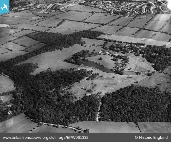
EPW061332 ENGLAND (1939). Trent Park, Enfield, 1939
© Copyright OpenStreetMap contributors and licensed by the OpenStreetMap Foundation. 2026. Cartography is licensed as CC BY-SA.
Details
| Title | [EPW061332] Trent Park, Enfield, 1939 |
| Reference | EPW061332 |
| Date | 2-June-1939 |
| Link | |
| Place name | ENFIELD |
| Parish | |
| District | |
| Country | ENGLAND |
| Easting / Northing | 529121, 197604 |
| Longitude / Latitude | -0.13293134955694, 51.661899600047 |
| National Grid Reference | TQ291976 |
Pins

Lee P |
Monday 7th of October 2019 05:34:47 PM | |

David |
Sunday 12th of January 2014 06:15:03 PM | |

David |
Sunday 12th of January 2014 06:05:29 PM | |

Macmartyn |
Monday 4th of November 2013 02:27:15 PM | |

Macmartyn |
Monday 4th of November 2013 02:20:53 PM | |

Macmartyn |
Monday 4th of November 2013 02:13:13 PM | |

Macmartyn |
Monday 4th of November 2013 02:09:51 PM | |

Macmartyn |
Monday 4th of November 2013 02:00:47 PM | |

Macmartyn |
Monday 4th of November 2013 01:56:49 PM | |

Macmartyn |
Monday 4th of November 2013 01:52:01 PM |


![[EPW061332] Trent Park, Enfield, 1939](http://britainfromabove.org.uk/sites/all/libraries/aerofilms-images/public/100x100/EPW/061/EPW061332.jpg)
![[EPW059366] Trent Park, Enfield Chase, from the south, 1938](http://britainfromabove.org.uk/sites/all/libraries/aerofilms-images/public/100x100/EPW/059/EPW059366.jpg)
![[EAW020761] Trent Park, Enfield Chase, fromt he north-west, 1949. This image has been produced from a damaged negative.](http://britainfromabove.org.uk/sites/all/libraries/aerofilms-images/public/100x100/EAW/020/EAW020761.jpg)