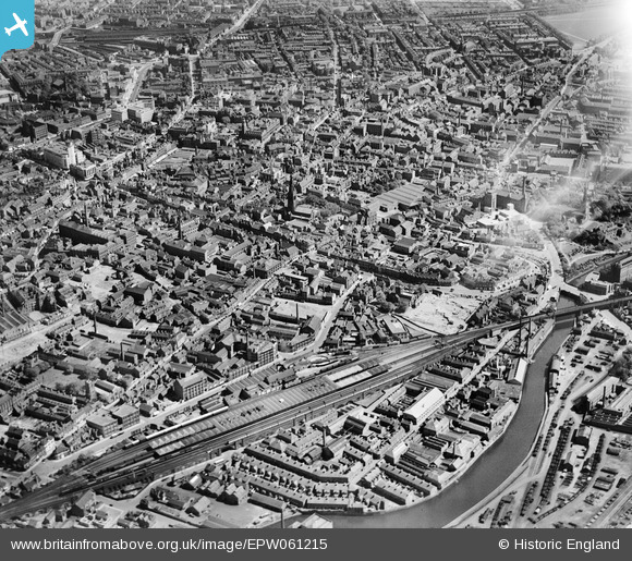
EPW061215 ENGLAND (1939). The city centre, Leicester, 1939
© Copyright OpenStreetMap contributors and licensed by the OpenStreetMap Foundation. 2026. Cartography is licensed as CC BY-SA.
Nearby Images (10)
Details
| Title | [EPW061215] The city centre, Leicester, 1939 |
| Reference | EPW061215 |
| Date | 30-May-1939 |
| Link | |
| Place name | LEICESTER |
| Parish | |
| District | |
| Country | ENGLAND |
| Easting / Northing | 458301, 304609 |
| Longitude / Latitude | -1.1384083357649, 52.6357433788 |
| National Grid Reference | SK583046 |
Pins

mike |
Saturday 9th of January 2021 10:09:10 PM | |

Joanna |
Wednesday 3rd of July 2019 06:49:39 PM | |

DrJACameron |
Wednesday 27th of March 2019 09:12:44 AM | |

DrJACameron |
Wednesday 27th of March 2019 09:10:25 AM | |

face |
Monday 15th of February 2016 08:22:23 PM | |

Peter Kazmierczak |
Sunday 22nd of September 2013 09:24:10 PM | |

diag |
Sunday 22nd of September 2013 08:46:24 PM | |

diag |
Sunday 22nd of September 2013 08:44:45 PM | |

diag |
Sunday 1st of September 2013 01:51:48 PM | |

diag |
Sunday 1st of September 2013 01:50:22 PM | |

diag |
Sunday 1st of September 2013 01:49:23 PM | |

diag |
Sunday 1st of September 2013 01:48:27 PM |


![[EPW061215] The city centre, Leicester, 1939](http://britainfromabove.org.uk/sites/all/libraries/aerofilms-images/public/100x100/EPW/061/EPW061215.jpg)
![[EPW018462] High Cross Street and environs, Leicester, 1927. This image has been produced from a print.](http://britainfromabove.org.uk/sites/all/libraries/aerofilms-images/public/100x100/EPW/018/EPW018462.jpg)
![[EPW014908] Central Station and environs, Leicester, 1926. This image has been produced from a copy-negative.](http://britainfromabove.org.uk/sites/all/libraries/aerofilms-images/public/100x100/EPW/014/EPW014908.jpg)
![[EPW054393] Bath Lane, Leicester Central Railway Station, archaeological excavations at Jewry Wall and environs, Leicester, 1937](http://britainfromabove.org.uk/sites/all/libraries/aerofilms-images/public/100x100/EPW/054/EPW054393.jpg)
![[EPW054391] Bath Lane, Leicester Central Railway Station and environs, Leicester, 1937](http://britainfromabove.org.uk/sites/all/libraries/aerofilms-images/public/100x100/EPW/054/EPW054391.jpg)
![[EPW054388] Bath Lane, Leicester Central Railway Station and environs, Leicester, 1937](http://britainfromabove.org.uk/sites/all/libraries/aerofilms-images/public/100x100/EPW/054/EPW054388.jpg)
![[EPW054392] Bath Lane, Leicester Central Railway Station and environs, Leicester, 1937](http://britainfromabove.org.uk/sites/all/libraries/aerofilms-images/public/100x100/EPW/054/EPW054392.jpg)
![[EPW047644] The city centre, Leicester, from the north-west, 1935](http://britainfromabove.org.uk/sites/all/libraries/aerofilms-images/public/100x100/EPW/047/EPW047644.jpg)
![[EPW054390] Bath Lane, Leicester Central Railway Station and environs, Leicester, 1937](http://britainfromabove.org.uk/sites/all/libraries/aerofilms-images/public/100x100/EPW/054/EPW054390.jpg)
![[EPW054389] The Grand Union Canal, Bath Lane and environs, Leicester, 1937](http://britainfromabove.org.uk/sites/all/libraries/aerofilms-images/public/100x100/EPW/054/EPW054389.jpg)