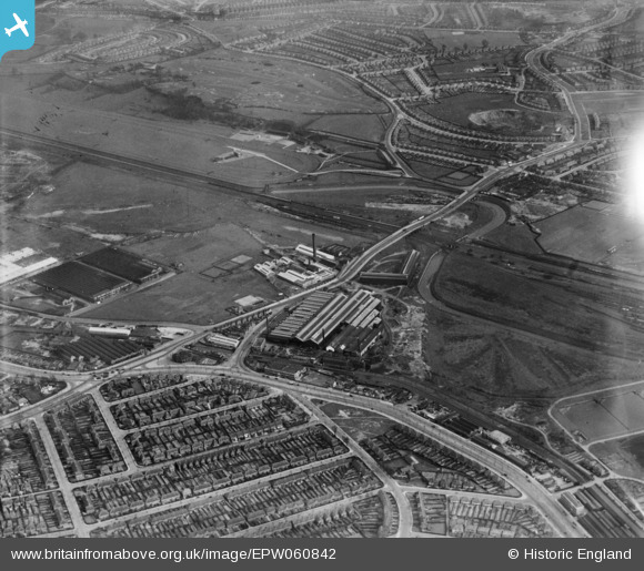
EPW060842 ENGLAND (1939). The Bromford Tube Co Works and the surrounding residential area, Bromford, 1939
© Copyright OpenStreetMap contributors and licensed by the OpenStreetMap Foundation. 2026. Cartography is licensed as CC BY-SA.
Nearby Images (19)
Details
| Title | [EPW060842] The Bromford Tube Co Works and the surrounding residential area, Bromford, 1939 |
| Reference | EPW060842 |
| Date | 25-April-1939 |
| Link | |
| Place name | BROMFORD |
| Parish | |
| District | |
| Country | ENGLAND |
| Easting / Northing | 411491, 289901 |
| Longitude / Latitude | -1.8306822373366, 52.506517087988 |
| National Grid Reference | SP115899 |
Pins

frothy |
Monday 3rd of July 2017 11:55:06 AM |


![[EPW060842] The Bromford Tube Co Works and the surrounding residential area, Bromford, 1939](http://britainfromabove.org.uk/sites/all/libraries/aerofilms-images/public/100x100/EPW/060/EPW060842.jpg)
![[EPW060845] The Bromford Tube Co Works, the Birmingham Race Course and the surrounding residential area, Bromford, 1939](http://britainfromabove.org.uk/sites/all/libraries/aerofilms-images/public/100x100/EPW/060/EPW060845.jpg)
![[EPW060841] The Bromford Tube Co Works and the Valor Oil Heaters Works, Bromford, 1939](http://britainfromabove.org.uk/sites/all/libraries/aerofilms-images/public/100x100/EPW/060/EPW060841.jpg)
![[EPW060838] The Bromford Tube Co Works, Bromford, 1939](http://britainfromabove.org.uk/sites/all/libraries/aerofilms-images/public/100x100/EPW/060/EPW060838.jpg)
![[EPW060844] The Bromford Tube Co Works, the Birmingham Race Course and the surrounding residential area, Bromford, 1939](http://britainfromabove.org.uk/sites/all/libraries/aerofilms-images/public/100x100/EPW/060/EPW060844.jpg)
![[EPW060846] The Bromford Tube Co Works, the Birmingham Race Course and the surrounding residential area, Bromford, 1939](http://britainfromabove.org.uk/sites/all/libraries/aerofilms-images/public/100x100/EPW/060/EPW060846.jpg)
![[EPW035903] The Bromford Tube Co Tube Works, the Rollasons Wire Co Wire Mills and Bromford Lane, Birmingham, 1931](http://britainfromabove.org.uk/sites/all/libraries/aerofilms-images/public/100x100/EPW/035/EPW035903.jpg)
![[EPW060839] The Bromford Tube Co Works, Bromford, 1939](http://britainfromabove.org.uk/sites/all/libraries/aerofilms-images/public/100x100/EPW/060/EPW060839.jpg)
![[EPW060847] The Bromford Tube Co Works, the Birmingham Race Course and the surrounding residential area, Bromford, 1939](http://britainfromabove.org.uk/sites/all/libraries/aerofilms-images/public/100x100/EPW/060/EPW060847.jpg)
![[EPW060843] The Bromford Tube Co Works, Bromford, 1939](http://britainfromabove.org.uk/sites/all/libraries/aerofilms-images/public/100x100/EPW/060/EPW060843.jpg)
![[EPW035904] The Bromford Tube Co Tube Works, the Rollasons Wire Co Wire Mills and Bromford Lane, Birmingham, 1931](http://britainfromabove.org.uk/sites/all/libraries/aerofilms-images/public/100x100/EPW/035/EPW035904.jpg)
![[EPW015255] The Bromford Tube Co Tube Works, Birmingham, 1926. This image has been produced from a print.](http://britainfromabove.org.uk/sites/all/libraries/aerofilms-images/public/100x100/EPW/015/EPW015255.jpg)
![[EPW060840] The Bromford Tube Co Works, the Valor Oil Heaters Works and the surrounding residential area, Bromford, 1939](http://britainfromabove.org.uk/sites/all/libraries/aerofilms-images/public/100x100/EPW/060/EPW060840.jpg)
![[EPW035899] The Bromford Tube Co Tube Works, Wheelwright Road and the Frankbury Manufacturing Co Mangle Works, Birmingham, 1931](http://britainfromabove.org.uk/sites/all/libraries/aerofilms-images/public/100x100/EPW/035/EPW035899.jpg)
![[EPW035906] The Bromford Tube Co Tube Works and the Frankby Manufacturing Co Mangle Works, Birmingham, 1931](http://britainfromabove.org.uk/sites/all/libraries/aerofilms-images/public/100x100/EPW/035/EPW035906.jpg)
![[EPW035905] The Bromford Tube Co Tube Works, the Frankby Manufacturing Co Mangle Works and Bromford Lane, Birmingham, 1931](http://britainfromabove.org.uk/sites/all/libraries/aerofilms-images/public/100x100/EPW/035/EPW035905.jpg)
![[EPW060849] The Bromford Tube Co Works, the Birmingham Race Course and the surrounding residential area, Bromford, 1939](http://britainfromabove.org.uk/sites/all/libraries/aerofilms-images/public/100x100/EPW/060/EPW060849.jpg)
![[EPW035900] The Bromford Tube Co Tube Works, the Frankbury Manufacturing Co Mangle Works and Tyburn Road, Birmingham, 1931](http://britainfromabove.org.uk/sites/all/libraries/aerofilms-images/public/100x100/EPW/035/EPW035900.jpg)
![[EPW031996] The Valor Works and environs, Bromford, 1930](http://britainfromabove.org.uk/sites/all/libraries/aerofilms-images/public/100x100/EPW/031/EPW031996.jpg)