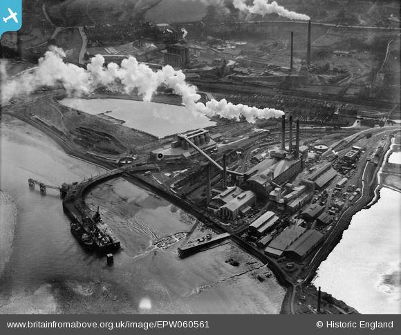
EPW060561 ENGLAND (1939). The Kent Portland Cement Works and Jetty, Stone, 1939
© Copyright OpenStreetMap contributors and licensed by the OpenStreetMap Foundation. 2026. Cartography is licensed as CC BY-SA.
Nearby Images (14)
Details
| Title | [EPW060561] The Kent Portland Cement Works and Jetty, Stone, 1939 |
| Reference | EPW060561 |
| Date | 27-February-1939 |
| Link | |
| Place name | STONE |
| Parish | STONE |
| District | |
| Country | ENGLAND |
| Easting / Northing | 557805, 175223 |
| Longitude / Latitude | 0.27146878935587, 51.453476659574 |
| National Grid Reference | TQ578752 |
Pins

Dylan Moore |
Wednesday 26th of November 2014 12:55:42 PM | |

Dylan Moore |
Saturday 15th of June 2013 10:39:49 AM | |

Dylan Moore |
Saturday 15th of June 2013 10:38:30 AM | |

Dylan Moore |
Saturday 15th of June 2013 10:38:04 AM | |

Dylan Moore |
Saturday 15th of June 2013 10:37:34 AM | |

Dylan Moore |
Saturday 15th of June 2013 10:36:29 AM | |

Dylan Moore |
Saturday 15th of June 2013 10:36:13 AM | |

Dylan Moore |
Saturday 15th of June 2013 10:35:53 AM | |

Dylan Moore |
Saturday 15th of June 2013 10:35:30 AM | |

Dylan Moore |
Saturday 15th of June 2013 10:34:59 AM | |

Dylan Moore |
Saturday 15th of June 2013 10:34:46 AM |


![[EPW060561] The Kent Portland Cement Works and Jetty, Stone, 1939](http://britainfromabove.org.uk/sites/all/libraries/aerofilms-images/public/100x100/EPW/060/EPW060561.jpg)
![[EPW060568] The Kent Portland Cement Works and Jetty, Stone, 1939](http://britainfromabove.org.uk/sites/all/libraries/aerofilms-images/public/100x100/EPW/060/EPW060568.jpg)
![[EPW060563] The Kent Portland Cement Works, Stone, 1939](http://britainfromabove.org.uk/sites/all/libraries/aerofilms-images/public/100x100/EPW/060/EPW060563.jpg)
![[EPW060960] Portland Cement Works and the River Thames, Stone, 1939](http://britainfromabove.org.uk/sites/all/libraries/aerofilms-images/public/100x100/EPW/060/EPW060960.jpg)
![[EPW060566] The Kent Portland Cement Works and Jetty, Stone, 1939](http://britainfromabove.org.uk/sites/all/libraries/aerofilms-images/public/100x100/EPW/060/EPW060566.jpg)
![[EPW060570] The Kent Portland Cement Works and Jetty, Stone, 1939. This image was marked by Aerofilms Ltd for photo editing.](http://britainfromabove.org.uk/sites/all/libraries/aerofilms-images/public/100x100/EPW/060/EPW060570.jpg)
![[EPW060565] The Kent Portland Cement Works and Jetty, Stone, 1939](http://britainfromabove.org.uk/sites/all/libraries/aerofilms-images/public/100x100/EPW/060/EPW060565.jpg)
![[EPW060564] The Kent Portland Cement Works and Jetty, Stone, 1939](http://britainfromabove.org.uk/sites/all/libraries/aerofilms-images/public/100x100/EPW/060/EPW060564.jpg)
![[EPW060571] The Kent Portland Cement Works and Jetty, Stone, 1939. This image has been produced from a damaged negative.](http://britainfromabove.org.uk/sites/all/libraries/aerofilms-images/public/100x100/EPW/060/EPW060571.jpg)
![[EPW017653] The Kent Portland Cement Works, Stone, 1927](http://britainfromabove.org.uk/sites/all/libraries/aerofilms-images/public/100x100/EPW/017/EPW017653.jpg)
![[EPW060567] The Kent Portland Cement Works and Jetty, Stone, 1939. This image has been produced from a damaged negative.](http://britainfromabove.org.uk/sites/all/libraries/aerofilms-images/public/100x100/EPW/060/EPW060567.jpg)
![[EPW060562] The Kent Portland Cement Works and Jetty, Stone, 1939](http://britainfromabove.org.uk/sites/all/libraries/aerofilms-images/public/100x100/EPW/060/EPW060562.jpg)
![[EPW060569] The Kent Portland Cement Works and housing along Charles Street, Stone, 1939](http://britainfromabove.org.uk/sites/all/libraries/aerofilms-images/public/100x100/EPW/060/EPW060569.jpg)
![[EPW060602] The Johnson's and the Kent Portland Cement Works, Stone, 1939](http://britainfromabove.org.uk/sites/all/libraries/aerofilms-images/public/100x100/EPW/060/EPW060602.jpg)