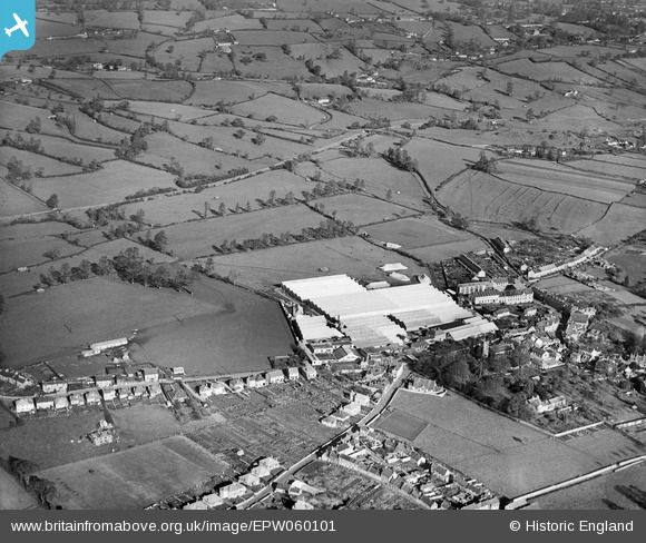
EPW060101 ENGLAND (1938). The Purnell and Sons Ltd Printing Works and surrounding countryside, Paulton, 1938
© Copyright OpenStreetMap contributors and licensed by the OpenStreetMap Foundation. 2026. Cartography is licensed as CC BY-SA.
Nearby Images (15)
Details
| Title | [EPW060101] The Purnell and Sons Ltd Printing Works and surrounding countryside, Paulton, 1938 |
| Reference | EPW060101 |
| Date | 1-November-1938 |
| Link | |
| Place name | PAULTON |
| Parish | PAULTON |
| District | |
| Country | ENGLAND |
| Easting / Northing | 364955, 156944 |
| Longitude / Latitude | -2.5028405753027, 51.310025288699 |
| National Grid Reference | ST650569 |
Pins

Class31 |
Sunday 18th of January 2015 11:52:22 AM | |

Class31 |
Sunday 18th of January 2015 11:22:33 AM | |

Andrew |
Saturday 23rd of November 2013 11:40:15 AM | |

rogergh |
Sunday 3rd of November 2013 11:11:16 AM | |

rogergh |
Sunday 3rd of November 2013 11:10:07 AM | |

rogergh |
Sunday 3rd of November 2013 11:07:36 AM | |

MB |
Sunday 27th of October 2013 06:13:54 PM | |

MB |
Sunday 27th of October 2013 06:12:54 PM | |

MB |
Sunday 27th of October 2013 06:10:49 PM | |

MB |
Sunday 27th of October 2013 06:10:11 PM | |

MB |
Sunday 27th of October 2013 06:09:20 PM | |

Class31 |
Saturday 29th of June 2013 09:29:48 PM | |

Class31 |
Saturday 29th of June 2013 09:25:49 PM | |

Class31 |
Saturday 29th of June 2013 09:21:27 PM |


![[EPW060101] The Purnell and Sons Ltd Printing Works and surrounding countryside, Paulton, 1938](http://britainfromabove.org.uk/sites/all/libraries/aerofilms-images/public/100x100/EPW/060/EPW060101.jpg)
![[EAW047204] Purnell and Sons Ltd Printing Works and surrounding countryside, Paulton, from the south-east, 1952. This image was marked by Aerofilms Ltd for photo editing.](http://britainfromabove.org.uk/sites/all/libraries/aerofilms-images/public/100x100/EAW/047/EAW047204.jpg)
![[EAW047206] Purnell and Sons Ltd Printing Works, the village and surrounding countryside, Paulton, from the north-west, 1952. This image was marked by Aerofilms Ltd for photo editing.](http://britainfromabove.org.uk/sites/all/libraries/aerofilms-images/public/100x100/EAW/047/EAW047206.jpg)
![[EAW047195] Purnell and Sons Ltd Printing Works, Paulton, 1952. This image was marked by Aerofilms Ltd for photo editing.](http://britainfromabove.org.uk/sites/all/libraries/aerofilms-images/public/100x100/EAW/047/EAW047195.jpg)
![[EPW060102] The Purnell and Sons Ltd Printing Works and surrounding countryside, Paulton, 1938. This image has been produced from a damaged negative.](http://britainfromabove.org.uk/sites/all/libraries/aerofilms-images/public/100x100/EPW/060/EPW060102.jpg)
![[EAW047201] Purnell and Sons Ltd Printing Works and the village, Paulton, from the north-west, 1952. This image was marked by Aerofilms Ltd for photo editing.](http://britainfromabove.org.uk/sites/all/libraries/aerofilms-images/public/100x100/EAW/047/EAW047201.jpg)
![[EAW047199] Purnell and Sons Ltd Printing Works, Paulton, 1952. This image was marked by Aerofilms Ltd for photo editing.](http://britainfromabove.org.uk/sites/all/libraries/aerofilms-images/public/100x100/EAW/047/EAW047199.jpg)
![[EPW060103] The Purnell and Sons Ltd Printing Works, Paulton, 1938](http://britainfromabove.org.uk/sites/all/libraries/aerofilms-images/public/100x100/EPW/060/EPW060103.jpg)
![[EAW047197] Purnell and Sons Ltd Printing Works and the village, Paulton, from the north-west, 1952. This image was marked by Aerofilms Ltd for photo editing.](http://britainfromabove.org.uk/sites/all/libraries/aerofilms-images/public/100x100/EAW/047/EAW047197.jpg)
![[EAW047202] Purnell and Sons Ltd Printing Works and environs, Paulton, 1952. This image was marked by Aerofilms Ltd for photo editing.](http://britainfromabove.org.uk/sites/all/libraries/aerofilms-images/public/100x100/EAW/047/EAW047202.jpg)
![[EAW047196] Purnell and Sons Ltd Printing Works and the village, Paulton, 1952. This image was marked by Aerofilms Ltd for photo editing.](http://britainfromabove.org.uk/sites/all/libraries/aerofilms-images/public/100x100/EAW/047/EAW047196.jpg)
![[EPW060104] The Purnell and Sons Ltd Printing Works, Paulton, 1938](http://britainfromabove.org.uk/sites/all/libraries/aerofilms-images/public/100x100/EPW/060/EPW060104.jpg)
![[EAW047200] Purnell and Sons Ltd Printing Works, Paulton, 1952. This image was marked by Aerofilms Ltd for photo editing.](http://britainfromabove.org.uk/sites/all/libraries/aerofilms-images/public/100x100/EAW/047/EAW047200.jpg)
![[EPR000119] Ashman Bros Ltd Boot and Shoe Factory, Paulton, 1934](http://britainfromabove.org.uk/sites/all/libraries/aerofilms-images/public/100x100/EPR/000/EPR000119.jpg)
![[EAW047203] Purnell and Sons Ltd Printing Works and environs, Paulton, from the east, 1952. This image was marked by Aerofilms Ltd for photo editing.](http://britainfromabove.org.uk/sites/all/libraries/aerofilms-images/public/100x100/EAW/047/EAW047203.jpg)