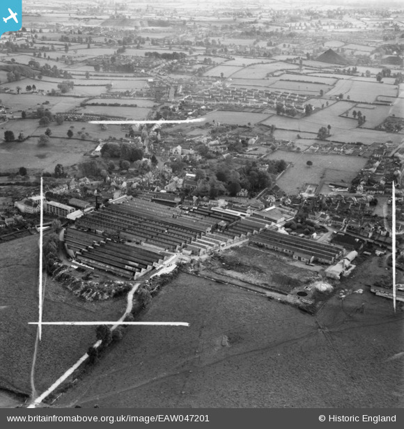
EAW047201 ENGLAND (1952). Purnell and Sons Ltd Printing Works and the village, Paulton, from the north-west, 1952. This image was marked by Aerofilms Ltd for photo editing.
© Copyright OpenStreetMap contributors and licensed by the OpenStreetMap Foundation. 2026. Cartography is licensed as CC BY-SA.
Nearby Images (23)
Details
| Title | [EAW047201] Purnell and Sons Ltd Printing Works and the village, Paulton, from the north-west, 1952. This image was marked by Aerofilms Ltd for photo editing. |
| Reference | EAW047201 |
| Date | 9-October-1952 |
| Link | |
| Place name | PAULTON |
| Parish | PAULTON |
| District | |
| Country | ENGLAND |
| Easting / Northing | 364864, 156783 |
| Longitude / Latitude | -2.5041303630595, 51.308571890931 |
| National Grid Reference | ST649568 |
Pins
Be the first to add a comment to this image!
User Comment Contributions
Holy Trinity Church, Paulton, 17/01/2015 |

Class31 |
Sunday 18th of January 2015 10:48:37 AM |


![[EAW047201] Purnell and Sons Ltd Printing Works and the village, Paulton, from the north-west, 1952. This image was marked by Aerofilms Ltd for photo editing.](http://britainfromabove.org.uk/sites/all/libraries/aerofilms-images/public/100x100/EAW/047/EAW047201.jpg)
![[EAW047197] Purnell and Sons Ltd Printing Works and the village, Paulton, from the north-west, 1952. This image was marked by Aerofilms Ltd for photo editing.](http://britainfromabove.org.uk/sites/all/libraries/aerofilms-images/public/100x100/EAW/047/EAW047197.jpg)
![[EPW060103] The Purnell and Sons Ltd Printing Works, Paulton, 1938](http://britainfromabove.org.uk/sites/all/libraries/aerofilms-images/public/100x100/EPW/060/EPW060103.jpg)
![[EAW047195] Purnell and Sons Ltd Printing Works, Paulton, 1952. This image was marked by Aerofilms Ltd for photo editing.](http://britainfromabove.org.uk/sites/all/libraries/aerofilms-images/public/100x100/EAW/047/EAW047195.jpg)
![[EPW060102] The Purnell and Sons Ltd Printing Works and surrounding countryside, Paulton, 1938. This image has been produced from a damaged negative.](http://britainfromabove.org.uk/sites/all/libraries/aerofilms-images/public/100x100/EPW/060/EPW060102.jpg)
![[EAW047202] Purnell and Sons Ltd Printing Works and environs, Paulton, 1952. This image was marked by Aerofilms Ltd for photo editing.](http://britainfromabove.org.uk/sites/all/libraries/aerofilms-images/public/100x100/EAW/047/EAW047202.jpg)
![[EPW060104] The Purnell and Sons Ltd Printing Works, Paulton, 1938](http://britainfromabove.org.uk/sites/all/libraries/aerofilms-images/public/100x100/EPW/060/EPW060104.jpg)
![[EAW047204] Purnell and Sons Ltd Printing Works and surrounding countryside, Paulton, from the south-east, 1952. This image was marked by Aerofilms Ltd for photo editing.](http://britainfromabove.org.uk/sites/all/libraries/aerofilms-images/public/100x100/EAW/047/EAW047204.jpg)
![[EAW047198] Purnell and Sons Ltd Printing Works and environs, Paulton, from the south-west, 1952. This image was marked by Aerofilms Ltd for photo editing.](http://britainfromabove.org.uk/sites/all/libraries/aerofilms-images/public/100x100/EAW/047/EAW047198.jpg)
![[EAW047196] Purnell and Sons Ltd Printing Works and the village, Paulton, 1952. This image was marked by Aerofilms Ltd for photo editing.](http://britainfromabove.org.uk/sites/all/libraries/aerofilms-images/public/100x100/EAW/047/EAW047196.jpg)
![[EPR000118] Purnell and Sons Ltd Printing Works, Paulton, 1934](http://britainfromabove.org.uk/sites/all/libraries/aerofilms-images/public/100x100/EPR/000/EPR000118.jpg)
![[EPR000116] Purnell and Sons Ltd Printing Works, Paulton, 1934](http://britainfromabove.org.uk/sites/all/libraries/aerofilms-images/public/100x100/EPR/000/EPR000116.jpg)
![[EAW047199] Purnell and Sons Ltd Printing Works, Paulton, 1952. This image was marked by Aerofilms Ltd for photo editing.](http://britainfromabove.org.uk/sites/all/libraries/aerofilms-images/public/100x100/EAW/047/EAW047199.jpg)
![[EAW047200] Purnell and Sons Ltd Printing Works, Paulton, 1952. This image was marked by Aerofilms Ltd for photo editing.](http://britainfromabove.org.uk/sites/all/libraries/aerofilms-images/public/100x100/EAW/047/EAW047200.jpg)
![[EPR000117] Purnell and Sons Ltd Printing Works, Paulton, 1934](http://britainfromabove.org.uk/sites/all/libraries/aerofilms-images/public/100x100/EPR/000/EPR000117.jpg)
![[EPW060100] The Purnell and Sons Ltd Printing Works, Paulton, 1938](http://britainfromabove.org.uk/sites/all/libraries/aerofilms-images/public/100x100/EPW/060/EPW060100.jpg)
![[EPW060101] The Purnell and Sons Ltd Printing Works and surrounding countryside, Paulton, 1938](http://britainfromabove.org.uk/sites/all/libraries/aerofilms-images/public/100x100/EPW/060/EPW060101.jpg)
![[EPW033304] Church Street and environs, Paulton, 1930](http://britainfromabove.org.uk/sites/all/libraries/aerofilms-images/public/100x100/EPW/033/EPW033304.jpg)
![[EPR000119] Ashman Bros Ltd Boot and Shoe Factory, Paulton, 1934](http://britainfromabove.org.uk/sites/all/libraries/aerofilms-images/public/100x100/EPR/000/EPR000119.jpg)
![[EAW047206] Purnell and Sons Ltd Printing Works, the village and surrounding countryside, Paulton, from the north-west, 1952. This image was marked by Aerofilms Ltd for photo editing.](http://britainfromabove.org.uk/sites/all/libraries/aerofilms-images/public/100x100/EAW/047/EAW047206.jpg)
![[EPW033303] High Park Corner and Paulton Print Works, Paulton, 1930](http://britainfromabove.org.uk/sites/all/libraries/aerofilms-images/public/100x100/EPW/033/EPW033303.jpg)
![[EAW047203] Purnell and Sons Ltd Printing Works and environs, Paulton, from the east, 1952. This image was marked by Aerofilms Ltd for photo editing.](http://britainfromabove.org.uk/sites/all/libraries/aerofilms-images/public/100x100/EAW/047/EAW047203.jpg)
![[EPW033302] The village, Paulton, 1930](http://britainfromabove.org.uk/sites/all/libraries/aerofilms-images/public/100x100/EPW/033/EPW033302.jpg)