
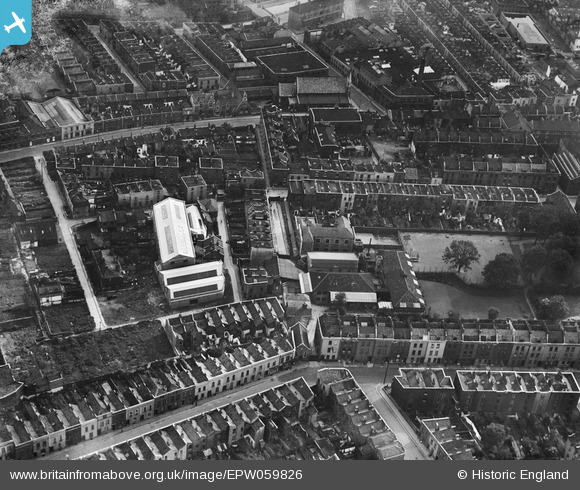
EPW059826 ENGLAND (1938). St Paul's National School, St Paul's Park and environs, Bristol, 1938
© Copyright OpenStreetMap contributors and licensed by the OpenStreetMap Foundation. 2026. Cartography is licensed as CC BY-SA.
Nearby Images (6)
EPW059826

EPW059825

EPW059823

EPW059827

EPW059828

EPW012228

Details
| Title | [EPW059826] St Paul's National School, St Paul's Park and environs, Bristol, 1938 |
| Reference | EPW059826 |
| Date | 1-October-1938 |
| Link | |
| Place name | BRISTOL |
| Parish | |
| District | |
| Country | ENGLAND |
| Easting / Northing | 359626, 173787 |
| Longitude / Latitude | -2.5812148970545, 51.461128045957 |
| National Grid Reference | ST596738 |
Pins

MildBunch |
Wednesday 18th of February 2015 02:19:01 PM | |
|
MildBunch |
Wednesday 18th of February 2015 02:18:12 PM | |

Class31 |
Monday 10th of March 2014 04:26:08 PM | |
|
Class31 |
Monday 10th of March 2014 04:25:40 PM | |
|
Class31 |
Monday 10th of March 2014 04:24:33 PM | |
|
Class31 |
Monday 10th of March 2014 04:23:57 PM | |
|
Class31 |
Monday 10th of March 2014 04:23:05 PM | |
|
Class31 |
Monday 10th of March 2014 04:22:24 PM | |
|
Class31 |
Monday 10th of March 2014 04:22:00 PM | |
|
Class31 |
Monday 10th of March 2014 04:21:00 PM | |
|
Class31 |
Monday 10th of March 2014 04:16:50 PM | |
|
Class31 |
Monday 10th of March 2014 04:16:19 PM | |
|
Class31 |
Monday 10th of March 2014 04:15:57 PM |
User Comment Contributions
View is looking south east. |
Class31 |
Monday 10th of March 2014 04:20:20 PM |