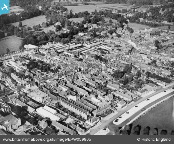
EPW059805 ENGLAND (1938). Northbrook and environs, Newbury, 1938. This image has been produced from a copy-negative.
© Copyright OpenStreetMap contributors and licensed by the OpenStreetMap Foundation. 2026. Cartography is licensed as CC BY-SA.
Nearby Images (7)
Details
| Title | [EPW059805] Northbrook and environs, Newbury, 1938. This image has been produced from a copy-negative. |
| Reference | EPW059805 |
| Date | 5-October-1938 |
| Link | |
| Place name | NEWBURY |
| Parish | NEWBURY |
| District | |
| Country | ENGLAND |
| Easting / Northing | 447066, 167455 |
| Longitude / Latitude | -1.3232970479556, 51.403673764903 |
| National Grid Reference | SU471675 |
Pins
Be the first to add a comment to this image!


![[EPW059805] Northbrook and environs, Newbury, 1938. This image has been produced from a copy-negative.](http://britainfromabove.org.uk/sites/all/libraries/aerofilms-images/public/100x100/EPW/059/EPW059805.jpg)
![[EPW022634] Broadway, Newbury, 1928](http://britainfromabove.org.uk/sites/all/libraries/aerofilms-images/public/100x100/EPW/022/EPW022634.jpg)
![[EPW054603] The Broadway, Victoria Park and environs, Newbury, 1937. This image has been produced from a copy-negative.](http://britainfromabove.org.uk/sites/all/libraries/aerofilms-images/public/100x100/EPW/054/EPW054603.jpg)
![[EAW041720] The town, Newbury, 1952](http://britainfromabove.org.uk/sites/all/libraries/aerofilms-images/public/100x100/EAW/041/EAW041720.jpg)
![[EPW059799] The Broadway, Newbury, 1938](http://britainfromabove.org.uk/sites/all/libraries/aerofilms-images/public/100x100/EPW/059/EPW059799.jpg)
![[EPW059806] The Broadway, Newbury, 1938. This image has been produced from a copy-negative.](http://britainfromabove.org.uk/sites/all/libraries/aerofilms-images/public/100x100/EPW/059/EPW059806.jpg)
![[EPW022633] Newbury and environs, Newbury, from the north-west, 1928](http://britainfromabove.org.uk/sites/all/libraries/aerofilms-images/public/100x100/EPW/022/EPW022633.jpg)